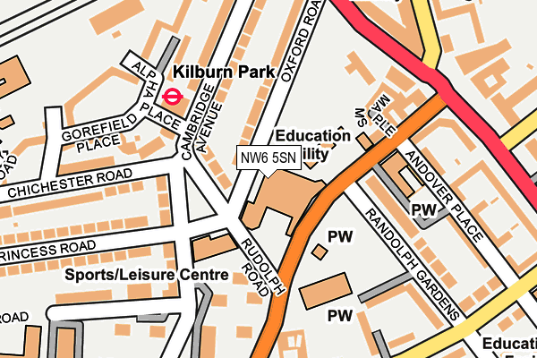
NW6 5SN is located in the Maida Vale electoral ward, within the London borough of Westminster and the English Parliamentary constituency of Westminster North. The Sub Integrated Care Board (ICB) Location is NHS North West London ICB - W2U3Z and the police force is Metropolitan Police. This postcode has been in use since January 1980.


GetTheData
Source: OS OpenMap – Local (Ordnance Survey)
Source: OS VectorMap District (Ordnance Survey)
Licence: Open Government Licence (requires attribution)
| Easting | 525469 |
| Northing | 183256 |
| Latitude | 51.534275 |
| Longitude | -0.192443 |
GetTheData
Source: Open Postcode Geo
Licence: Open Government Licence
| Country | England |
| Postcode District | NW6 |
| ➜ NW6 open data dashboard ➜ See where NW6 is on a map ➜ Where is London? | |
GetTheData
Source: Land Registry Price Paid Data
Licence: Open Government Licence
Elevation or altitude of NW6 5SN as distance above sea level:
| Metres | Feet | |
|---|---|---|
| Elevation | 30m | 98ft |
Elevation is measured from the approximate centre of the postcode, to the nearest point on an OS contour line from OS Terrain 50, which has contour spacing of ten vertical metres.
➜ How high above sea level am I? Find the elevation of your current position using your device's GPS.
GetTheData
Source: Open Postcode Elevation
Licence: Open Government Licence
| Ward | Maida Vale |
| Constituency | Westminster North |
GetTheData
Source: ONS Postcode Database
Licence: Open Government Licence
| January 2024 | Burglary | On or near Greville Road | 470m |
| December 2023 | Bicycle theft | On or near Cambridge Road | 333m |
| December 2023 | Burglary | On or near Cambridge Road | 333m |
| ➜ Get more crime data in our Crime section | |||
GetTheData
Source: data.police.uk
Licence: Open Government Licence
| Kilburn Park | Kilburn Park | 88m |
| Kilburn Park (Cambridge Avenue) | Kilburn Park | 98m |
| Rudolph Road | Maida Vale | 112m |
| Kilburn Park (Cambridge Avenue) | Kilburn Park | 148m |
| Carlton Vale Maida Vale (Kilburn Park Road) | Maida Vale | 156m |
| Kilburn Park Underground Station | Kilburn Park | 147m |
| Maida Vale Underground Station | Maida Vale | 682m |
| Queen's Park Underground Station | Queen's Park | 842m |
| St. John's Wood Underground Station | St Johns Wood | 1,283m |
| Warwick Avenue Underground Station | Warwick Avenue | 1,365m |
| Kilburn High Road Station | 0.3km |
| Queens Park (London) Station | 0.9km |
| South Hampstead Station | 1.2km |
GetTheData
Source: NaPTAN
Licence: Open Government Licence
GetTheData
Source: ONS Postcode Database
Licence: Open Government Licence


➜ Get more ratings from the Food Standards Agency
GetTheData
Source: Food Standards Agency
Licence: FSA terms & conditions
| Last Collection | |||
|---|---|---|---|
| Location | Mon-Fri | Sat | Distance |
| Cambridge Gardens | 17:30 | 12:00 | 71m |
| High Road | 18:30 | 12:00 | 227m |
| Maida Vale | 17:30 | 12:00 | 236m |
GetTheData
Source: Dracos
Licence: Creative Commons Attribution-ShareAlike
| Facility | Distance |
|---|---|
| St Augustine's Sports Centre Oxford Road, London Sports Hall, Artificial Grass Pitch | 0m |
| Bannatyne Health Club (Maida Vale) Greville Road, London Health and Fitness Gym, Swimming Pool, Studio | 230m |
| Anytime Fitness (London Kilburn) Kilburn High Road, Kilburn High Road, London Health and Fitness Gym | 242m |
GetTheData
Source: Active Places
Licence: Open Government Licence
| School | Phase of Education | Distance |
|---|---|---|
| St Augustine's Federated Schools: CE High School Oxford Road, London, NW6 5SN | Secondary | 0m |
| St Augustines Federated Schools: CofE Primary School Kilburn Park Road, Kilburn, London, NW6 5XA | Primary | 66m |
| Naima Jewish Preparatory School 21 Andover Place, London, NW6 5ED | Not applicable | 164m |
GetTheData
Source: Edubase
Licence: Open Government Licence
The below table lists the International Territorial Level (ITL) codes (formerly Nomenclature of Territorial Units for Statistics (NUTS) codes) and Local Administrative Units (LAU) codes for NW6 5SN:
| ITL 1 Code | Name |
|---|---|
| TLI | London |
| ITL 2 Code | Name |
| TLI3 | Inner London - West |
| ITL 3 Code | Name |
| TLI32 | Westminster |
| LAU 1 Code | Name |
| E09000033 | Westminster |
GetTheData
Source: ONS Postcode Directory
Licence: Open Government Licence
The below table lists the Census Output Area (OA), Lower Layer Super Output Area (LSOA), and Middle Layer Super Output Area (MSOA) for NW6 5SN:
| Code | Name | |
|---|---|---|
| OA | E00023791 | |
| LSOA | E01004710 | Westminster 002D |
| MSOA | E02000961 | Westminster 002 |
GetTheData
Source: ONS Postcode Directory
Licence: Open Government Licence
| NW6 5AY | Cambridge Gardens | 66m |
| NW6 5SL | Oxford Road | 108m |
| NW6 5AE | Cambridge Gardens | 120m |
| NW6 5UY | Kilburn Park Road | 136m |
| NW6 5BA | Cambridge Avenue | 142m |
| NW6 5UZ | Maple Mews | 148m |
| NW6 5HP | Randolph Gardens | 158m |
| NW6 5HR | Randolph Gardens | 158m |
| NW6 5QS | Chichester Road | 160m |
| NW6 5SG | Tollgate Gardens | 161m |
GetTheData
Source: Open Postcode Geo; Land Registry Price Paid Data
Licence: Open Government Licence