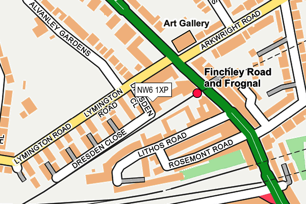
NW6 1XP is located in the West Hampstead electoral ward, within the London borough of Camden and the English Parliamentary constituency of Hampstead and Kilburn. The Sub Integrated Care Board (ICB) Location is NHS North Central London ICB - 93C and the police force is Metropolitan Police. This postcode has been in use since February 1990.


GetTheData
Source: OS OpenMap – Local (Ordnance Survey)
Source: OS VectorMap District (Ordnance Survey)
Licence: Open Government Licence (requires attribution)
| Easting | 525982 |
| Northing | 185031 |
| Latitude | 51.550113 |
| Longitude | -0.184416 |
GetTheData
Source: Open Postcode Geo
Licence: Open Government Licence
| Country | England |
| Postcode District | NW6 |
| ➜ NW6 open data dashboard ➜ See where NW6 is on a map ➜ Where is Hampstead? | |
GetTheData
Source: Land Registry Price Paid Data
Licence: Open Government Licence
Elevation or altitude of NW6 1XP as distance above sea level:
| Metres | Feet | |
|---|---|---|
| Elevation | 60m | 197ft |
Elevation is measured from the approximate centre of the postcode, to the nearest point on an OS contour line from OS Terrain 50, which has contour spacing of ten vertical metres.
➜ How high above sea level am I? Find the elevation of your current position using your device's GPS.
GetTheData
Source: Open Postcode Elevation
Licence: Open Government Licence
| Ward | West Hampstead |
| Constituency | Hampstead And Kilburn |
GetTheData
Source: ONS Postcode Database
Licence: Open Government Licence
| June 2022 | Violence and sexual offences | On or near Lithos Road | 83m |
| June 2022 | Violence and sexual offences | On or near Lithos Road | 83m |
| June 2022 | Other theft | On or near Beswick Mews | 91m |
| ➜ Get more crime data in our Crime section | |||
GetTheData
Source: data.police.uk
Licence: Open Government Licence
| Finchley Road & Frognal Station | West Hampstead | 102m |
| Finchley Road & Frognal Station | West Hampstead | 144m |
| Langland Gardens (Nw3) | West Hampstead | 160m |
| Langland Gardens (Nw3) | West Hampstead | 190m |
| 02 Centre Sainsbury's | South Hampstead | 222m |
| Finchley Road Underground Station | Finchley Road | 484m |
| West Hampstead Underground Station | West Hampstead | 602m |
| Hampstead Underground Station | Hampstead | 833m |
| Swiss Cottage Underground Station | Swiss Cottage | 974m |
| Belsize Park Underground Station | Belsize Park | 1,371m |
| Finchley Road & Frognal Station | 0.1km |
| West Hampstead Thameslink Station | 0.5km |
| West Hampstead Station | 0.6km |
GetTheData
Source: NaPTAN
Licence: Open Government Licence
GetTheData
Source: ONS Postcode Database
Licence: Open Government Licence


➜ Get more ratings from the Food Standards Agency
GetTheData
Source: Food Standards Agency
Licence: FSA terms & conditions
| Last Collection | |||
|---|---|---|---|
| Location | Mon-Fri | Sat | Distance |
| Hampstead Post Office | 18:30 | 12:00 | 161m |
| Lymington Road | 17:30 | 12:00 | 182m |
| Finchley Road | 17:30 | 12:00 | 204m |
GetTheData
Source: Dracos
Licence: Creative Commons Attribution-ShareAlike
| Facility | Distance |
|---|---|
| Cumberland Lawn Tennis Club And Hampstead Cricket Club Alvanley Gardens, London Health and Fitness Gym, Grass Pitches, Squash Courts, Studio, Outdoor Tennis Courts | 260m |
| Virgin Active (Swiss Cottage) Finchley Road, London Swimming Pool, Health and Fitness Gym, Studio | 318m |
| Southbank International School (Hampstead Campus) Netherhall Gardens, London Artificial Grass Pitch | 394m |
GetTheData
Source: Active Places
Licence: Open Government Licence
| School | Phase of Education | Distance |
|---|---|---|
| Southbank International School Hampstead 16 Netherhall Gardens, London, NW3 5TH | Not applicable | 394m |
| University College School Frognal, Hampstead, London, NW3 6XH | Not applicable | 442m |
| North Bridge House Nursery & Pre-Prep Schools 8 Netherhall Gardens, London, NW3 5RR | Not applicable | 444m |
GetTheData
Source: Edubase
Licence: Open Government Licence
The below table lists the International Territorial Level (ITL) codes (formerly Nomenclature of Territorial Units for Statistics (NUTS) codes) and Local Administrative Units (LAU) codes for NW6 1XP:
| ITL 1 Code | Name |
|---|---|
| TLI | London |
| ITL 2 Code | Name |
| TLI3 | Inner London - West |
| ITL 3 Code | Name |
| TLI31 | Camden and City of London |
| LAU 1 Code | Name |
| E09000007 | Camden |
GetTheData
Source: ONS Postcode Directory
Licence: Open Government Licence
The below table lists the Census Output Area (OA), Lower Layer Super Output Area (LSOA), and Middle Layer Super Output Area (MSOA) for NW6 1XP:
| Code | Name | |
|---|---|---|
| OA | E00004823 | |
| LSOA | E01000972 | Camden 010D |
| MSOA | E02000175 | Camden 010 |
GetTheData
Source: ONS Postcode Directory
Licence: Open Government Licence
| NW6 1XR | Wedgwood Walk | 43m |
| NW3 6EL | Petros Gardens | 46m |
| NW6 1HQ | Lymington Road | 50m |
| NW6 1XS | Spode Walk | 53m |
| NW3 6EP | Finchley Road | 76m |
| NW3 6BF | Lithos Road | 79m |
| NW3 6EF | Lithos Road | 93m |
| NW6 1XT | Beswick Mews | 100m |
| NW3 6ER | Lithos Road | 101m |
| NW3 6DX | Lithos Road | 112m |
GetTheData
Source: Open Postcode Geo; Land Registry Price Paid Data
Licence: Open Government Licence