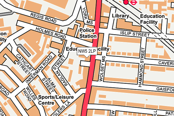
NW5 2LP is located in the Kentish Town South electoral ward, within the London borough of Camden and the English Parliamentary constituency of Holborn and St Pancras. The Sub Integrated Care Board (ICB) Location is NHS North Central London ICB - 93C and the police force is Metropolitan Police. This postcode has been in use since January 1980.


GetTheData
Source: OS OpenMap – Local (Ordnance Survey)
Source: OS VectorMap District (Ordnance Survey)
Licence: Open Government Licence (requires attribution)
| Easting | 528969 |
| Northing | 184960 |
| Latitude | 51.548801 |
| Longitude | -0.141386 |
GetTheData
Source: Open Postcode Geo
Licence: Open Government Licence
| Country | England |
| Postcode District | NW5 |
| ➜ NW5 open data dashboard ➜ See where NW5 is on a map ➜ Where is London? | |
GetTheData
Source: Land Registry Price Paid Data
Licence: Open Government Licence
Elevation or altitude of NW5 2LP as distance above sea level:
| Metres | Feet | |
|---|---|---|
| Elevation | 40m | 131ft |
Elevation is measured from the approximate centre of the postcode, to the nearest point on an OS contour line from OS Terrain 50, which has contour spacing of ten vertical metres.
➜ How high above sea level am I? Find the elevation of your current position using your device's GPS.
GetTheData
Source: Open Postcode Elevation
Licence: Open Government Licence
| Ward | Kentish Town South |
| Constituency | Holborn And St Pancras |
GetTheData
Source: ONS Postcode Database
Licence: Open Government Licence
| January 2024 | Burglary | On or near Bartholomew Road | 439m |
| January 2024 | Criminal damage and arson | On or near Bartholomew Road | 439m |
| January 2024 | Violence and sexual offences | On or near Bartholomew Road | 439m |
| ➜ Get more crime data in our Crime section | |||
GetTheData
Source: data.police.uk
Licence: Open Government Licence
| Kentish Town Post Office (Kentish Town Road) | Kentish Town | 21m |
| Kentish Town Post Office (Kentish Town Road) | Kentish Town | 69m |
| Kentish Town (Kentish Town Road) | Kentish Town | 164m |
| Kentish Town Road (Prince Of Wales Road) | Kentish Town | 254m |
| Kentish Town | Kentish Town | 286m |
| Kentish Town Underground Station | Kentish Town | 174m |
| Tufnell Park Underground Station | Tufnell Park | 915m |
| Chalk Farm Underground Station | Chalk Farm | 982m |
| Camden Town Underground Station | Camden Town | 1,062m |
| Kentish Town Station | 0.2km |
| Kentish Town West Station | 0.4km |
| Camden Road Station | 0.8km |
GetTheData
Source: NaPTAN
Licence: Open Government Licence
GetTheData
Source: ONS Postcode Database
Licence: Open Government Licence


➜ Get more ratings from the Food Standards Agency
GetTheData
Source: Food Standards Agency
Licence: FSA terms & conditions
| Last Collection | |||
|---|---|---|---|
| Location | Mon-Fri | Sat | Distance |
| Kentish Town Post Office | 17:30 | 12:00 | 63m |
| 329 Kentish Town | 17:30 | 12:00 | 167m |
| Kentish Town Delivery Office | 18:00 | 12:00 | 250m |
GetTheData
Source: Dracos
Licence: Creative Commons Attribution-ShareAlike
| Facility | Distance |
|---|---|
| Kentish Town Sports Centre Grafton Road, London Swimming Pool, Health and Fitness Gym, Studio, Sports Hall | 275m |
| Our Lady Help Of Christians Lady Margaret Road, London Sports Hall | 403m |
| Talacre Community Sports Centre Dalby Street, London Sports Hall, Artificial Grass Pitch, Studio | 430m |
GetTheData
Source: Active Places
Licence: Open Government Licence
| School | Phase of Education | Distance |
|---|---|---|
| St Patrick's Catholic Primary School Holmes Road, London, NW5 3AH | Primary | 119m |
| Kentish Town Church of England Primary School Islip Street, London, NW5 2TU | Primary | 179m |
| College Francais Bilingue De Londres 87 Holmes Road, Kentish Town, London, NW5 3AX | Not applicable | 298m |
GetTheData
Source: Edubase
Licence: Open Government Licence
The below table lists the International Territorial Level (ITL) codes (formerly Nomenclature of Territorial Units for Statistics (NUTS) codes) and Local Administrative Units (LAU) codes for NW5 2LP:
| ITL 1 Code | Name |
|---|---|
| TLI | London |
| ITL 2 Code | Name |
| TLI3 | Inner London - West |
| ITL 3 Code | Name |
| TLI31 | Camden and City of London |
| LAU 1 Code | Name |
| E09000007 | Camden |
GetTheData
Source: ONS Postcode Directory
Licence: Open Government Licence
The below table lists the Census Output Area (OA), Lower Layer Super Output Area (LSOA), and Middle Layer Super Output Area (MSOA) for NW5 2LP:
| Code | Name | |
|---|---|---|
| OA | E00004568 | |
| LSOA | E01000922 | Camden 007E |
| MSOA | E02000172 | Camden 007 |
GetTheData
Source: ONS Postcode Directory
Licence: Open Government Licence
| NW5 2JS | Kentish Town Road | 0m |
| NW5 2JW | Old Dairy Mews | 21m |
| NW5 2JR | Crown Place | 40m |
| NW5 3AA | Holmes Road | 52m |
| NW5 2AB | Kentish Town Road | 55m |
| NW5 3BX | Raglan Street | 59m |
| NW5 2JT | Kentish Town Road | 59m |
| NW5 2DX | Wolsey Mews | 59m |
| NW5 3BU | Raglan Street | 64m |
| NW5 3BY | Raglan Street | 82m |
GetTheData
Source: Open Postcode Geo; Land Registry Price Paid Data
Licence: Open Government Licence