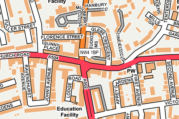
NW4 1BP is located in the Hendon electoral ward, within the London borough of Barnet and the English Parliamentary constituency of Hendon. The Sub Integrated Care Board (ICB) Location is NHS North Central London ICB - 93C and the police force is Metropolitan Police. This postcode has been in use since January 1980.


GetTheData
Source: OS OpenMap – Local (Ordnance Survey)
Source: OS VectorMap District (Ordnance Survey)
Licence: Open Government Licence (requires attribution)
| Easting | 523317 |
| Northing | 189383 |
| Latitude | 51.589813 |
| Longitude | -0.221306 |
GetTheData
Source: Open Postcode Geo
Licence: Open Government Licence
| Country | England |
| Postcode District | NW4 |
| ➜ NW4 open data dashboard ➜ See where NW4 is on a map ➜ Where is Hendon? | |
GetTheData
Source: Land Registry Price Paid Data
Licence: Open Government Licence
Elevation or altitude of NW4 1BP as distance above sea level:
| Metres | Feet | |
|---|---|---|
| Elevation | 70m | 230ft |
Elevation is measured from the approximate centre of the postcode, to the nearest point on an OS contour line from OS Terrain 50, which has contour spacing of ten vertical metres.
➜ How high above sea level am I? Find the elevation of your current position using your device's GPS.
GetTheData
Source: Open Postcode Elevation
Licence: Open Government Licence
| Ward | Hendon |
| Constituency | Hendon |
GetTheData
Source: ONS Postcode Database
Licence: Open Government Licence
| January 2024 | Robbery | On or near Linfield Close | 127m |
| January 2024 | Anti-social behaviour | On or near Brampton Lane | 267m |
| January 2024 | Burglary | On or near Brampton Lane | 267m |
| ➜ Get more crime data in our Crime section | |||
GetTheData
Source: data.police.uk
Licence: Open Government Licence
| The Quadrant Hendon | Hendon | 40m |
| The Quadrant Hendon | Hendon | 50m |
| The Quadrant Hendon | Hendon | 57m |
| Florence Street | Hendon | 80m |
| The Quadrant Hendon (Brent Street) | Hendon | 93m |
| Hendon Central Underground Station | Hendon Central | 807m |
| Brent Cross Underground Station | Brent Cross | 1,558m |
| Hendon Station | 1.6km |
| Mill Hill Broadway Station | 3.2km |
| Cricklewood Station | 3.5km |
GetTheData
Source: NaPTAN
Licence: Open Government Licence
GetTheData
Source: ONS Postcode Database
Licence: Open Government Licence


➜ Get more ratings from the Food Standards Agency
GetTheData
Source: Food Standards Agency
Licence: FSA terms & conditions
| Last Collection | |||
|---|---|---|---|
| Location | Mon-Fri | Sat | Distance |
| 200 Brent Street | 17:30 | 12:00 | 40m |
| Hendon Post Office | 18:00 | 12:00 | 192m |
| Victoria Road | 17:30 | 12:00 | 289m |
GetTheData
Source: Dracos
Licence: Creative Commons Attribution-ShareAlike
| Facility | Distance |
|---|---|
| Nautilus Health Club Hendon (Closed) Victoria Road, London Health and Fitness Gym | 236m |
| St Mary's C Of E High School (Closed) Downage, London Sports Hall | 291m |
| Mr Fitta Health Club Sentinel Square, London Health and Fitness Gym | 301m |
GetTheData
Source: Active Places
Licence: Open Government Licence
| School | Phase of Education | Distance |
|---|---|---|
| Brampton College Lodge House, Lodge Road, Hendon, London, NW4 4DQ | Not applicable | 145m |
| Nancy Reuben Primary School 48 Finchley Lane, Hendon, London, NW4 1DJ | Not applicable | 239m |
| Kisharon College 54 Parson Street, Hendon, London, NW4 1TP | Not applicable | 303m |
GetTheData
Source: Edubase
Licence: Open Government Licence
The below table lists the International Territorial Level (ITL) codes (formerly Nomenclature of Territorial Units for Statistics (NUTS) codes) and Local Administrative Units (LAU) codes for NW4 1BP:
| ITL 1 Code | Name |
|---|---|
| TLI | London |
| ITL 2 Code | Name |
| TLI7 | Outer London - West and North West |
| ITL 3 Code | Name |
| TLI71 | Barnet |
| LAU 1 Code | Name |
| E09000003 | Barnet |
GetTheData
Source: ONS Postcode Directory
Licence: Open Government Licence
The below table lists the Census Output Area (OA), Lower Layer Super Output Area (LSOA), and Middle Layer Super Output Area (MSOA) for NW4 1BP:
| Code | Name | |
|---|---|---|
| OA | E00001199 | |
| LSOA | E01000243 | Barnet 032C |
| MSOA | E02000055 | Barnet 032 |
GetTheData
Source: ONS Postcode Directory
Licence: Open Government Licence
| NW4 1BN | Finchley Lane | 26m |
| NW4 1QB | Parson Street | 44m |
| NW4 1DP | Finchley Lane | 47m |
| NW4 4DH | Brent Street | 59m |
| NW4 4DT | Church Road | 66m |
| NW4 1QD | Parson Street | 69m |
| NW4 1BT | Glebe Crescent | 73m |
| NW4 1BX | Finchley Lane | 85m |
| NW4 4EW | Church Road | 95m |
| NW4 1QG | Florence Street | 101m |
GetTheData
Source: Open Postcode Geo; Land Registry Price Paid Data
Licence: Open Government Licence