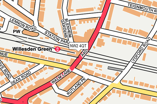
NW2 4QT is located in the Willesden Green electoral ward, within the London borough of Brent and the English Parliamentary constituency of Brent Central. The Sub Integrated Care Board (ICB) Location is NHS North West London ICB - W2U3Z and the police force is Metropolitan Police. This postcode has been in use since January 1980.


GetTheData
Source: OS OpenMap – Local (Ordnance Survey)
Source: OS VectorMap District (Ordnance Survey)
Licence: Open Government Licence (requires attribution)
| Easting | 523430 |
| Northing | 184865 |
| Latitude | 51.549185 |
| Longitude | -0.221261 |
GetTheData
Source: Open Postcode Geo
Licence: Open Government Licence
| Country | England |
| Postcode District | NW2 |
| ➜ NW2 open data dashboard ➜ See where NW2 is on a map ➜ Where is Willesden? | |
GetTheData
Source: Land Registry Price Paid Data
Licence: Open Government Licence
Elevation or altitude of NW2 4QT as distance above sea level:
| Metres | Feet | |
|---|---|---|
| Elevation | 50m | 164ft |
Elevation is measured from the approximate centre of the postcode, to the nearest point on an OS contour line from OS Terrain 50, which has contour spacing of ten vertical metres.
➜ How high above sea level am I? Find the elevation of your current position using your device's GPS.
GetTheData
Source: Open Postcode Elevation
Licence: Open Government Licence
| Ward | Willesden Green |
| Constituency | Brent Central |
GetTheData
Source: ONS Postcode Database
Licence: Open Government Licence
| December 2023 | Violence and sexual offences | On or near Ellis Close | 444m |
| November 2023 | Violence and sexual offences | On or near Ellis Close | 444m |
| October 2023 | Violence and sexual offences | On or near Ellis Close | 444m |
| ➜ Get more crime data in our Crime section | |||
GetTheData
Source: data.police.uk
Licence: Open Government Licence
| Willesden Green (Walm Lane) | Willesden Green | 27m |
| Willesden Green | Willesden Green | 29m |
| Willesden Green (Walm Lane) | Willesden Green | 38m |
| Willesden Lane (Walm Lane) | Willesden Green | 193m |
| Willesden Lane (Walm Lane) | Willesden Green | 236m |
| Willesden Green Underground Station | Willesden Green | 20m |
| Kilburn Underground Station | Brondesbury | 1,219m |
| Dollis Hill Underground Station | Dudden Hill | 1,273m |
| Cricklewood Station | 1.2km |
| Brondesbury Park Station | 1.2km |
| Brondesbury Station | 1.4km |
GetTheData
Source: NaPTAN
Licence: Open Government Licence
GetTheData
Source: ONS Postcode Database
Licence: Open Government Licence


➜ Get more ratings from the Food Standards Agency
GetTheData
Source: Food Standards Agency
Licence: FSA terms & conditions
| Last Collection | |||
|---|---|---|---|
| Location | Mon-Fri | Sat | Distance |
| Walm Lane Post Office | 18:30 | 12:00 | 88m |
| 18 Blenheim Gardens | 17:30 | 12:00 | 161m |
| Chatsworth Road | 17:30 | 12:00 | 178m |
GetTheData
Source: Dracos
Licence: Creative Commons Attribution-ShareAlike
| Facility | Distance |
|---|---|
| Nuffield Health (Brondesbury Park) Sidmouth Road, London Swimming Pool, Health and Fitness Gym, Studio | 475m |
| South Hampstead Tennis Club Milverton Road, Milverton Road, London Outdoor Tennis Courts | 505m |
| South Hampstead Cricket Club Milverton Road, London Grass Pitches | 643m |
GetTheData
Source: Active Places
Licence: Open Government Licence
| School | Phase of Education | Distance |
|---|---|---|
| Convent of Jesus and Mary RC Infant School 21 Park Avenue, London, NW2 5AN | Primary | 434m |
| Anson Primary School Anson Road, London, NW2 4AB | Primary | 512m |
| St Mary Magdalen's Catholic Junior School Linacre Road, Willesden Green, London, NW2 5BB | Primary | 528m |
GetTheData
Source: Edubase
Licence: Open Government Licence
The below table lists the International Territorial Level (ITL) codes (formerly Nomenclature of Territorial Units for Statistics (NUTS) codes) and Local Administrative Units (LAU) codes for NW2 4QT:
| ITL 1 Code | Name |
|---|---|
| TLI | London |
| ITL 2 Code | Name |
| TLI7 | Outer London - West and North West |
| ITL 3 Code | Name |
| TLI72 | Brent |
| LAU 1 Code | Name |
| E09000005 | Brent |
GetTheData
Source: ONS Postcode Directory
Licence: Open Government Licence
The below table lists the Census Output Area (OA), Lower Layer Super Output Area (LSOA), and Middle Layer Super Output Area (MSOA) for NW2 4QT:
| Code | Name | |
|---|---|---|
| OA | E00003104 | |
| LSOA | E01000642 | Brent 022D |
| MSOA | E02000114 | Brent 022 |
GetTheData
Source: ONS Postcode Directory
Licence: Open Government Licence
| NW2 4NH | Station Parade | 39m |
| NW2 4NN | Station Parade | 41m |
| NW2 4QU | Walm Lane | 48m |
| NW2 4QY | Walm Lane | 54m |
| NW2 4QA | Walm Lane | 64m |
| NW2 5SR | St Pauls Avenue | 68m |
| NW2 4NU | Station Parade | 80m |
| NW2 4QR | Walm Lane | 85m |
| NW2 4NL | Blenheim Gardens | 91m |
| NW2 5QS | Chatsworth Road | 108m |
GetTheData
Source: Open Postcode Geo; Land Registry Price Paid Data
Licence: Open Government Licence