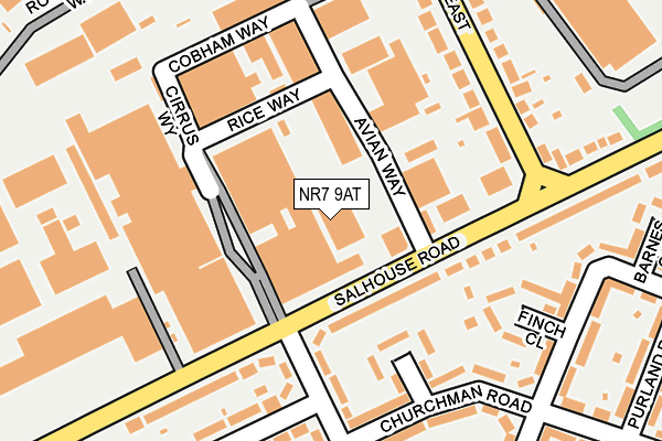
NR7 9AT is located in the Sprowston East electoral ward, within the local authority district of Broadland and the English Parliamentary constituency of Norwich North. The Sub Integrated Care Board (ICB) Location is NHS Norfolk and Waveney ICB - 26A and the police force is Norfolk. This postcode has been in use since July 2006.


GetTheData
Source: OS OpenMap – Local (Ordnance Survey)
Source: OS VectorMap District (Ordnance Survey)
Licence: Open Government Licence (requires attribution)
| Easting | 625202 |
| Northing | 310729 |
| Latitude | 52.647540 |
| Longitude | 1.327633 |
GetTheData
Source: Open Postcode Geo
Licence: Open Government Licence
| Country | England |
| Postcode District | NR7 |
| ➜ NR7 open data dashboard ➜ See where NR7 is on a map ➜ Where is Norwich? | |
GetTheData
Source: Land Registry Price Paid Data
Licence: Open Government Licence
Elevation or altitude of NR7 9AT as distance above sea level:
| Metres | Feet | |
|---|---|---|
| Elevation | 40m | 131ft |
Elevation is measured from the approximate centre of the postcode, to the nearest point on an OS contour line from OS Terrain 50, which has contour spacing of ten vertical metres.
➜ How high above sea level am I? Find the elevation of your current position using your device's GPS.
GetTheData
Source: Open Postcode Elevation
Licence: Open Government Licence
| Ward | Sprowston East |
| Constituency | Norwich North |
GetTheData
Source: ONS Postcode Database
Licence: Open Government Licence
| June 2022 | Shoplifting | On or near Sports/Recreation Area | 254m |
| June 2022 | Shoplifting | On or near Sports/Recreation Area | 254m |
| June 2022 | Violence and sexual offences | On or near Salhouse Road | 280m |
| ➜ Get more crime data in our Crime section | |||
GetTheData
Source: data.police.uk
Licence: Open Government Licence
| Deloney Road (Salhouse Road) | Heartsease | 168m |
| High School (Salhouse Road) | Heartsease | 182m |
| Deloney Road (Salhouse Road) | Heartsease | 186m |
| Retail Park (Salhouse Road) | Heartsease | 261m |
| Williamson Close (Churchman Road) | Heartsease | 263m |
| Norwich Station | 2.7km |
| Salhouse Station | 5.3km |
GetTheData
Source: NaPTAN
Licence: Open Government Licence
GetTheData
Source: ONS Postcode Database
Licence: Open Government Licence


➜ Get more ratings from the Food Standards Agency
GetTheData
Source: Food Standards Agency
Licence: FSA terms & conditions
| Last Collection | |||
|---|---|---|---|
| Location | Mon-Fri | Sat | Distance |
| Heartsease Post Office | 18:00 | 11:00 | 389m |
| Salhouse Road East | 18:00 | 11:00 | 416m |
| Blithewood Gardens | 17:30 | 11:00 | 646m |
GetTheData
Source: Dracos
Licence: Creative Commons Attribution-ShareAlike
| Facility | Distance |
|---|---|
| The Arena (Norwich) Avian Way, Salhouse Road, Salhouse Road, Norwich Artificial Grass Pitch | 177m |
| Open Academy (Closed) Marryat Road, Norwich Grass Pitches, Sports Hall | 296m |
| Open Academy Salhouse Road, Norwich Sports Hall, Studio, Grass Pitches, Outdoor Tennis Courts, Artificial Grass Pitch | 363m |
GetTheData
Source: Active Places
Licence: Open Government Licence
| School | Phase of Education | Distance |
|---|---|---|
| The Open Academy Salhouse Road, Norwich, NR7 9DL | Secondary | 358m |
| Falcon Junior School Falcon Road West, Sprowston, Norwich, NR7 8NT | Primary | 427m |
| Sprowston Community Academy Cannerby Lane, Sprowston, Norwich, NR7 8NE | Secondary | 511m |
GetTheData
Source: Edubase
Licence: Open Government Licence
The below table lists the International Territorial Level (ITL) codes (formerly Nomenclature of Territorial Units for Statistics (NUTS) codes) and Local Administrative Units (LAU) codes for NR7 9AT:
| ITL 1 Code | Name |
|---|---|
| TLH | East |
| ITL 2 Code | Name |
| TLH1 | East Anglia |
| ITL 3 Code | Name |
| TLH15 | Norwich and East Norfolk |
| LAU 1 Code | Name |
| E07000144 | Broadland |
GetTheData
Source: ONS Postcode Directory
Licence: Open Government Licence
The below table lists the Census Output Area (OA), Lower Layer Super Output Area (LSOA), and Middle Layer Super Output Area (MSOA) for NR7 9AT:
| Code | Name | |
|---|---|---|
| OA | E00134959 | |
| LSOA | E01026559 | Broadland 013C |
| MSOA | E02005532 | Broadland 013 |
GetTheData
Source: ONS Postcode Directory
Licence: Open Government Licence
| NR7 9DL | Salhouse Road | 163m |
| NR7 9DJ | Deloney Road | 194m |
| NR7 9DN | Salhouse Road | 224m |
| NR7 9DF | Marryat Road | 227m |
| NR7 9DT | Williamson Close | 248m |
| NR7 9DD | Kempe Close | 281m |
| NR7 9DQ | Deloney Road | 287m |
| NR7 8XZ | Falcon Road East | 288m |
| NR7 9DP | Churchman Road | 292m |
| NR7 9DX | Finch Close | 332m |
GetTheData
Source: Open Postcode Geo; Land Registry Price Paid Data
Licence: Open Government Licence