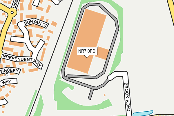
NR7 0FD is located in the Thorpe St Andrew South East electoral ward, within the local authority district of Broadland and the English Parliamentary constituency of Norwich North. The Sub Integrated Care Board (ICB) Location is NHS Norfolk and Waveney ICB - 26A and the police force is Norfolk. This postcode has been in use since September 2009.


GetTheData
Source: OS OpenMap – Local (Ordnance Survey)
Source: OS VectorMap District (Ordnance Survey)
Licence: Open Government Licence (requires attribution)
| Easting | 628184 |
| Northing | 309688 |
| Latitude | 52.636928 |
| Longitude | 1.370890 |
GetTheData
Source: Open Postcode Geo
Licence: Open Government Licence
| Country | England |
| Postcode District | NR7 |
| ➜ NR7 open data dashboard ➜ See where NR7 is on a map ➜ Where is Norwich? | |
GetTheData
Source: Land Registry Price Paid Data
Licence: Open Government Licence
Elevation or altitude of NR7 0FD as distance above sea level:
| Metres | Feet | |
|---|---|---|
| Elevation | 20m | 66ft |
Elevation is measured from the approximate centre of the postcode, to the nearest point on an OS contour line from OS Terrain 50, which has contour spacing of ten vertical metres.
➜ How high above sea level am I? Find the elevation of your current position using your device's GPS.
GetTheData
Source: Open Postcode Elevation
Licence: Open Government Licence
| Ward | Thorpe St Andrew South East |
| Constituency | Norwich North |
GetTheData
Source: ONS Postcode Database
Licence: Open Government Licence
| July 2022 | Violence and sexual offences | On or near Cornet Close | 424m |
| June 2022 | Criminal damage and arson | On or near Independent Way | 227m |
| June 2022 | Violence and sexual offences | On or near Newbury Way | 330m |
| ➜ Get more crime data in our Crime section | |||
GetTheData
Source: data.police.uk
Licence: Open Government Licence
| Post Box (Dussindale Drive) | Dussindale Park | 294m |
| Post Box (Dussindale Drive) | Dussindale Park | 309m |
| Naseby Way (Dussindale Drive) | Dussindale Park | 474m |
| Royalist Drive (Dussindale Drive) | Dussindale Park | 491m |
| Association Way (Dussindale Drive) | Dussindale Park | 494m |
| Brundall Gardens Station | 3.6km |
| Norwich Station | 4.5km |
| Salhouse Station | 4.5km |
GetTheData
Source: NaPTAN
Licence: Open Government Licence
GetTheData
Source: ONS Postcode Database
Licence: Open Government Licence


➜ Get more ratings from the Food Standards Agency
GetTheData
Source: Food Standards Agency
Licence: FSA terms & conditions
| Last Collection | |||
|---|---|---|---|
| Location | Mon-Fri | Sat | Distance |
| Dussingdale Road | 17:30 | 11:00 | 297m |
| Laundry Lane | 17:30 | 11:00 | 901m |
| Eastern Crescent | 17:30 | 11:00 | 975m |
GetTheData
Source: Dracos
Licence: Creative Commons Attribution-ShareAlike
| Facility | Distance |
|---|---|
| Fitzmaurice Park Pound Lane, Thorpe St Andrew, Norwich Outdoor Tennis Courts, Grass Pitches | 684m |
| Bannatyne Health Club (Norwich) Northside, St. Andrews Business Park, Norwich Swimming Pool, Health and Fitness Gym, Indoor Tennis Centre, Studio, Squash Courts, Outdoor Tennis Courts | 819m |
| Oasis Sports & Leisure Club (Thorpe) (Closed) Pound Lane, Norwich Swimming Pool, Health and Fitness Gym, Studio, Squash Courts, Outdoor Tennis Courts | 867m |
GetTheData
Source: Active Places
Licence: Open Government Licence
| School | Phase of Education | Distance |
|---|---|---|
| Dussindale Primary School Vane Close, Thorpe St Andrew, Norwich, NR7 0US | Primary | 762m |
| Thorpe St Andrew School and Sixth Form Laundry Lane, Thorpe St Andrew, Norwich, NR7 0XS | Secondary | 1km |
| Hillside Avenue Primary and Nursery School, Thorpe Hillside Avenue, Thorpe St Andrew, Norwich, NR7 0QW | Primary | 1.6km |
GetTheData
Source: Edubase
Licence: Open Government Licence
The below table lists the International Territorial Level (ITL) codes (formerly Nomenclature of Territorial Units for Statistics (NUTS) codes) and Local Administrative Units (LAU) codes for NR7 0FD:
| ITL 1 Code | Name |
|---|---|
| TLH | East |
| ITL 2 Code | Name |
| TLH1 | East Anglia |
| ITL 3 Code | Name |
| TLH15 | Norwich and East Norfolk |
| LAU 1 Code | Name |
| E07000144 | Broadland |
GetTheData
Source: ONS Postcode Directory
Licence: Open Government Licence
The below table lists the Census Output Area (OA), Lower Layer Super Output Area (LSOA), and Middle Layer Super Output Area (MSOA) for NR7 0FD:
| Code | Name | |
|---|---|---|
| OA | E00135029 | |
| LSOA | E01026576 | Broadland 016C |
| MSOA | E02005535 | Broadland 016 |
GetTheData
Source: ONS Postcode Directory
Licence: Open Government Licence
| NR7 0UY | Edgehill | 149m |
| NR7 0UX | Independent Way | 221m |
| NR7 0UZ | Bunyan Close | 222m |
| NR7 0RP | Dalbier Close | 258m |
| NR7 0NS | Winceby Close | 267m |
| NR7 0RS | Maidens Close | 318m |
| NR7 0NP | Chalgrove Field | 325m |
| NR7 0TY | Saker Close | 328m |
| NR7 0YQ | Newbury Way | 328m |
| NR7 0RR | Desborough Way | 356m |
GetTheData
Source: Open Postcode Geo; Land Registry Price Paid Data
Licence: Open Government Licence