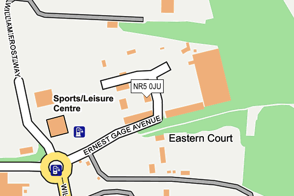
NR5 0JU is located in the Old Costessey electoral ward, within the local authority district of South Norfolk and the English Parliamentary constituency of South Norfolk. The Sub Integrated Care Board (ICB) Location is NHS Norfolk and Waveney ICB - 26A and the police force is Norfolk. This postcode has been in use since January 2006.


GetTheData
Source: OS OpenMap – Local (Ordnance Survey)
Source: OS VectorMap District (Ordnance Survey)
Licence: Open Government Licence (requires attribution)
| Easting | 615759 |
| Northing | 311103 |
| Latitude | 52.654707 |
| Longitude | 1.188504 |
GetTheData
Source: Open Postcode Geo
Licence: Open Government Licence
| Country | England |
| Postcode District | NR5 |
| ➜ NR5 open data dashboard ➜ See where NR5 is on a map | |
GetTheData
Source: Land Registry Price Paid Data
Licence: Open Government Licence
Elevation or altitude of NR5 0JU as distance above sea level:
| Metres | Feet | |
|---|---|---|
| Elevation | 30m | 98ft |
Elevation is measured from the approximate centre of the postcode, to the nearest point on an OS contour line from OS Terrain 50, which has contour spacing of ten vertical metres.
➜ How high above sea level am I? Find the elevation of your current position using your device's GPS.
GetTheData
Source: Open Postcode Elevation
Licence: Open Government Licence
| Ward | Old Costessey |
| Constituency | South Norfolk |
GetTheData
Source: ONS Postcode Database
Licence: Open Government Licence
| June 2022 | Anti-social behaviour | On or near Ernest Gage Avenue | 167m |
| June 2022 | Public order | On or near William Frost Way | 255m |
| June 2022 | Criminal damage and arson | On or near William Frost Way | 255m |
| ➜ Get more crime data in our Crime section | |||
GetTheData
Source: data.police.uk
Licence: Open Government Licence
| Longwater Gravel (William Frost Way) | New Costessey | 294m |
| Mcdonalds (William Frost Way) | New Costessey | 301m |
| Link Road (Longwater) | New Costessey | 460m |
| Travel Inn (Easton Road) | New Costessey | 591m |
| Travel Inn (Easton Road) | New Costessey | 618m |
GetTheData
Source: NaPTAN
Licence: Open Government Licence
GetTheData
Source: ONS Postcode Database
Licence: Open Government Licence


➜ Get more ratings from the Food Standards Agency
GetTheData
Source: Food Standards Agency
Licence: FSA terms & conditions
| Last Collection | |||
|---|---|---|---|
| Location | Mon-Fri | Sat | Distance |
| Longwater Lane | 18:00 | 11:00 | 1,317m |
| Ringland Lane | 16:45 | 11:00 | 1,421m |
| West End Post Office | 17:00 | 11:30 | 1,526m |
GetTheData
Source: Dracos
Licence: Creative Commons Attribution-ShareAlike
| Facility | Distance |
|---|---|
| Bannatyne Health Club (Norwich West) William Frost Way, Longwater Business Park, Norwich Swimming Pool, Health and Fitness Gym, Studio | 188m |
| Costessey Park Golf Club Parklands, Costessey, Norwich Golf | 697m |
| The Costessey Centre Longwater Lane, Costessey, Norwich Grass Pitches, Sports Hall | 1.2km |
GetTheData
Source: Active Places
Licence: Open Government Licence
| School | Phase of Education | Distance |
|---|---|---|
| Queen's Hill Primary School Kestrel Avenue, Queen's Hills, Costessey, Norwich, NR8 5FT | Primary | 1.3km |
| St Augustine's Catholic Primary School, Costessey Westend, Old Costessey, Norwich, NR8 5AG | Primary | 1.3km |
| Ormiston Victory Academy Middleton Crescent, Costessey, Norwich, NR5 0PX | Secondary | 1.6km |
GetTheData
Source: Edubase
Licence: Open Government Licence
The below table lists the International Territorial Level (ITL) codes (formerly Nomenclature of Territorial Units for Statistics (NUTS) codes) and Local Administrative Units (LAU) codes for NR5 0JU:
| ITL 1 Code | Name |
|---|---|
| TLH | East |
| ITL 2 Code | Name |
| TLH1 | East Anglia |
| ITL 3 Code | Name |
| TLH17 | Breckland and South Norfolk |
| LAU 1 Code | Name |
| E07000149 | South Norfolk |
GetTheData
Source: ONS Postcode Directory
Licence: Open Government Licence
The below table lists the Census Output Area (OA), Lower Layer Super Output Area (LSOA), and Middle Layer Super Output Area (MSOA) for NR5 0JU:
| Code | Name | |
|---|---|---|
| OA | E00174623 | |
| LSOA | E01033538 | South Norfolk 001G |
| MSOA | E02005597 | South Norfolk 001 |
GetTheData
Source: ONS Postcode Directory
Licence: Open Government Licence
| NR5 0JT | Alex Moorhouse Way | 538m |
| NR5 0UX | Colossus Way | 624m |
| NR5 0UY | Colossus Way | 679m |
| NR5 0UT | Britannia Way | 764m |
| NR8 5AX | Tower Hill | 787m |
| NR5 0UZ | Minotaur Way | 827m |
| NR8 5AY | Tower Close | 847m |
| NR5 0UW | Britannia Way | 869m |
| NR5 0JH | Forest Way | 871m |
| NR8 5AU | Tower Close | 898m |
GetTheData
Source: Open Postcode Geo; Land Registry Price Paid Data
Licence: Open Government Licence