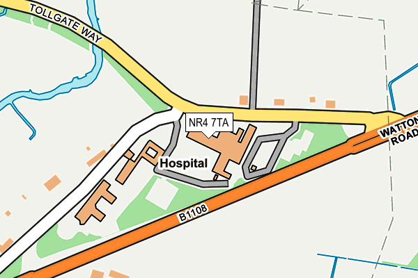
NR4 7TA is located in the Cringleford electoral ward, within the local authority district of South Norfolk and the English Parliamentary constituency of South Norfolk. The Sub Integrated Care Board (ICB) Location is NHS Norfolk and Waveney ICB - 26A and the police force is Norfolk. This postcode has been in use since July 1986.


GetTheData
Source: OS OpenMap – Local (Ordnance Survey)
Source: OS VectorMap District (Ordnance Survey)
Licence: Open Government Licence (requires attribution)
| Easting | 618415 |
| Northing | 308148 |
| Latitude | 52.627123 |
| Longitude | 1.225751 |
GetTheData
Source: Open Postcode Geo
Licence: Open Government Licence
| Country | England |
| Postcode District | NR4 |
| ➜ NR4 open data dashboard ➜ See where NR4 is on a map ➜ Where is Colney? | |
GetTheData
Source: Land Registry Price Paid Data
Licence: Open Government Licence
Elevation or altitude of NR4 7TA as distance above sea level:
| Metres | Feet | |
|---|---|---|
| Elevation | 20m | 66ft |
Elevation is measured from the approximate centre of the postcode, to the nearest point on an OS contour line from OS Terrain 50, which has contour spacing of ten vertical metres.
➜ How high above sea level am I? Find the elevation of your current position using your device's GPS.
GetTheData
Source: Open Postcode Elevation
Licence: Open Government Licence
| Ward | Cringleford |
| Constituency | South Norfolk |
GetTheData
Source: ONS Postcode Database
Licence: Open Government Licence
| June 2022 | Burglary | On or near Old Watton Road | 131m |
| June 2022 | Public order | On or near Old Watton Road | 131m |
| May 2022 | Public order | On or near Old Watton Road | 131m |
| ➜ Get more crime data in our Crime section | |||
GetTheData
Source: data.police.uk
Licence: Open Government Licence
| Hospital (Old Watton Road) | Colney | 77m |
| Hospital (Old Watton Road) | Colney | 84m |
| Old Watton Road (Watton Road) | Colney | 140m |
| Old Watton Road (Watton Road) | Colney | 150m |
| Church (Watton Road) | Colney | 211m |
GetTheData
Source: NaPTAN
Licence: Open Government Licence
GetTheData
Source: ONS Postcode Database
Licence: Open Government Licence


➜ Get more ratings from the Food Standards Agency
GetTheData
Source: Food Standards Agency
Licence: FSA terms & conditions
| Last Collection | |||
|---|---|---|---|
| Location | Mon-Fri | Sat | Distance |
| Old Watton Road | 17:30 | 08:15 | 165m |
| Dodderman Way | 17:30 | 11:00 | 537m |
| Wilberforce Road | 17:30 | 11:00 | 845m |
GetTheData
Source: Dracos
Licence: Creative Commons Attribution-ShareAlike
| Facility | Distance |
|---|---|
| University Of East Anglia Sports Ground Colney Lane, Colney, Norwich Grass Pitches | 587m |
| Sportspark At Uea University Drive, Norwich Sports Hall, Athletics, Swimming Pool, Health and Fitness Gym, Artificial Grass Pitch, Grass Pitches, Studio, Squash Courts, Outdoor Tennis Courts | 1.1km |
| City Academy Norwich Bluebell Road, Norwich Health and Fitness Gym, Swimming Pool, Grass Pitches, Sports Hall, Studio | 1.4km |
GetTheData
Source: Active Places
Licence: Open Government Licence
| School | Phase of Education | Distance |
|---|---|---|
| University of East Anglia The Registry, University Plain, Norwich, NR4 7TJ | Not applicable | 1.2km |
| West Earlham Infant and Nursery School Scarnell Road, Norwich, NR5 8HT | Primary | 1.2km |
| West Earlham Junior School Scarnell Road, Norwich, NR5 8HT | Primary | 1.2km |
GetTheData
Source: Edubase
Licence: Open Government Licence
The below table lists the International Territorial Level (ITL) codes (formerly Nomenclature of Territorial Units for Statistics (NUTS) codes) and Local Administrative Units (LAU) codes for NR4 7TA:
| ITL 1 Code | Name |
|---|---|
| TLH | East |
| ITL 2 Code | Name |
| TLH1 | East Anglia |
| ITL 3 Code | Name |
| TLH17 | Breckland and South Norfolk |
| LAU 1 Code | Name |
| E07000149 | South Norfolk |
GetTheData
Source: ONS Postcode Directory
Licence: Open Government Licence
The below table lists the Census Output Area (OA), Lower Layer Super Output Area (LSOA), and Middle Layer Super Output Area (MSOA) for NR4 7TA:
| Code | Name | |
|---|---|---|
| OA | E00136729 | |
| LSOA | E01026883 | South Norfolk 002C |
| MSOA | E02005598 | South Norfolk 002 |
GetTheData
Source: ONS Postcode Directory
Licence: Open Government Licence
| NR4 7TN | Old Watton Road | 158m |
| NR4 7TW | Old Watton Road | 174m |
| NR5 9HR | Thistle Close | 530m |
| NR5 9HX | Swallow Tail Close | 544m |
| NR5 9JQ | Buttercup Way | 581m |
| NR5 9HP | Speedwell Way | 585m |
| NR4 7TX | Watton Road | 588m |
| NR5 9PJ | Mavish Close | 593m |
| NR5 9HU | Mardle Street | 625m |
| NR5 9HG | The Runnel | 634m |
GetTheData
Source: Open Postcode Geo; Land Registry Price Paid Data
Licence: Open Government Licence