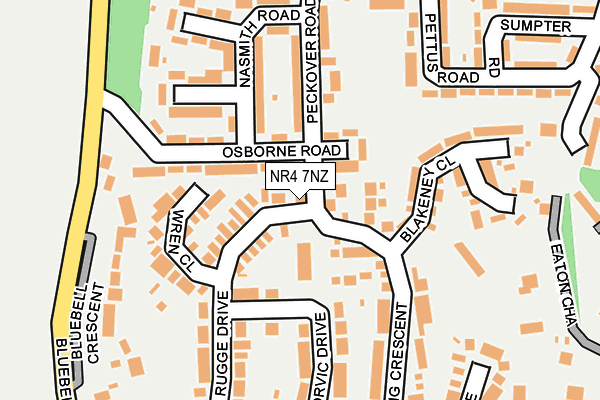
NR4 7NZ lies on Leng Crescent in Norwich. NR4 7NZ is located in the Eaton electoral ward, within the local authority district of Norwich and the English Parliamentary constituency of Norwich South. The Sub Integrated Care Board (ICB) Location is NHS Norfolk and Waveney ICB - 26A and the police force is Norfolk. This postcode has been in use since January 1980.


GetTheData
Source: OS OpenMap – Local (Ordnance Survey)
Source: OS VectorMap District (Ordnance Survey)
Licence: Open Government Licence (requires attribution)
| Easting | 620172 |
| Northing | 306839 |
| Latitude | 52.614665 |
| Longitude | 1.250795 |
GetTheData
Source: Open Postcode Geo
Licence: Open Government Licence
| Street | Leng Crescent |
| Town/City | Norwich |
| Country | England |
| Postcode District | NR4 |
| ➜ NR4 open data dashboard ➜ See where NR4 is on a map ➜ Where is Norwich? | |
GetTheData
Source: Land Registry Price Paid Data
Licence: Open Government Licence
Elevation or altitude of NR4 7NZ as distance above sea level:
| Metres | Feet | |
|---|---|---|
| Elevation | 20m | 66ft |
Elevation is measured from the approximate centre of the postcode, to the nearest point on an OS contour line from OS Terrain 50, which has contour spacing of ten vertical metres.
➜ How high above sea level am I? Find the elevation of your current position using your device's GPS.
GetTheData
Source: Open Postcode Elevation
Licence: Open Government Licence
| Ward | Eaton |
| Constituency | Norwich South |
GetTheData
Source: ONS Postcode Database
Licence: Open Government Licence
| December 2023 | Violence and sexual offences | On or near Hurd Road | 383m |
| December 2023 | Violence and sexual offences | On or near Hurd Road | 383m |
| December 2023 | Criminal damage and arson | On or near Hurd Road | 383m |
| ➜ Leng Crescent crime map and outcomes | |||
GetTheData
Source: data.police.uk
Licence: Open Government Licence
| Rugge Drive | Eaton Park | 107m |
| Peckover Road | Eaton Park | 166m |
| Leng Crescent (Norvic Drive) | Eaton Park | 294m |
| Norgate Road (Pettus Road) | Eaton Park | 302m |
| Custance Court (South Park Avenue) | Eaton Park | 335m |
| Norwich Station | 4km |
GetTheData
Source: NaPTAN
Licence: Open Government Licence
| Percentage of properties with Next Generation Access | 100.0% |
| Percentage of properties with Superfast Broadband | 100.0% |
| Percentage of properties with Ultrafast Broadband | 100.0% |
| Percentage of properties with Full Fibre Broadband | 0.0% |
Superfast Broadband is between 30Mbps and 300Mbps
Ultrafast Broadband is > 300Mbps
| Percentage of properties unable to receive 2Mbps | 0.0% |
| Percentage of properties unable to receive 5Mbps | 0.0% |
| Percentage of properties unable to receive 10Mbps | 0.0% |
| Percentage of properties unable to receive 30Mbps | 0.0% |
GetTheData
Source: Ofcom
Licence: Ofcom Terms of Use (requires attribution)
GetTheData
Source: ONS Postcode Database
Licence: Open Government Licence

➜ Get more ratings from the Food Standards Agency
GetTheData
Source: Food Standards Agency
Licence: FSA terms & conditions
| Last Collection | |||
|---|---|---|---|
| Location | Mon-Fri | Sat | Distance |
| Peckover Road | 17:45 | 11:00 | 206m |
| Norvic Drive | 17:45 | 11:00 | 300m |
| Pettus Road | 17:40 | 11:00 | 319m |
GetTheData
Source: Dracos
Licence: Creative Commons Attribution-ShareAlike
| Facility | Distance |
|---|---|
| Norfolk Bowling Club 444a Unthank Road, Norwich Indoor Bowls | 520m |
| Eaton Park South Park Avenue, Norwich Grass Pitches, Outdoor Tennis Courts, Cycling | 651m |
| Eaton Primary School Duverlin Close, Norwich Grass Pitches | 1.2km |
GetTheData
Source: Active Places
Licence: Open Government Licence
| School | Phase of Education | Distance |
|---|---|---|
| Eaton Hall Specialist Academy Pettus Road, Norwich, NR4 7BU | Not applicable | 437m |
| Colman Junior School South Park Avenue, Norwich, NR4 7AU | Primary | 1km |
| Bluebell Primary School Lovelace Road, Norwich, NR4 7DS | Primary | 1.1km |
GetTheData
Source: Edubase
Licence: Open Government Licence
The below table lists the International Territorial Level (ITL) codes (formerly Nomenclature of Territorial Units for Statistics (NUTS) codes) and Local Administrative Units (LAU) codes for NR4 7NZ:
| ITL 1 Code | Name |
|---|---|
| TLH | East |
| ITL 2 Code | Name |
| TLH1 | East Anglia |
| ITL 3 Code | Name |
| TLH15 | Norwich and East Norfolk |
| LAU 1 Code | Name |
| E07000148 | Norwich |
GetTheData
Source: ONS Postcode Directory
Licence: Open Government Licence
The below table lists the Census Output Area (OA), Lower Layer Super Output Area (LSOA), and Middle Layer Super Output Area (MSOA) for NR4 7NZ:
| Code | Name | |
|---|---|---|
| OA | E00136338 | |
| LSOA | E01026810 | Norwich 012A |
| MSOA | E02005595 | Norwich 012 |
GetTheData
Source: ONS Postcode Directory
Licence: Open Government Licence
| NR4 7NH | Chalfont Walk | 58m |
| NR4 7NP | Rugge Drive | 63m |
| NR4 7BW | Osborne Road | 78m |
| NR4 7BN | Osborne Road | 97m |
| NR4 7NW | Norvic Drive | 105m |
| NR4 7NR | Wren Close | 117m |
| NR4 7BH | Nasmith Road | 128m |
| NR4 7NY | Leng Crescent | 137m |
| NR4 7BP | Peckover Road | 141m |
| NR4 7QP | Blakeney Close | 163m |
GetTheData
Source: Open Postcode Geo; Land Registry Price Paid Data
Licence: Open Government Licence