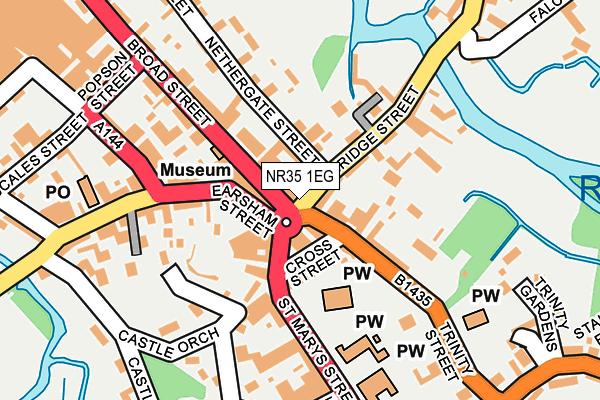
NR35 1EG lies on Market Place in Bungay. NR35 1EG is located in the Bungay & Wainford electoral ward, within the local authority district of East Suffolk and the English Parliamentary constituency of Waveney. The Sub Integrated Care Board (ICB) Location is NHS Norfolk and Waveney ICB - 26A and the police force is Suffolk. This postcode has been in use since January 1980.


GetTheData
Source: OS OpenMap – Local (Ordnance Survey)
Source: OS VectorMap District (Ordnance Survey)
Licence: Open Government Licence (requires attribution)
| Easting | 633646 |
| Northing | 289831 |
| Latitude | 52.456418 |
| Longitude | 1.437491 |
GetTheData
Source: Open Postcode Geo
Licence: Open Government Licence
| Street | Market Place |
| Town/City | Bungay |
| Country | England |
| Postcode District | NR35 |
| ➜ NR35 open data dashboard ➜ See where NR35 is on a map ➜ Where is Bungay? | |
GetTheData
Source: Land Registry Price Paid Data
Licence: Open Government Licence
Elevation or altitude of NR35 1EG as distance above sea level:
| Metres | Feet | |
|---|---|---|
| Elevation | 10m | 33ft |
Elevation is measured from the approximate centre of the postcode, to the nearest point on an OS contour line from OS Terrain 50, which has contour spacing of ten vertical metres.
➜ How high above sea level am I? Find the elevation of your current position using your device's GPS.
GetTheData
Source: Open Postcode Elevation
Licence: Open Government Licence
| Ward | Bungay & Wainford |
| Constituency | Waveney |
GetTheData
Source: ONS Postcode Database
Licence: Open Government Licence
| January 2024 | Criminal damage and arson | On or near Nethergate Street | 203m |
| November 2023 | Violence and sexual offences | On or near Nethergate Street | 203m |
| October 2023 | Violence and sexual offences | On or near Parking Area | 377m |
| ➜ Market Place crime map and outcomes | |||
GetTheData
Source: data.police.uk
Licence: Open Government Licence
| Cork Bricks (Earsham Street) | Bungay | 66m |
| Butter Cross (St Marys Street) | Bungay | 89m |
| Butter Cross (St Marys Street) | Bungay | 104m |
| Holy Trinity Church (Trinity Street) | Bungay | 150m |
| Chaucer Street (Earsham Street) | Bungay | 156m |
GetTheData
Source: NaPTAN
Licence: Open Government Licence
| Percentage of properties with Next Generation Access | 100.0% |
| Percentage of properties with Superfast Broadband | 100.0% |
| Percentage of properties with Ultrafast Broadband | 0.0% |
| Percentage of properties with Full Fibre Broadband | 0.0% |
Superfast Broadband is between 30Mbps and 300Mbps
Ultrafast Broadband is > 300Mbps
| Percentage of properties unable to receive 2Mbps | 0.0% |
| Percentage of properties unable to receive 5Mbps | 0.0% |
| Percentage of properties unable to receive 10Mbps | 0.0% |
| Percentage of properties unable to receive 30Mbps | 0.0% |
GetTheData
Source: Ofcom
Licence: Ofcom Terms of Use (requires attribution)
GetTheData
Source: ONS Postcode Database
Licence: Open Government Licence


➜ Get more ratings from the Food Standards Agency
GetTheData
Source: Food Standards Agency
Licence: FSA terms & conditions
| Last Collection | |||
|---|---|---|---|
| Location | Mon-Fri | Sat | Distance |
| St Mary Street | 17:30 | 12:00 | 103m |
| Royal Mail 42 Earsham Street | 18:00 | 12:15 | 215m |
| Bridge Street | 17:30 | 12:00 | 244m |
GetTheData
Source: Dracos
Licence: Creative Commons Attribution-ShareAlike
| Facility | Distance |
|---|---|
| Bodywise (Closed) Rose Lane, Bungay Health and Fitness Gym | 337m |
| Bungay & Waveney Valley Golf Club Outney Common, Bungay Golf | 623m |
| Maltings Meadow Pirnhow Street, Ditchingham, Bungay Grass Pitches, Artificial Grass Pitch | 1.2km |
GetTheData
Source: Active Places
Licence: Open Government Licence
| School | Phase of Education | Distance |
|---|---|---|
| St Edmund's Catholic Primary School St Mary's Street, Bungay, NR35 1AY | Primary | 200m |
| Bungay Primary School Wingfield Street, Bungay, NR35 1HA | Primary | 451m |
| Castle East School Hillside Road East, Bungay, NR35 1JS | Not applicable | 1.3km |
GetTheData
Source: Edubase
Licence: Open Government Licence
The below table lists the International Territorial Level (ITL) codes (formerly Nomenclature of Territorial Units for Statistics (NUTS) codes) and Local Administrative Units (LAU) codes for NR35 1EG:
| ITL 1 Code | Name |
|---|---|
| TLH | East |
| ITL 2 Code | Name |
| TLH1 | East Anglia |
| ITL 3 Code | Name |
| TLH14 | Suffolk CC |
| LAU 1 Code | Name |
| E07000244 | East Suffolk |
GetTheData
Source: ONS Postcode Directory
Licence: Open Government Licence
The below table lists the Census Output Area (OA), Lower Layer Super Output Area (LSOA), and Middle Layer Super Output Area (MSOA) for NR35 1EG:
| Code | Name | |
|---|---|---|
| OA | E00154189 | |
| LSOA | E01030230 | Waveney 013A |
| MSOA | E02006314 | Waveney 013 |
GetTheData
Source: ONS Postcode Directory
Licence: Open Government Licence
| NR35 1HB | Bridge Street | 12m |
| NR35 1EQ | Trinity Street | 42m |
| NR35 1AU | Cross Street | 65m |
| NR35 1AP | Market Place | 72m |
| NR35 1AW | Market Place | 73m |
| NR35 1AE | Earsham Street | 88m |
| NR35 1AG | Earsham Street | 93m |
| NR35 1HD | Bridge Street | 113m |
| NR35 1EE | Broad Street | 116m |
| NR35 1FD | Saxon Place | 145m |
GetTheData
Source: Open Postcode Geo; Land Registry Price Paid Data
Licence: Open Government Licence