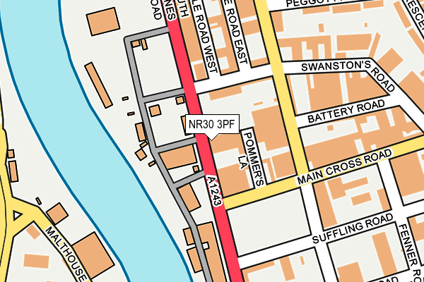
NR30 3PF is located in the Nelson electoral ward, within the local authority district of Great Yarmouth and the English Parliamentary constituency of Great Yarmouth. The Sub Integrated Care Board (ICB) Location is NHS Norfolk and Waveney ICB - 26A and the police force is Norfolk. This postcode has been in use since January 1980.


GetTheData
Source: OS OpenMap – Local (Ordnance Survey)
Source: OS VectorMap District (Ordnance Survey)
Licence: Open Government Licence (requires attribution)
| Easting | 652721 |
| Northing | 305782 |
| Latitude | 52.591055 |
| Longitude | 1.729766 |
GetTheData
Source: Open Postcode Geo
Licence: Open Government Licence
| Country | England |
| Postcode District | NR30 |
➜ See where NR30 is on a map ➜ Where is Great Yarmouth? | |
GetTheData
Source: Land Registry Price Paid Data
Licence: Open Government Licence
Elevation or altitude of NR30 3PF as distance above sea level:
| Metres | Feet | |
|---|---|---|
| Elevation | 0m | 0ft |
Elevation is measured from the approximate centre of the postcode, to the nearest point on an OS contour line from OS Terrain 50, which has contour spacing of ten vertical metres.
➜ How high above sea level am I? Find the elevation of your current position using your device's GPS.
GetTheData
Source: Open Postcode Elevation
Licence: Open Government Licence
| Ward | Nelson |
| Constituency | Great Yarmouth |
GetTheData
Source: ONS Postcode Database
Licence: Open Government Licence
| Battery Road (Admiralty Road) | Great Yarmouth | 137m |
| Peggotty Road (Admiralty Road) | Barrack Estate | 222m |
| Micawber Avenue (Peggotty Road) | Barrack Estate | 284m |
| Alpha Road (Beccles Road) | Gorleston | 297m |
| Alpha Road (Beccles Road) | Gorleston | 356m |
| Great Yarmouth Station | 2.4km |
GetTheData
Source: NaPTAN
Licence: Open Government Licence
GetTheData
Source: ONS Postcode Database
Licence: Open Government Licence


➜ Get more ratings from the Food Standards Agency
GetTheData
Source: Food Standards Agency
Licence: FSA terms & conditions
| Last Collection | |||
|---|---|---|---|
| Location | Mon-Fri | Sat | Distance |
| Beevor Road | 18:30 | 12:00 | 447m |
| Southtown Road | 17:00 | 12:00 | 562m |
| Suffolk Walk | 17:30 | 12:00 | 668m |
GetTheData
Source: Dracos
Licence: Creative Commons Attribution-ShareAlike
| Risk of NR30 3PF flooding from rivers and sea | Low |
| ➜ NR30 3PF flood map | |
GetTheData
Source: Open Flood Risk by Postcode
Licence: Open Government Licence
The below table lists the International Territorial Level (ITL) codes (formerly Nomenclature of Territorial Units for Statistics (NUTS) codes) and Local Administrative Units (LAU) codes for NR30 3PF:
| ITL 1 Code | Name |
|---|---|
| TLH | East |
| ITL 2 Code | Name |
| TLH1 | East Anglia |
| ITL 3 Code | Name |
| TLH15 | Norwich and East Norfolk |
| LAU 1 Code | Name |
| E07000145 | Great Yarmouth |
GetTheData
Source: ONS Postcode Directory
Licence: Open Government Licence
The below table lists the Census Output Area (OA), Lower Layer Super Output Area (LSOA), and Middle Layer Super Output Area (MSOA) for NR30 3PF:
| Code | Name | |
|---|---|---|
| OA | E00135303 | |
| LSOA | E01026622 | Great Yarmouth 006A |
| MSOA | E02005543 | Great Yarmouth 006 |
GetTheData
Source: ONS Postcode Directory
Licence: Open Government Licence
| NR30 3NQ | Swanstons Road | 195m |
| NR30 3EA | Peggotty Road | 235m |
| NR30 3NZ | Main Cross Road | 243m |
| NR30 3EF | Peggotty Road | 271m |
| NR30 3DX | Admiralty Road | 302m |
| NR30 3PU | Admiralty Road | 319m |
| NR30 3PA | Main Cross Road | 329m |
| NR31 0LF | Southtown Road | 330m |
| NR30 3EB | Copperfield Avenue | 334m |
| NR30 3EJ | South Beach Parade | 345m |
GetTheData
Source: Open Postcode Geo; Land Registry Price Paid Data
Licence: Open Government Licence