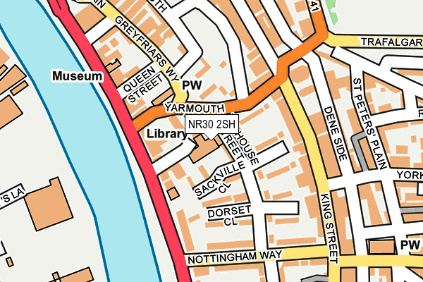
NR30 2SH is located in the Nelson electoral ward, within the local authority district of Great Yarmouth and the English Parliamentary constituency of Great Yarmouth. The Sub Integrated Care Board (ICB) Location is NHS Norfolk and Waveney ICB - 26A and the police force is Norfolk. This postcode has been in use since January 1980.


GetTheData
Source: OS OpenMap – Local (Ordnance Survey)
Source: OS VectorMap District (Ordnance Survey)
Licence: Open Government Licence (requires attribution)
| Easting | 652487 |
| Northing | 307250 |
| Latitude | 52.604307 |
| Longitude | 1.727415 |
GetTheData
Source: Open Postcode Geo
Licence: Open Government Licence
| Country | England |
| Postcode District | NR30 |
| ➜ NR30 open data dashboard ➜ See where NR30 is on a map ➜ Where is Great Yarmouth? | |
GetTheData
Source: Land Registry Price Paid Data
Licence: Open Government Licence
Elevation or altitude of NR30 2SH as distance above sea level:
| Metres | Feet | |
|---|---|---|
| Elevation | 0m | 0ft |
Elevation is measured from the approximate centre of the postcode, to the nearest point on an OS contour line from OS Terrain 50, which has contour spacing of ten vertical metres.
➜ How high above sea level am I? Find the elevation of your current position using your device's GPS.
GetTheData
Source: Open Postcode Elevation
Licence: Open Government Licence
| Ward | Nelson |
| Constituency | Great Yarmouth |
GetTheData
Source: ONS Postcode Database
Licence: Open Government Licence
| January 2024 | Public order | On or near Victoria Road | 465m |
| January 2024 | Violence and sexual offences | On or near Victoria Road | 465m |
| January 2024 | Violence and sexual offences | On or near Victoria Road | 465m |
| ➜ Get more crime data in our Crime section | |||
GetTheData
Source: data.police.uk
Licence: Open Government Licence
| St Georges Theatre (King Street) | Great Yarmouth | 138m |
| St Georges Theatre (Deneside) | Great Yarmouth | 171m |
| King Street Surgery (King Street) | Great Yarmouth | 219m |
| Lancaster Road (Deneside) | Great Yarmouth | 252m |
| Regents Road (Deneside) | Great Yarmouth | 275m |
| Great Yarmouth Station | 1km |
GetTheData
Source: NaPTAN
Licence: Open Government Licence
GetTheData
Source: ONS Postcode Database
Licence: Open Government Licence


➜ Get more ratings from the Food Standards Agency
GetTheData
Source: Food Standards Agency
Licence: FSA terms & conditions
| Last Collection | |||
|---|---|---|---|
| Location | Mon-Fri | Sat | Distance |
| Gt Yarmouth Library | 17:00 | 11:30 | 16m |
| St Georges Plain | 17:30 | 11:30 | 143m |
| Nottingham Way | 17:00 | 11:30 | 166m |
GetTheData
Source: Dracos
Licence: Creative Commons Attribution-ShareAlike
| Facility | Distance |
|---|---|
| York Road Drill Hall (Closed) York Road, Great Yarmouth Sports Hall | 232m |
| Legends Fitness Academy Steam Mill Lane, Cobholm, Near Haven Bridge, Great Yarmouth Studio, Health and Fitness Gym | 479m |
| The Gym Group (Great Yarmouth) Pasteur Road, Great Yarmouth Health and Fitness Gym | 604m |
GetTheData
Source: Active Places
Licence: Open Government Licence
| School | Phase of Education | Distance |
|---|---|---|
| St George's Primary School & St. George's Nursery School, Great Yarmouth St Peter's Road, Great Yarmouth, NR30 3BQ | Primary | 480m |
| St Nicholas Priory CofE VA Primary School St Nicholas Road, Great Yarmouth, NR30 1NL | Primary | 724m |
| Southtown Primary School Tamworth Lane, Southtown, Great Yarmouth, NR31 0HJ | Primary | 749m |
GetTheData
Source: Edubase
Licence: Open Government Licence
The below table lists the International Territorial Level (ITL) codes (formerly Nomenclature of Territorial Units for Statistics (NUTS) codes) and Local Administrative Units (LAU) codes for NR30 2SH:
| ITL 1 Code | Name |
|---|---|
| TLH | East |
| ITL 2 Code | Name |
| TLH1 | East Anglia |
| ITL 3 Code | Name |
| TLH15 | Norwich and East Norfolk |
| LAU 1 Code | Name |
| E07000145 | Great Yarmouth |
GetTheData
Source: ONS Postcode Directory
Licence: Open Government Licence
The below table lists the Census Output Area (OA), Lower Layer Super Output Area (LSOA), and Middle Layer Super Output Area (MSOA) for NR30 2SH:
| Code | Name | |
|---|---|---|
| OA | E00135285 | |
| LSOA | E01026625 | Great Yarmouth 006D |
| MSOA | E02005543 | Great Yarmouth 006 |
GetTheData
Source: ONS Postcode Directory
Licence: Open Government Licence
| NR30 2SQ | Tolhouse Street | 46m |
| NR30 2SF | Sackville Close | 57m |
| NR30 2SJ | Yarmouth Way | 71m |
| NR30 2SL | Yarmouth Way | 75m |
| NR30 2SG | Townshend Close | 80m |
| NR30 2SN | Greyfriars Way | 81m |
| NR30 2RG | South Quay | 87m |
| NR30 2SP | Row 102 | 100m |
| NR30 2PS | Howard Street South | 102m |
| NR30 2SB | Dorset Close | 115m |
GetTheData
Source: Open Postcode Geo; Land Registry Price Paid Data
Licence: Open Government Licence