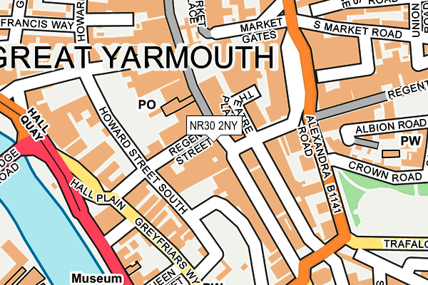
NR30 2NY lies on King Street in Great Yarmouth. NR30 2NY is located in the Nelson electoral ward, within the local authority district of Great Yarmouth and the English Parliamentary constituency of Great Yarmouth. The Sub Integrated Care Board (ICB) Location is NHS Norfolk and Waveney ICB - 26A and the police force is Norfolk. This postcode has been in use since January 1980.


GetTheData
Source: OS OpenMap – Local (Ordnance Survey)
Source: OS VectorMap District (Ordnance Survey)
Licence: Open Government Licence (requires attribution)
| Easting | 652458 |
| Northing | 307530 |
| Latitude | 52.606858 |
| Longitude | 1.727225 |
GetTheData
Source: Open Postcode Geo
Licence: Open Government Licence
| Street | King Street |
| Town/City | Great Yarmouth |
| Country | England |
| Postcode District | NR30 |
| ➜ NR30 open data dashboard ➜ See where NR30 is on a map ➜ Where is Great Yarmouth? | |
GetTheData
Source: Land Registry Price Paid Data
Licence: Open Government Licence
Elevation or altitude of NR30 2NY as distance above sea level:
| Metres | Feet | |
|---|---|---|
| Elevation | 0m | 0ft |
Elevation is measured from the approximate centre of the postcode, to the nearest point on an OS contour line from OS Terrain 50, which has contour spacing of ten vertical metres.
➜ How high above sea level am I? Find the elevation of your current position using your device's GPS.
GetTheData
Source: Open Postcode Elevation
Licence: Open Government Licence
| Ward | Nelson |
| Constituency | Great Yarmouth |
GetTheData
Source: ONS Postcode Database
Licence: Open Government Licence
174, KING STREET, GREAT YARMOUTH, NR30 2NY 1998 7 MAY £460,000 |
GetTheData
Source: HM Land Registry Price Paid Data
Licence: Contains HM Land Registry data © Crown copyright and database right 2024. This data is licensed under the Open Government Licence v3.0.
| January 2024 | Anti-social behaviour | On or near Parking Area | 349m |
| January 2024 | Anti-social behaviour | On or near Cobb'S Place | 364m |
| January 2024 | Violence and sexual offences | On or near Cobb'S Place | 364m |
| ➜ Get more crime data in our Crime section | |||
GetTheData
Source: data.police.uk
Licence: Open Government Licence
| Regents Road (Deneside) | Great Yarmouth | 61m |
| Market Gates | Great Yarmouth | 83m |
| Market Gates | Great Yarmouth | 102m |
| Market Gates | Great Yarmouth | 136m |
| Market Gates | Great Yarmouth | 145m |
| Great Yarmouth Station | 0.7km |
GetTheData
Source: NaPTAN
Licence: Open Government Licence
GetTheData
Source: ONS Postcode Database
Licence: Open Government Licence


➜ Get more ratings from the Food Standards Agency
GetTheData
Source: Food Standards Agency
Licence: FSA terms & conditions
| Last Collection | |||
|---|---|---|---|
| Location | Mon-Fri | Sat | Distance |
| Theatre Plain | 17:30 | 11:30 | 66m |
| Tsb Market Place | 18:30 | 12:00 | 97m |
| Regent Street Post Office | 18:30 | 11:45 | 165m |
GetTheData
Source: Dracos
Licence: Creative Commons Attribution-ShareAlike
| Facility | Distance |
|---|---|
| Legends Fitness Academy Steam Mill Lane, Cobholm, Near Haven Bridge, Great Yarmouth Studio, Health and Fitness Gym | 382m |
| York Road Drill Hall (Closed) York Road, Great Yarmouth Sports Hall | 416m |
| The Gym Group (Great Yarmouth) Pasteur Road, Great Yarmouth Health and Fitness Gym | 631m |
GetTheData
Source: Active Places
Licence: Open Government Licence
| School | Phase of Education | Distance |
|---|---|---|
| St Nicholas Priory CofE VA Primary School St Nicholas Road, Great Yarmouth, NR30 1NL | Primary | 443m |
| St George's Primary School & St. George's Nursery School, Great Yarmouth St Peter's Road, Great Yarmouth, NR30 3BQ | Primary | 666m |
| Novaturient School 22 Euston Road, Great Yarmouth, NR30 1EA | Not applicable | 713m |
GetTheData
Source: Edubase
Licence: Open Government Licence
The below table lists the International Territorial Level (ITL) codes (formerly Nomenclature of Territorial Units for Statistics (NUTS) codes) and Local Administrative Units (LAU) codes for NR30 2NY:
| ITL 1 Code | Name |
|---|---|
| TLH | East |
| ITL 2 Code | Name |
| TLH1 | East Anglia |
| ITL 3 Code | Name |
| TLH15 | Norwich and East Norfolk |
| LAU 1 Code | Name |
| E07000145 | Great Yarmouth |
GetTheData
Source: ONS Postcode Directory
Licence: Open Government Licence
The below table lists the Census Output Area (OA), Lower Layer Super Output Area (LSOA), and Middle Layer Super Output Area (MSOA) for NR30 2NY:
| Code | Name | |
|---|---|---|
| OA | E00135282 | |
| LSOA | E01026623 | Great Yarmouth 006B |
| MSOA | E02005543 | Great Yarmouth 006 |
GetTheData
Source: ONS Postcode Directory
Licence: Open Government Licence
| NR30 1RR | Regent Street | 43m |
| NR30 2BE | Theatre Plain | 51m |
| NR30 1RN | Regent Street | 75m |
| NR30 1LX | Market Place | 94m |
| NR30 2NZ | King Street | 94m |
| NR30 2AB | Regent Road | 100m |
| NR30 1LL | Howard Street South | 104m |
| NR30 1RL | Regent Street | 126m |
| NR30 2QE | Greyfriars Way | 132m |
| NR30 2HL | Deneside | 133m |
GetTheData
Source: Open Postcode Geo; Land Registry Price Paid Data
Licence: Open Government Licence