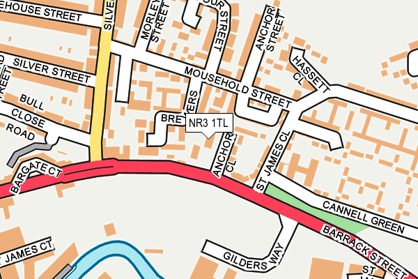
NR3 1TL lies on Barrack Street in Norwich. NR3 1TL is located in the Crome electoral ward, within the local authority district of Norwich and the English Parliamentary constituency of Norwich South. The Sub Integrated Care Board (ICB) Location is NHS Norfolk and Waveney ICB - 26A and the police force is Norfolk. This postcode has been in use since January 1980.


GetTheData
Source: OS OpenMap – Local (Ordnance Survey)
Source: OS VectorMap District (Ordnance Survey)
Licence: Open Government Licence (requires attribution)
| Easting | 623711 |
| Northing | 309450 |
| Latitude | 52.636653 |
| Longitude | 1.304743 |
GetTheData
Source: Open Postcode Geo
Licence: Open Government Licence
| Street | Barrack Street |
| Town/City | Norwich |
| Country | England |
| Postcode District | NR3 |
| ➜ NR3 open data dashboard ➜ See where NR3 is on a map ➜ Where is Norwich? | |
GetTheData
Source: Land Registry Price Paid Data
Licence: Open Government Licence
Elevation or altitude of NR3 1TL as distance above sea level:
| Metres | Feet | |
|---|---|---|
| Elevation | 10m | 33ft |
Elevation is measured from the approximate centre of the postcode, to the nearest point on an OS contour line from OS Terrain 50, which has contour spacing of ten vertical metres.
➜ How high above sea level am I? Find the elevation of your current position using your device's GPS.
GetTheData
Source: Open Postcode Elevation
Licence: Open Government Licence
| Ward | Crome |
| Constituency | Norwich South |
GetTheData
Source: ONS Postcode Database
Licence: Open Government Licence
| January 2024 | Violence and sexual offences | On or near Brewers Court | 83m |
| January 2024 | Public order | On or near Gertrude Road | 499m |
| January 2024 | Violence and sexual offences | On or near Gertrude Road | 499m |
| ➜ Get more crime data in our Crime section | |||
GetTheData
Source: data.police.uk
Licence: Open Government Licence
| Anchor Street (Mousehold Street) | Norwich | 96m |
| Mousehold Street (Silver Road) | Norwich | 167m |
| Mousehold Street (Silver Road) | Norwich | 184m |
| Zaks (Barrack Street) | Norwich | 293m |
| Zaks (Barrack Street) | Norwich | 306m |
| Norwich Station | 1.1km |
GetTheData
Source: NaPTAN
Licence: Open Government Licence
GetTheData
Source: ONS Postcode Database
Licence: Open Government Licence


➜ Get more ratings from the Food Standards Agency
GetTheData
Source: Food Standards Agency
Licence: FSA terms & conditions
| Last Collection | |||
|---|---|---|---|
| Location | Mon-Fri | Sat | Distance |
| St James Close | 18:00 | 11:00 | 112m |
| Bargate Court | 17:30 | 11:00 | 218m |
| Heathgate | 18:00 | 11:00 | 329m |
GetTheData
Source: Dracos
Licence: Creative Commons Attribution-ShareAlike
| Facility | Distance |
|---|---|
| Nuffield Health (Norwich) Barrack Street, Norwich Swimming Pool, Health and Fitness Gym, Studio | 258m |
| Norwich School The Close, Norwich Grass Pitches, Health and Fitness Gym, Sports Hall, Studio | 629m |
| Britannia Barracks Britannia Road, Norwich Grass Pitches | 677m |
GetTheData
Source: Active Places
Licence: Open Government Licence
| School | Phase of Education | Distance |
|---|---|---|
| Mousehold Infant & Nursery School Mousehold Avenue, Norwich, NR3 4RS | Primary | 500m |
| George White Junior School Silver Road, Norwich, NR3 4RG | Primary | 516m |
| Magdalen Gates Primary School and Nursery Bull Close Road, Norwich, NR3 1NG | Primary | 521m |
GetTheData
Source: Edubase
Licence: Open Government Licence
The below table lists the International Territorial Level (ITL) codes (formerly Nomenclature of Territorial Units for Statistics (NUTS) codes) and Local Administrative Units (LAU) codes for NR3 1TL:
| ITL 1 Code | Name |
|---|---|
| TLH | East |
| ITL 2 Code | Name |
| TLH1 | East Anglia |
| ITL 3 Code | Name |
| TLH15 | Norwich and East Norfolk |
| LAU 1 Code | Name |
| E07000148 | Norwich |
GetTheData
Source: ONS Postcode Directory
Licence: Open Government Licence
The below table lists the Census Output Area (OA), Lower Layer Super Output Area (LSOA), and Middle Layer Super Output Area (MSOA) for NR3 1TL:
| Code | Name | |
|---|---|---|
| OA | E00136545 | |
| LSOA | E01026848 | Norwich 015A |
| MSOA | E02006908 | Norwich 015 |
GetTheData
Source: ONS Postcode Directory
Licence: Open Government Licence
| NR3 1TP | Barrack Street | 64m |
| NR3 1UA | Cavalry Ride | 67m |
| NR3 1NT | St James Close | 83m |
| NR3 1LY | Brewers Court | 89m |
| NR3 1NX | Mousehold Street | 93m |
| NR3 1NL | Mousehold Street | 99m |
| NR3 1NP | Mousehold Street | 103m |
| NR3 1NJ | Harcourt Close | 120m |
| NR3 4TX | Silver Road | 153m |
| NR3 1NR | Anchor Street | 154m |
GetTheData
Source: Open Postcode Geo; Land Registry Price Paid Data
Licence: Open Government Licence