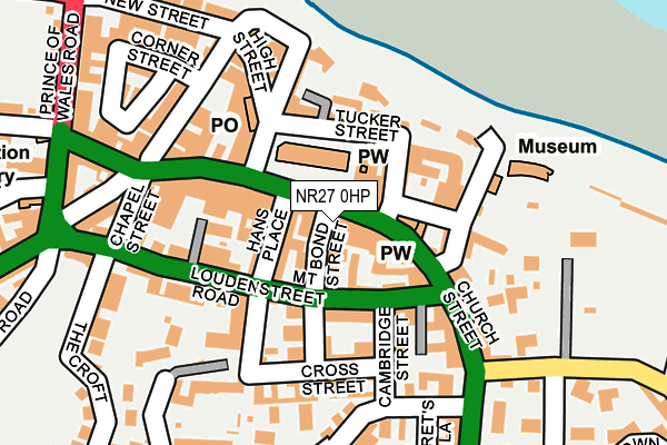
NR27 0HP is located in the Cromer Town electoral ward, within the local authority district of North Norfolk and the English Parliamentary constituency of North Norfolk. The Sub Integrated Care Board (ICB) Location is NHS Norfolk and Waveney ICB - 26A and the police force is Norfolk. This postcode has been in use since December 1997.


GetTheData
Source: OS OpenMap – Local (Ordnance Survey)
Source: OS VectorMap District (Ordnance Survey)
Licence: Open Government Licence (requires attribution)
| Easting | 621985 |
| Northing | 342142 |
| Latitude | 52.930761 |
| Longitude | 1.301434 |
GetTheData
Source: Open Postcode Geo
Licence: Open Government Licence
| Country | England |
| Postcode District | NR27 |
| ➜ NR27 open data dashboard ➜ See where NR27 is on a map ➜ Where is Cromer? | |
GetTheData
Source: Land Registry Price Paid Data
Licence: Open Government Licence
Elevation or altitude of NR27 0HP as distance above sea level:
| Metres | Feet | |
|---|---|---|
| Elevation | 20m | 66ft |
Elevation is measured from the approximate centre of the postcode, to the nearest point on an OS contour line from OS Terrain 50, which has contour spacing of ten vertical metres.
➜ How high above sea level am I? Find the elevation of your current position using your device's GPS.
GetTheData
Source: Open Postcode Elevation
Licence: Open Government Licence
| Ward | Cromer Town |
| Constituency | North Norfolk |
GetTheData
Source: ONS Postcode Database
Licence: Open Government Licence
| January 2024 | Violence and sexual offences | On or near The Gangway | 111m |
| January 2024 | Other theft | On or near Petrol Station | 267m |
| January 2024 | Other theft | On or near Petrol Station | 267m |
| ➜ Get more crime data in our Crime section | |||
GetTheData
Source: data.police.uk
Licence: Open Government Licence
| Church Street | Cromer | 21m |
| Louden Road | Cromer | 157m |
| St Margarets Road (Norwich Road) | Cromer | 230m |
| Cliff Avenue (Overstrand Road) | Cromer | 233m |
| Cliff Avenue (Overstrand Road) | Cromer | 246m |
| Cromer Station | 0.6km |
| Roughton Road Station | 1.4km |
| West Runton Station | 3.8km |
GetTheData
Source: NaPTAN
Licence: Open Government Licence
GetTheData
Source: ONS Postcode Database
Licence: Open Government Licence


➜ Get more ratings from the Food Standards Agency
GetTheData
Source: Food Standards Agency
Licence: FSA terms & conditions
| Last Collection | |||
|---|---|---|---|
| Location | Mon-Fri | Sat | Distance |
| Royal Mail | 18:30 | 12:45 | 8m |
| 15 Tucker Street Post Office | 17:25 | 12:30 | 153m |
| Prince Of Wales Road | 18:15 | 11:45 | 270m |
GetTheData
Source: Dracos
Licence: Creative Commons Attribution-ShareAlike
| Facility | Distance |
|---|---|
| Norton Warnes Ground Overstrand Road, Cromer Grass Pitches | 553m |
| Cromer Lawn Tennis And Squash Norwich Road, Cromer Squash Courts, Outdoor Tennis Courts | 712m |
| Cromer Sports Centre Norwich Road, Cromer Sports Hall, Artificial Grass Pitch | 790m |
GetTheData
Source: Active Places
Licence: Open Government Licence
| School | Phase of Education | Distance |
|---|---|---|
| Cromer Academy Norwich Road, Cromer, NR27 0EX | Secondary | 897m |
| Cromer Junior School Norwich Road, Cromer, NR27 0EX | Primary | 1km |
| Suffield Park Infant and Nursery School, Cromer Mill Road, Cromer, NR27 0AD | Primary | 1km |
GetTheData
Source: Edubase
Licence: Open Government Licence
The below table lists the International Territorial Level (ITL) codes (formerly Nomenclature of Territorial Units for Statistics (NUTS) codes) and Local Administrative Units (LAU) codes for NR27 0HP:
| ITL 1 Code | Name |
|---|---|
| TLH | East |
| ITL 2 Code | Name |
| TLH1 | East Anglia |
| ITL 3 Code | Name |
| TLH16 | North and West Norfolk |
| LAU 1 Code | Name |
| E07000147 | North Norfolk |
GetTheData
Source: ONS Postcode Directory
Licence: Open Government Licence
The below table lists the Census Output Area (OA), Lower Layer Super Output Area (LSOA), and Middle Layer Super Output Area (MSOA) for NR27 0HP:
| Code | Name | |
|---|---|---|
| OA | E00135900 | |
| LSOA | E01026735 | North Norfolk 003B |
| MSOA | E02005572 | North Norfolk 003 |
GetTheData
Source: ONS Postcode Directory
Licence: Open Government Licence
| NR27 9FD | Sea Mews | 42m |
| NR27 9DA | Bond Street | 46m |
| NR27 9ES | Church Street | 50m |
| NR27 9BF | Clarence Mews | 57m |
| NR27 9EY | Brook Street | 59m |
| NR27 9EQ | Hans Place | 62m |
| NR27 9HB | Tucker Street | 72m |
| NR27 9DB | Mount Street | 72m |
| NR27 9EZ | Surrey Street | 73m |
| NR27 9HH | Church Street | 89m |
GetTheData
Source: Open Postcode Geo; Land Registry Price Paid Data
Licence: Open Government Licence