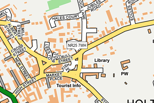
NR25 7WH is located in the Holt electoral ward, within the local authority district of North Norfolk and the English Parliamentary constituency of North Norfolk. The Sub Integrated Care Board (ICB) Location is NHS Norfolk and Waveney ICB - 26A and the police force is Norfolk. This postcode has been in use since June 2004.


GetTheData
Source: OS OpenMap – Local (Ordnance Survey)
Source: OS VectorMap District (Ordnance Survey)
Licence: Open Government Licence (requires attribution)
| Easting | 607937 |
| Northing | 338837 |
| Latitude | 52.906714 |
| Longitude | 1.090644 |
GetTheData
Source: Open Postcode Geo
Licence: Open Government Licence
| Country | England |
| Postcode District | NR25 |
| ➜ NR25 open data dashboard ➜ See where NR25 is on a map ➜ Where is Holt? | |
GetTheData
Source: Land Registry Price Paid Data
Licence: Open Government Licence
Elevation or altitude of NR25 7WH as distance above sea level:
| Metres | Feet | |
|---|---|---|
| Elevation | 60m | 197ft |
Elevation is measured from the approximate centre of the postcode, to the nearest point on an OS contour line from OS Terrain 50, which has contour spacing of ten vertical metres.
➜ How high above sea level am I? Find the elevation of your current position using your device's GPS.
GetTheData
Source: Open Postcode Elevation
Licence: Open Government Licence
| Ward | Holt |
| Constituency | North Norfolk |
GetTheData
Source: ONS Postcode Database
Licence: Open Government Licence
| January 2024 | Criminal damage and arson | On or near Parking Area | 342m |
| November 2023 | Anti-social behaviour | On or near Mill Street | 293m |
| November 2023 | Other theft | On or near Mill Street | 293m |
| ➜ Get more crime data in our Crime section | |||
GetTheData
Source: data.police.uk
Licence: Open Government Licence
| Santander (Market Place) | Holt | 75m |
| Bus Shelter (White Lion Street) | Holt | 90m |
| Railway Tavern (Market Place) | Holt | 108m |
| Kelling Road (Cromer Road) | Holt | 454m |
| Kelling Road (Cromer Road) | Holt | 484m |
| Holt (North Norfolk Railway) | Holt | 1,613m |
GetTheData
Source: NaPTAN
Licence: Open Government Licence
GetTheData
Source: ONS Postcode Database
Licence: Open Government Licence


➜ Get more ratings from the Food Standards Agency
GetTheData
Source: Food Standards Agency
Licence: FSA terms & conditions
| Last Collection | |||
|---|---|---|---|
| Location | Mon-Fri | Sat | Distance |
| Edinburgh Road | 17:15 | 12:15 | 173m |
| Kenwyn Close | 17:00 | 12:15 | 494m |
| The Street | 16:45 | 08:15 | 1,769m |
GetTheData
Source: Dracos
Licence: Creative Commons Attribution-ShareAlike
| Facility | Distance |
|---|---|
| Holt Youth Project Old Station Way, Holt Sports Hall, Health and Fitness Gym | 439m |
| Holt Playing Fields Woodfield Road, Holt Grass Pitches | 662m |
| Gresham's School Cromer Road, Holt Artificial Grass Pitch, Grass Pitches, Sports Hall, Swimming Pool, Outdoor Tennis Courts | 1.1km |
GetTheData
Source: Active Places
Licence: Open Government Licence
| School | Phase of Education | Distance |
|---|---|---|
| Holt Community Primary School Norwich Road, Holt, NR25 6SG | Primary | 443m |
| Gresham's School Cromer Road, Holt, Norfolk, NR25 6EA | Not applicable | 972m |
| Kelling CE Primary School Salthouse Road, Kelling, NR25 7ED | Primary | 4.3km |
GetTheData
Source: Edubase
Licence: Open Government Licence
The below table lists the International Territorial Level (ITL) codes (formerly Nomenclature of Territorial Units for Statistics (NUTS) codes) and Local Administrative Units (LAU) codes for NR25 7WH:
| ITL 1 Code | Name |
|---|---|
| TLH | East |
| ITL 2 Code | Name |
| TLH1 | East Anglia |
| ITL 3 Code | Name |
| TLH16 | North and West Norfolk |
| LAU 1 Code | Name |
| E07000147 | North Norfolk |
GetTheData
Source: ONS Postcode Directory
Licence: Open Government Licence
The below table lists the Census Output Area (OA), Lower Layer Super Output Area (LSOA), and Middle Layer Super Output Area (MSOA) for NR25 7WH:
| Code | Name | |
|---|---|---|
| OA | E00135956 | |
| LSOA | E01026743 | North Norfolk 004C |
| MSOA | E02005573 | North Norfolk 004 |
GetTheData
Source: ONS Postcode Directory
Licence: Open Government Licence
| NR25 6BA | White Lion Street | 41m |
| NR25 6BD | Fish Hill | 61m |
| NR25 6JA | Norman Cockaday Court | 64m |
| NR25 6HP | Bull Street | 67m |
| NR25 6HA | Peacock Lane | 77m |
| NR25 6BB | Church Street | 89m |
| NR25 6HW | Peacock Lane | 95m |
| NR25 6HS | Lees Yard | 106m |
| NR25 6PD | Caston Close | 107m |
| NR25 6EZ | Cromer Road | 119m |
GetTheData
Source: Open Postcode Geo; Land Registry Price Paid Data
Licence: Open Government Licence