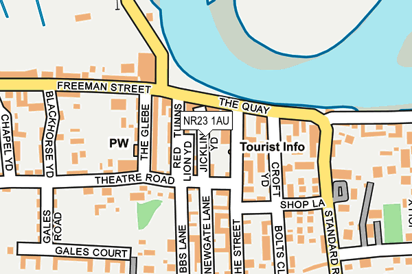
NR23 1AU lies on Jicklings Yard in Wells-next-the-sea. NR23 1AU is located in the Wells with Holkham electoral ward, within the local authority district of North Norfolk and the English Parliamentary constituency of North Norfolk. The Sub Integrated Care Board (ICB) Location is NHS Norfolk and Waveney ICB - 26A and the police force is Norfolk. This postcode has been in use since January 1980.


GetTheData
Source: OS OpenMap – Local (Ordnance Survey)
Source: OS VectorMap District (Ordnance Survey)
Licence: Open Government Licence (requires attribution)
| Easting | 591645 |
| Northing | 343744 |
| Latitude | 52.956848 |
| Longitude | 0.851628 |
GetTheData
Source: Open Postcode Geo
Licence: Open Government Licence
| Street | Jicklings Yard |
| Town/City | Wells-next-the-sea |
| Country | England |
| Postcode District | NR23 |
| ➜ NR23 open data dashboard ➜ See where NR23 is on a map ➜ Where is Wells-next-the-Sea? | |
GetTheData
Source: Land Registry Price Paid Data
Licence: Open Government Licence
Elevation or altitude of NR23 1AU as distance above sea level:
| Metres | Feet | |
|---|---|---|
| Elevation | 10m | 33ft |
Elevation is measured from the approximate centre of the postcode, to the nearest point on an OS contour line from OS Terrain 50, which has contour spacing of ten vertical metres.
➜ How high above sea level am I? Find the elevation of your current position using your device's GPS.
GetTheData
Source: Open Postcode Elevation
Licence: Open Government Licence
| Ward | Wells With Holkham |
| Constituency | North Norfolk |
GetTheData
Source: ONS Postcode Database
Licence: Open Government Licence
| June 2023 | Violence and sexual offences | On or near Parking Area | 44m |
| April 2023 | Violence and sexual offences | On or near Parking Area | 44m |
| June 2022 | Other theft | On or near The Quay | 64m |
| ➜ Get more crime data in our Crime section | |||
GetTheData
Source: data.police.uk
Licence: Open Government Licence
| The Ark Royal (Freeman Street) | Wells-next-the-sea | 103m |
| The Ark Royal (Freeman Street) | Wells-next-the-sea | 136m |
| Northfield Lane (Standard Road) | Wells-next-the-sea | 224m |
| Northfield Lane (Standard Road) | Wells-next-the-sea | 251m |
| The Buttlands | Wells-next-the-sea | 271m |
| Wells-next-the-sea (Wells & Walsingham Railway) | Wells-next-the-sea | 1,178m |
GetTheData
Source: NaPTAN
Licence: Open Government Licence
Estimated total energy consumption in NR23 1AU by fuel type, 2015.
| Consumption (kWh) | 117,983 |
|---|---|
| Meter count | 7 |
| Mean (kWh/meter) | 16,855 |
| Median (kWh/meter) | 10,550 |
GetTheData
Source: Postcode level gas estimates: 2015 (experimental)
Source: Postcode level electricity estimates: 2015 (experimental)
Licence: Open Government Licence
GetTheData
Source: ONS Postcode Database
Licence: Open Government Licence


➜ Get more ratings from the Food Standards Agency
GetTheData
Source: Food Standards Agency
Licence: FSA terms & conditions
| Last Collection | |||
|---|---|---|---|
| Location | Mon-Fri | Sat | Distance |
| The Quay | 16:45 | 10:00 | 56m |
| Staithe Street | 16:30 | 10:00 | 60m |
| Westfield Ave | 16:30 | 10:00 | 281m |
GetTheData
Source: Dracos
Licence: Creative Commons Attribution-ShareAlike
| Facility | Distance |
|---|---|
| Wells Town Tennis Club Gales Road, Wells-next-the-sea Outdoor Tennis Courts | 217m |
| Sea Fit (Closed) Staithe Street, Wells-next-the-sea Health and Fitness Gym | 253m |
| Wells Town Football Club Beach Road, Wells-next-the-sea Grass Pitches | 357m |
GetTheData
Source: Active Places
Licence: Open Government Licence
| School | Phase of Education | Distance |
|---|---|---|
| Wells-Next-the-Sea Primary and Nursery School Polka Road, Wells-Next-the-Sea, NR23 1JG | Primary | 717m |
| Alderman Peel High School Market Lane, Wells-next-the-Sea, NR23 1RB | Secondary | 830m |
GetTheData
Source: Edubase
Licence: Open Government Licence
The below table lists the International Territorial Level (ITL) codes (formerly Nomenclature of Territorial Units for Statistics (NUTS) codes) and Local Administrative Units (LAU) codes for NR23 1AU:
| ITL 1 Code | Name |
|---|---|
| TLH | East |
| ITL 2 Code | Name |
| TLH1 | East Anglia |
| ITL 3 Code | Name |
| TLH16 | North and West Norfolk |
| LAU 1 Code | Name |
| E07000147 | North Norfolk |
GetTheData
Source: ONS Postcode Directory
Licence: Open Government Licence
The below table lists the Census Output Area (OA), Lower Layer Super Output Area (LSOA), and Middle Layer Super Output Area (MSOA) for NR23 1AU:
| Code | Name | |
|---|---|---|
| OA | E00136084 | |
| LSOA | E01026764 | North Norfolk 002C |
| MSOA | E02005571 | North Norfolk 002 |
GetTheData
Source: ONS Postcode Directory
Licence: Open Government Licence
| NR23 1AX | Red Lion Yard | 25m |
| NR23 1AH | The Quay | 45m |
| NR23 1DF | Tunns Yard | 49m |
| NR23 1BP | Hammond Square | 55m |
| NR23 1AQ | Staithe Street | 70m |
| NR23 1FA | The Quay | 86m |
| NR23 1AN | Staithe Street | 87m |
| NR23 1AP | Star Yard | 90m |
| NR23 1AZ | The Glebe | 98m |
| NR23 1DT | Newgate Lane | 112m |
GetTheData
Source: Open Postcode Geo; Land Registry Price Paid Data
Licence: Open Government Licence