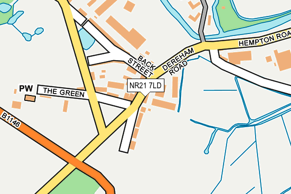
NR21 7LD is located in the The Raynhams electoral ward, within the local authority district of North Norfolk and the English Parliamentary constituency of Broadland. The Sub Integrated Care Board (ICB) Location is NHS Norfolk and Waveney ICB - 26A and the police force is Norfolk. This postcode has been in use since January 1980.


GetTheData
Source: OS OpenMap – Local (Ordnance Survey)
Source: OS VectorMap District (Ordnance Survey)
Licence: Open Government Licence (requires attribution)
| Easting | 591610 |
| Northing | 329157 |
| Latitude | 52.825869 |
| Longitude | 0.842507 |
GetTheData
Source: Open Postcode Geo
Licence: Open Government Licence
| Country | England |
| Postcode District | NR21 |
| ➜ NR21 open data dashboard ➜ See where NR21 is on a map ➜ Where is Hempton? | |
GetTheData
Source: Land Registry Price Paid Data
Licence: Open Government Licence
Elevation or altitude of NR21 7LD as distance above sea level:
| Metres | Feet | |
|---|---|---|
| Elevation | 40m | 131ft |
Elevation is measured from the approximate centre of the postcode, to the nearest point on an OS contour line from OS Terrain 50, which has contour spacing of ten vertical metres.
➜ How high above sea level am I? Find the elevation of your current position using your device's GPS.
GetTheData
Source: Open Postcode Elevation
Licence: Open Government Licence
| Ward | The Raynhams |
| Constituency | Broadland |
GetTheData
Source: ONS Postcode Database
Licence: Open Government Licence
| January 2024 | Public order | On or near Parking Area | 444m |
| January 2024 | Violence and sexual offences | On or near Parking Area | 444m |
| January 2024 | Violence and sexual offences | On or near Parking Area | 444m |
| ➜ Get more crime data in our Crime section | |||
GetTheData
Source: data.police.uk
Licence: Open Government Licence
| Village Sign (Dereham Road) | Hempton | 61m |
| Village Sign (Dereham Road) | Hempton | 73m |
| Green Road (A1065) | Hempton | 428m |
| Green Road (A1065) | Hempton | 438m |
| Bowling Centre (Bridge Street) | Fakenham | 503m |
GetTheData
Source: NaPTAN
Licence: Open Government Licence
GetTheData
Source: ONS Postcode Database
Licence: Open Government Licence


➜ Get more ratings from the Food Standards Agency
GetTheData
Source: Food Standards Agency
Licence: FSA terms & conditions
| Last Collection | |||
|---|---|---|---|
| Location | Mon-Fri | Sat | Distance |
| Mill Road | 16:00 | 10:30 | 486m |
| Bridge Street | 17:15 | 11:15 | 557m |
| Market Place | 17:15 | 11:15 | 574m |
GetTheData
Source: Dracos
Licence: Creative Commons Attribution-ShareAlike
| Facility | Distance |
|---|---|
| Cromwell Barn Health And Fitness Centre Oak Street, Fakenham Health and Fitness Gym, Studio | 635m |
| Fakenham Sports Centre Association The Racecourse, Pudding Norton, Fakenham Indoor Bowls, Golf, Squash Courts, Outdoor Tennis Courts | 786m |
| High Field Lawn Field Lane, Fakenham Grass Pitches | 1.3km |
GetTheData
Source: Active Places
Licence: Open Government Licence
| School | Phase of Education | Distance |
|---|---|---|
| Fakenham Junior School Queen's Road, Fakenham, NR21 8BN | Primary | 842m |
| Fakenham Infant and Nursery School Norwich Road, Fakenham, NR21 8HN | Primary | 1.2km |
| Duke of Lancaster School Highfield Road, Fakenham, NR21 9DQ | Not applicable | 1.2km |
GetTheData
Source: Edubase
Licence: Open Government Licence
The below table lists the International Territorial Level (ITL) codes (formerly Nomenclature of Territorial Units for Statistics (NUTS) codes) and Local Administrative Units (LAU) codes for NR21 7LD:
| ITL 1 Code | Name |
|---|---|
| TLH | East |
| ITL 2 Code | Name |
| TLH1 | East Anglia |
| ITL 3 Code | Name |
| TLH16 | North and West Norfolk |
| LAU 1 Code | Name |
| E07000147 | North Norfolk |
GetTheData
Source: ONS Postcode Directory
Licence: Open Government Licence
The below table lists the Census Output Area (OA), Lower Layer Super Output Area (LSOA), and Middle Layer Super Output Area (MSOA) for NR21 7LD:
| Code | Name | |
|---|---|---|
| OA | E00136170 | |
| LSOA | E01026780 | North Norfolk 009A |
| MSOA | E02005578 | North Norfolk 009 |
GetTheData
Source: ONS Postcode Directory
Licence: Open Government Licence
| NR21 7AB | Dereham Road | 26m |
| NR21 7JY | Dereham Road | 70m |
| NR21 7LG | The Green | 85m |
| NR21 7LE | Back Street | 105m |
| NR21 7LF | Back Street | 167m |
| NR21 7LZ | River Court | 265m |
| NR21 7LA | Hempton Road | 282m |
| NR21 9AY | Bridge Street | 384m |
| NR21 7JZ | Horns Row | 385m |
| NR21 7LH | Mill Road | 442m |
GetTheData
Source: Open Postcode Geo; Land Registry Price Paid Data
Licence: Open Government Licence