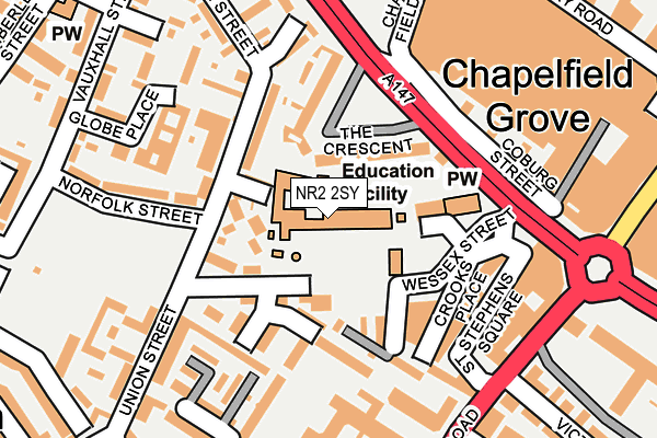
NR2 2SY is located in the Town Close electoral ward, within the local authority district of Norwich and the English Parliamentary constituency of Norwich South. The Sub Integrated Care Board (ICB) Location is NHS Norfolk and Waveney ICB - 26A and the police force is Norfolk. This postcode has been in use since January 2013.


GetTheData
Source: OS OpenMap – Local (Ordnance Survey)
Source: OS VectorMap District (Ordnance Survey)
Licence: Open Government Licence (requires attribution)
| Easting | 622572 |
| Northing | 308060 |
| Latitude | 52.624671 |
| Longitude | 1.287027 |
GetTheData
Source: Open Postcode Geo
Licence: Open Government Licence
| Country | England |
| Postcode District | NR2 |
| ➜ NR2 open data dashboard ➜ See where NR2 is on a map ➜ Where is Norwich? | |
GetTheData
Source: Land Registry Price Paid Data
Licence: Open Government Licence
Elevation or altitude of NR2 2SY as distance above sea level:
| Metres | Feet | |
|---|---|---|
| Elevation | 30m | 98ft |
Elevation is measured from the approximate centre of the postcode, to the nearest point on an OS contour line from OS Terrain 50, which has contour spacing of ten vertical metres.
➜ How high above sea level am I? Find the elevation of your current position using your device's GPS.
GetTheData
Source: Open Postcode Elevation
Licence: Open Government Licence
| Ward | Town Close |
| Constituency | Norwich South |
GetTheData
Source: ONS Postcode Database
Licence: Open Government Licence
| January 2024 | Violence and sexual offences | On or near Woburn Street | 420m |
| January 2024 | Anti-social behaviour | On or near Parking Area | 440m |
| January 2024 | Anti-social behaviour | On or near Parking Area | 440m |
| ➜ Get more crime data in our Crime section | |||
GetTheData
Source: data.police.uk
Licence: Open Government Licence
| Chapelfield Mall (Chapel Field Road) | Norwich | 119m |
| St Stephens Square (St Stephens Road) | Norwich | 215m |
| St Stephens Square (St Stephens Road) | Norwich | 221m |
| St Stephens Street | Norwich City Centre | 289m |
| St Stephens Street | Norwich City Centre | 289m |
| Norwich Station | 1.4km |
GetTheData
Source: NaPTAN
Licence: Open Government Licence
GetTheData
Source: ONS Postcode Database
Licence: Open Government Licence


➜ Get more ratings from the Food Standards Agency
GetTheData
Source: Food Standards Agency
Licence: FSA terms & conditions
| Last Collection | |||
|---|---|---|---|
| Location | Mon-Fri | Sat | Distance |
| Union Street | 17:30 | 11:00 | 126m |
| St Stephens Road | 18:45 | 11:00 | 241m |
| Vauxhall Street Post Office | 17:30 | 12:00 | 274m |
GetTheData
Source: Dracos
Licence: Creative Commons Attribution-ShareAlike
| Facility | Distance |
|---|---|
| Bignold Primary School Wessex Street, Wessex Street, Norwich Grass Pitches | 0m |
| Norwich Church Of Englands Young Mens Society Squash Club (Closed) Haymarket, Norwich Health and Fitness Gym, Squash Courts | 476m |
| Ymca (Norwich) (Closed) St. Giles Street, Norwich Sports Hall | 508m |
GetTheData
Source: Active Places
Licence: Open Government Licence
| School | Phase of Education | Distance |
|---|---|---|
| Bignold Primary School and Nursery Wessex Street, Norwich, NR2 2SY | Primary | 1m |
| Sir Isaac Newton Sixth Form Free School The Old Fire Station, 30 Bethel Street, Norwich, NR2 1NR | 16 plus | 461m |
| The Free School Norwich Kings House, 15-17 Surrey Street, Norwich, NR1 3NX | Primary | 495m |
GetTheData
Source: Edubase
Licence: Open Government Licence
The below table lists the International Territorial Level (ITL) codes (formerly Nomenclature of Territorial Units for Statistics (NUTS) codes) and Local Administrative Units (LAU) codes for NR2 2SY:
| ITL 1 Code | Name |
|---|---|
| TLH | East |
| ITL 2 Code | Name |
| TLH1 | East Anglia |
| ITL 3 Code | Name |
| TLH15 | Norwich and East Norfolk |
| LAU 1 Code | Name |
| E07000148 | Norwich |
GetTheData
Source: ONS Postcode Directory
Licence: Open Government Licence
The below table lists the Census Output Area (OA), Lower Layer Super Output Area (LSOA), and Middle Layer Super Output Area (MSOA) for NR2 2SY:
| Code | Name | |
|---|---|---|
| OA | E00136598 | |
| LSOA | E01033437 | Norwich 011H |
| MSOA | E02005594 | Norwich 011 |
GetTheData
Source: ONS Postcode Directory
Licence: Open Government Licence
| NR2 1SA | The Crescent | 58m |
| NR2 2TJ | Wessex Street | 76m |
| NR2 2SL | Union Street | 90m |
| NR2 2SP | Wessex Street | 101m |
| NR2 2TH | Kenneth Mckee Plain | 133m |
| NR1 3UF | Crooks Place | 145m |
| NR1 3SS | St Stephens Square | 151m |
| NR2 2TA | Phillipa Flowerday Plain | 153m |
| NR2 1RZ | Coach & Horses Row | 164m |
| NR2 2SN | Norfolk Street | 173m |
GetTheData
Source: Open Postcode Geo; Land Registry Price Paid Data
Licence: Open Government Licence