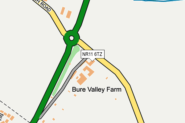
NR11 6TZ lies on Burgh Road in Aylsham, Norwich. NR11 6TZ is located in the Aylsham electoral ward, within the local authority district of Broadland and the English Parliamentary constituency of Broadland. The Sub Integrated Care Board (ICB) Location is NHS Norfolk and Waveney ICB - 26A and the police force is Norfolk. This postcode has been in use since January 1980.


GetTheData
Source: OS OpenMap – Local (Ordnance Survey)
Source: OS VectorMap District (Ordnance Survey)
Licence: Open Government Licence (requires attribution)
| Easting | 620394 |
| Northing | 326397 |
| Latitude | 52.790136 |
| Longitude | 1.267184 |
GetTheData
Source: Open Postcode Geo
Licence: Open Government Licence
| Street | Burgh Road |
| Locality | Aylsham |
| Town/City | Norwich |
| Country | England |
| Postcode District | NR11 |
| ➜ NR11 open data dashboard ➜ See where NR11 is on a map | |
GetTheData
Source: Land Registry Price Paid Data
Licence: Open Government Licence
Elevation or altitude of NR11 6TZ as distance above sea level:
| Metres | Feet | |
|---|---|---|
| Elevation | 20m | 66ft |
Elevation is measured from the approximate centre of the postcode, to the nearest point on an OS contour line from OS Terrain 50, which has contour spacing of ten vertical metres.
➜ How high above sea level am I? Find the elevation of your current position using your device's GPS.
GetTheData
Source: Open Postcode Elevation
Licence: Open Government Licence
| Ward | Aylsham |
| Constituency | Broadland |
GetTheData
Source: ONS Postcode Database
Licence: Open Government Licence
| June 2022 | Shoplifting | On or near Bure Valley Lane | 197m |
| June 2022 | Shoplifting | On or near Bure Valley Lane | 197m |
| April 2022 | Criminal damage and arson | On or near Bure Valley Lane | 197m |
| ➜ Burgh Road crime map and outcomes | |||
GetTheData
Source: data.police.uk
Licence: Open Government Licence
| High School (Sir William's Lane) | Aylsham | 860m |
| Tesco (Norwich Road) | Aylsham | 891m |
| Tesco (Norwich Road) | Aylsham | 912m |
| Motel (Norwich Road) | Aylsham | 918m |
| Motel (Norwich Road) | Aylsham | 936m |
| Aylsham (Bure Valley Railway) | Aylsham | 840m |
GetTheData
Source: NaPTAN
Licence: Open Government Licence
| Percentage of properties with Next Generation Access | 100.0% |
| Percentage of properties with Superfast Broadband | 100.0% |
| Percentage of properties with Ultrafast Broadband | 0.0% |
| Percentage of properties with Full Fibre Broadband | 0.0% |
Superfast Broadband is between 30Mbps and 300Mbps
Ultrafast Broadband is > 300Mbps
| Percentage of properties unable to receive 2Mbps | 0.0% |
| Percentage of properties unable to receive 5Mbps | 0.0% |
| Percentage of properties unable to receive 10Mbps | 0.0% |
| Percentage of properties unable to receive 30Mbps | 0.0% |
GetTheData
Source: Ofcom
Licence: Ofcom Terms of Use (requires attribution)
GetTheData
Source: ONS Postcode Database
Licence: Open Government Licence


➜ Get more ratings from the Food Standards Agency
GetTheData
Source: Food Standards Agency
Licence: FSA terms & conditions
| Last Collection | |||
|---|---|---|---|
| Location | Mon-Fri | Sat | Distance |
| Tesco Stores | 17:00 | 07:00 | 951m |
| Upper Hungate Street | 17:15 | 08:50 | 1,134m |
| Dunkirk | 16:00 | 08:30 | 1,249m |
GetTheData
Source: Dracos
Licence: Creative Commons Attribution-ShareAlike
| Facility | Distance |
|---|---|
| Aylsham Recreation Ground Sir Williams Lane, Aylsham, Norwich Grass Pitches, Outdoor Tennis Courts | 698m |
| Aylsham High School Sir Williams Lane, Aylsham, Norwich Swimming Pool, Sports Hall, Grass Pitches, Artificial Grass Pitch, Studio | 886m |
| Bure Valley Junior School Hungate Street, Aylsham, Norwich Grass Pitches, Sports Hall | 1.1km |
GetTheData
Source: Active Places
Licence: Open Government Licence
| School | Phase of Education | Distance |
|---|---|---|
| Aylsham High School Sir Williams Lane, Aylsham, Norwich, NR11 6AN | Secondary | 886m |
| John of Gaunt Infant and Nursery School Hungate Street, Aylsham, Norwich, NR11 6JZ | Primary | 1.1km |
| Bure Valley School Hungate Street, Aylsham, Norwich, NR11 6JZ | Primary | 1.1km |
GetTheData
Source: Edubase
Licence: Open Government Licence
The below table lists the International Territorial Level (ITL) codes (formerly Nomenclature of Territorial Units for Statistics (NUTS) codes) and Local Administrative Units (LAU) codes for NR11 6TZ:
| ITL 1 Code | Name |
|---|---|
| TLH | East |
| ITL 2 Code | Name |
| TLH1 | East Anglia |
| ITL 3 Code | Name |
| TLH15 | Norwich and East Norfolk |
| LAU 1 Code | Name |
| E07000144 | Broadland |
GetTheData
Source: ONS Postcode Directory
Licence: Open Government Licence
The below table lists the Census Output Area (OA), Lower Layer Super Output Area (LSOA), and Middle Layer Super Output Area (MSOA) for NR11 6TZ:
| Code | Name | |
|---|---|---|
| OA | E00134662 | |
| LSOA | E01026501 | Broadland 001C |
| MSOA | E02005520 | Broadland 001 |
GetTheData
Source: ONS Postcode Directory
Licence: Open Government Licence
| NR11 6UA | Bure Valley Lane | 334m |
| NR11 6LD | Lancaster Gardens | 384m |
| NR11 6LB | Lancaster Gardens | 403m |
| NR11 6UB | Buxton Road | 448m |
| NR11 6FP | Dove Gardens | 489m |
| NR11 6GB | Buckenham Road | 523m |
| NR11 6JF | Soame Close | 526m |
| NR11 6BH | Rippingall Road | 562m |
| NR11 6FN | Palmerston Way | 570m |
| NR11 6AS | Burgh Road | 582m |
GetTheData
Source: Open Postcode Geo; Land Registry Price Paid Data
Licence: Open Government Licence