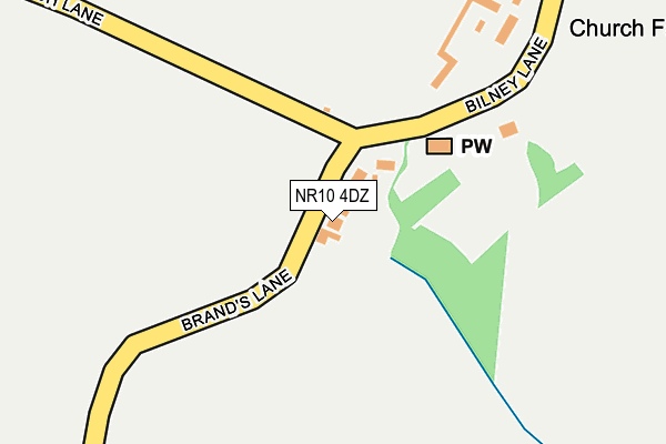
NR10 4DZ lies on Brands Lane in Felthorpe, Norwich. NR10 4DZ is located in the Horsford and Felthorpe electoral ward, within the local authority district of Broadland and the English Parliamentary constituency of Broadland. The Sub Integrated Care Board (ICB) Location is NHS Norfolk and Waveney ICB - 26A and the police force is Norfolk. This postcode has been in use since January 1980.


GetTheData
Source: OS OpenMap – Local (Ordnance Survey)
Source: OS VectorMap District (Ordnance Survey)
Licence: Open Government Licence (requires attribution)
| Easting | 616885 |
| Northing | 317250 |
| Latitude | 52.709431 |
| Longitude | 1.209168 |
GetTheData
Source: Open Postcode Geo
Licence: Open Government Licence
| Street | Brands Lane |
| Locality | Felthorpe |
| Town/City | Norwich |
| Country | England |
| Postcode District | NR10 |
| ➜ NR10 open data dashboard ➜ See where NR10 is on a map | |
GetTheData
Source: Land Registry Price Paid Data
Licence: Open Government Licence
Elevation or altitude of NR10 4DZ as distance above sea level:
| Metres | Feet | |
|---|---|---|
| Elevation | 30m | 98ft |
Elevation is measured from the approximate centre of the postcode, to the nearest point on an OS contour line from OS Terrain 50, which has contour spacing of ten vertical metres.
➜ How high above sea level am I? Find the elevation of your current position using your device's GPS.
GetTheData
Source: Open Postcode Elevation
Licence: Open Government Licence
| Ward | Horsford And Felthorpe |
| Constituency | Broadland |
GetTheData
Source: ONS Postcode Database
Licence: Open Government Licence
| April 2022 | Violence and sexual offences | On or near Church Lane | 328m |
| November 2021 | Violence and sexual offences | On or near Church Lane | 328m |
| November 2021 | Violence and sexual offences | On or near Church Lane | 328m |
| ➜ Get more crime data in our Crime section | |||
GetTheData
Source: data.police.uk
Licence: Open Government Licence
| Nash Road (The Street) | Felthorpe | 701m |
| Nash Road (The Street) | Felthorpe | 705m |
| The Mariners (The Street) | Felthorpe | 742m |
| The Mariners (The Street) | Felthorpe | 760m |
| Bilney Lane (Short Thorn Road) | Felthorpe | 1,198m |
GetTheData
Source: NaPTAN
Licence: Open Government Licence
| Percentage of properties with Next Generation Access | 100.0% |
| Percentage of properties with Superfast Broadband | 0.0% |
| Percentage of properties with Ultrafast Broadband | 0.0% |
| Percentage of properties with Full Fibre Broadband | 0.0% |
Superfast Broadband is between 30Mbps and 300Mbps
Ultrafast Broadband is > 300Mbps
| Percentage of properties unable to receive 2Mbps | 0.0% |
| Percentage of properties unable to receive 5Mbps | 0.0% |
| Percentage of properties unable to receive 10Mbps | 0.0% |
| Percentage of properties unable to receive 30Mbps | 100.0% |
GetTheData
Source: Ofcom
Licence: Ofcom Terms of Use (requires attribution)
GetTheData
Source: ONS Postcode Database
Licence: Open Government Licence


➜ Get more ratings from the Food Standards Agency
GetTheData
Source: Food Standards Agency
Licence: FSA terms & conditions
| Last Collection | |||
|---|---|---|---|
| Location | Mon-Fri | Sat | Distance |
| The Street Former P.o. | 16:00 | 09:15 | 771m |
| Mill Lane | 16:00 | 10:00 | 2,203m |
| Pendlesham Rise / Castle Rise | 16:00 | 10:00 | 2,346m |
GetTheData
Source: Dracos
Licence: Creative Commons Attribution-ShareAlike
| Facility | Distance |
|---|---|
| Felthorpe Recreation Ground The Street, Felthorpe, Norwich Grass Pitches, Sports Hall | 826m |
| Watling Park Hall Lane, Felthorpe, Norwich Grass Pitches | 1.3km |
| Horsford Ce Primary School Mill Lane, Horsford, Norwich Grass Pitches, Sports Hall | 2.3km |
GetTheData
Source: Active Places
Licence: Open Government Licence
| School | Phase of Education | Distance |
|---|---|---|
| Horsford CofE VA Primary School Mill Lane, Horsford, Norwich, NR10 3ES | Primary | 2.3km |
| Drayton Community Infant School School Road, Drayton, Norwich, NR8 6EP | Primary | 2.9km |
| Taverham High School Beech Avenue, Taverham, Norwich, NR8 6HP | Secondary | 3km |
GetTheData
Source: Edubase
Licence: Open Government Licence
The below table lists the International Territorial Level (ITL) codes (formerly Nomenclature of Territorial Units for Statistics (NUTS) codes) and Local Administrative Units (LAU) codes for NR10 4DZ:
| ITL 1 Code | Name |
|---|---|
| TLH | East |
| ITL 2 Code | Name |
| TLH1 | East Anglia |
| ITL 3 Code | Name |
| TLH15 | Norwich and East Norfolk |
| LAU 1 Code | Name |
| E07000144 | Broadland |
GetTheData
Source: ONS Postcode Directory
Licence: Open Government Licence
The below table lists the Census Output Area (OA), Lower Layer Super Output Area (LSOA), and Middle Layer Super Output Area (MSOA) for NR10 4DZ:
| Code | Name | |
|---|---|---|
| OA | E00134836 | |
| LSOA | E01026535 | Broadland 004C |
| MSOA | E02005523 | Broadland 004 |
GetTheData
Source: ONS Postcode Directory
Licence: Open Government Licence
| NR10 4EB | Bilney Lane | 190m |
| NR10 4DP | Church Lane | 554m |
| NR10 4DS | Taverham Road | 650m |
| NR10 4DG | The Street | 663m |
| NR10 4DR | Taverham Road | 681m |
| NR10 4EE | School Court | 709m |
| NR10 4BU | The Street | 711m |
| NR10 4FL | Abels Close | 750m |
| NR10 4DJ | Nash Road | 760m |
| NR10 4EA | Brands Lane | 768m |
GetTheData
Source: Open Postcode Geo; Land Registry Price Paid Data
Licence: Open Government Licence