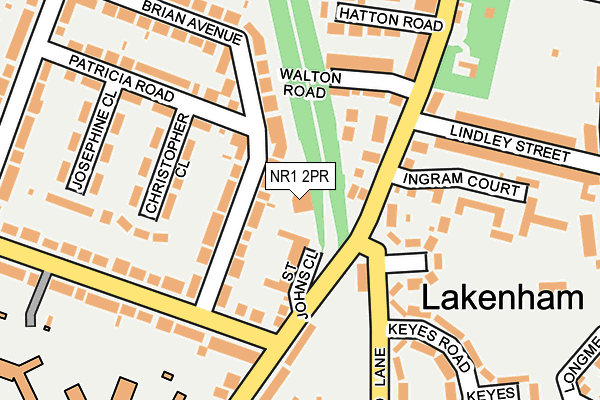
NR1 2PR is located in the Town Close electoral ward, within the local authority district of Norwich and the English Parliamentary constituency of Norwich South. The Sub Integrated Care Board (ICB) Location is NHS Norfolk and Waveney ICB - 26A and the police force is Norfolk. This postcode has been in use since January 1980.


GetTheData
Source: OS OpenMap – Local (Ordnance Survey)
Source: OS VectorMap District (Ordnance Survey)
Licence: Open Government Licence (requires attribution)
| Easting | 623132 |
| Northing | 307016 |
| Latitude | 52.615047 |
| Longitude | 1.294559 |
GetTheData
Source: Open Postcode Geo
Licence: Open Government Licence
| Country | England |
| Postcode District | NR1 |
| ➜ NR1 open data dashboard ➜ See where NR1 is on a map ➜ Where is Norwich? | |
GetTheData
Source: Land Registry Price Paid Data
Licence: Open Government Licence
Elevation or altitude of NR1 2PR as distance above sea level:
| Metres | Feet | |
|---|---|---|
| Elevation | 30m | 98ft |
Elevation is measured from the approximate centre of the postcode, to the nearest point on an OS contour line from OS Terrain 50, which has contour spacing of ten vertical metres.
➜ How high above sea level am I? Find the elevation of your current position using your device's GPS.
GetTheData
Source: Open Postcode Elevation
Licence: Open Government Licence
| Ward | Town Close |
| Constituency | Norwich South |
GetTheData
Source: ONS Postcode Database
Licence: Open Government Licence
| January 2023 | Violence and sexual offences | On or near Trafford Road | 352m |
| January 2023 | Violence and sexual offences | On or near Trafford Road | 352m |
| June 2022 | Public order | On or near St Johns Close | 80m |
| ➜ Get more crime data in our Crime section | |||
GetTheData
Source: data.police.uk
Licence: Open Government Licence
| Keyes Road (Mansfield Lane) | Norwich | 125m |
| Keyes Road (Mansfield Lane) | Norwich | 157m |
| Hewett School (Cecil Road) | Norwich | 163m |
| Hewett School (Cecil Road) | Norwich | 196m |
| Latimer Road (Hall Road) | Norwich | 241m |
| Norwich Station | 1.6km |
GetTheData
Source: NaPTAN
Licence: Open Government Licence
GetTheData
Source: ONS Postcode Database
Licence: Open Government Licence


➜ Get more ratings from the Food Standards Agency
GetTheData
Source: Food Standards Agency
Licence: FSA terms & conditions
| Last Collection | |||
|---|---|---|---|
| Location | Mon-Fri | Sat | Distance |
| St Johns Close Post Office | 18:30 | 11:00 | 101m |
| Hospital Lane | 17:45 | 11:00 | 281m |
| Stratford Drive | 17:45 | 11:00 | 324m |
GetTheData
Source: Dracos
Licence: Creative Commons Attribution-ShareAlike
| Facility | Distance |
|---|---|
| Lakenham Recreation Ground City Road, Norwich Outdoor Tennis Courts | 296m |
| The Hewett Academy Cecil Road, Norwich Athletics, Sports Hall, Swimming Pool, Grass Pitches, Outdoor Tennis Courts | 362m |
| Lakenham Primary School City Road, Norwich Grass Pitches | 389m |
GetTheData
Source: Active Places
Licence: Open Government Licence
| School | Phase of Education | Distance |
|---|---|---|
| Norwich Steiner School Hospital Lane, Norwich, NR1 2HW | Not applicable | 366m |
| Lakenham Primary School City Road, Norwich, NR1 2HL | Primary | 371m |
| Hewett Academy Cecil Road, Norwich, NR1 2PL | Secondary | 423m |
GetTheData
Source: Edubase
Licence: Open Government Licence
The below table lists the International Territorial Level (ITL) codes (formerly Nomenclature of Territorial Units for Statistics (NUTS) codes) and Local Administrative Units (LAU) codes for NR1 2PR:
| ITL 1 Code | Name |
|---|---|
| TLH | East |
| ITL 2 Code | Name |
| TLH1 | East Anglia |
| ITL 3 Code | Name |
| TLH15 | Norwich and East Norfolk |
| LAU 1 Code | Name |
| E07000148 | Norwich |
GetTheData
Source: ONS Postcode Directory
Licence: Open Government Licence
The below table lists the Census Output Area (OA), Lower Layer Super Output Area (LSOA), and Middle Layer Super Output Area (MSOA) for NR1 2PR:
| Code | Name | |
|---|---|---|
| OA | E00136593 | |
| LSOA | E01026852 | Norwich 011A |
| MSOA | E02005594 | Norwich 011 |
GetTheData
Source: ONS Postcode Directory
Licence: Open Government Licence
| NR1 2AD | St Johns Close | 72m |
| NR1 2PH | Brian Avenue | 78m |
| NR1 2PQ | Christopher Close | 131m |
| NR1 2PP | Hall Road | 140m |
| NR1 2PS | Walton Road | 145m |
| NR1 2JU | Mendham Close | 153m |
| NR1 2PN | Cecil Road | 162m |
| NR1 2PY | Ingram Court | 164m |
| NR1 2JT | Mansfield Lane | 175m |
| NR1 2PE | Patricia Road | 183m |
GetTheData
Source: Open Postcode Geo; Land Registry Price Paid Data
Licence: Open Government Licence