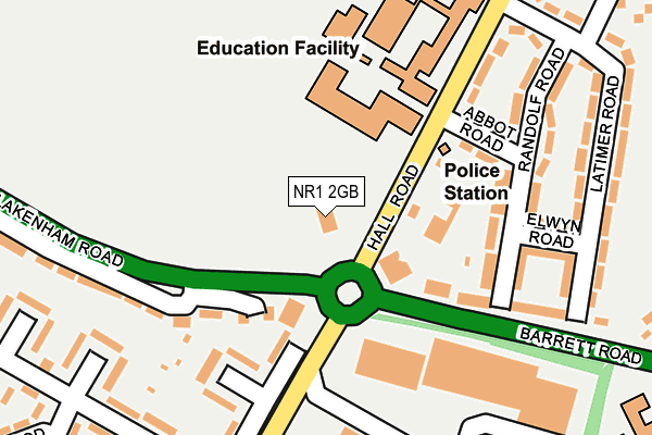
NR1 2GB is located in the Lakenham electoral ward, within the local authority district of Norwich and the English Parliamentary constituency of Norwich South. The Sub Integrated Care Board (ICB) Location is NHS Norfolk and Waveney ICB - 26A and the police force is Norfolk. This postcode has been in use since November 2010.


GetTheData
Source: OS OpenMap – Local (Ordnance Survey)
Source: OS VectorMap District (Ordnance Survey)
Licence: Open Government Licence (requires attribution)
| Easting | 622884 |
| Northing | 306645 |
| Latitude | 52.611843 |
| Longitude | 1.290676 |
GetTheData
Source: Open Postcode Geo
Licence: Open Government Licence
| Country | England |
| Postcode District | NR1 |
| ➜ NR1 open data dashboard ➜ See where NR1 is on a map ➜ Where is Norwich? | |
GetTheData
Source: Land Registry Price Paid Data
Licence: Open Government Licence
Elevation or altitude of NR1 2GB as distance above sea level:
| Metres | Feet | |
|---|---|---|
| Elevation | 30m | 98ft |
Elevation is measured from the approximate centre of the postcode, to the nearest point on an OS contour line from OS Terrain 50, which has contour spacing of ten vertical metres.
➜ How high above sea level am I? Find the elevation of your current position using your device's GPS.
GetTheData
Source: Open Postcode Elevation
Licence: Open Government Licence
| Ward | Lakenham |
| Constituency | Norwich South |
GetTheData
Source: ONS Postcode Database
Licence: Open Government Licence
| January 2024 | Violence and sexual offences | On or near Hall Road | 277m |
| January 2024 | Violence and sexual offences | On or near Hall Road | 277m |
| January 2024 | Violence and sexual offences | On or near Hall Road | 277m |
| ➜ Get more crime data in our Crime section | |||
GetTheData
Source: data.police.uk
Licence: Open Government Licence
| Abbot Road (Hall Road) | Norwich | 105m |
| Abbot Road (Hall Road) | Norwich | 114m |
| Latimer Road (Hall Road) | Norwich | 175m |
| Latimer Road (Hall Road) | Norwich | 223m |
| Hall Road (Barrett Road) | Norwich | 226m |
| Norwich Station | 2km |
GetTheData
Source: NaPTAN
Licence: Open Government Licence
GetTheData
Source: ONS Postcode Database
Licence: Open Government Licence


➜ Get more ratings from the Food Standards Agency
GetTheData
Source: Food Standards Agency
Licence: FSA terms & conditions
| Last Collection | |||
|---|---|---|---|
| Location | Mon-Fri | Sat | Distance |
| Hall Road | 17:30 | 11:00 | 229m |
| Beeching Road | 17:45 | 11:00 | 321m |
| St Johns Close Post Office | 18:30 | 11:00 | 369m |
GetTheData
Source: Dracos
Licence: Creative Commons Attribution-ShareAlike
| Facility | Distance |
|---|---|
| Goals (Norwich) Hall Road, Norwich Artificial Grass Pitch | 110m |
| The Hewett Academy Cecil Road, Norwich Athletics, Sports Hall, Swimming Pool, Grass Pitches, Outdoor Tennis Courts | 229m |
| Tch Dragons Den Hall Road, Norwich Artificial Grass Pitch | 240m |
GetTheData
Source: Active Places
Licence: Open Government Licence
| School | Phase of Education | Distance |
|---|---|---|
| The Wherry School 280 Hall Road, Norwich, NR1 2GB | Not applicable | 0m |
| Hewett Academy Cecil Road, Norwich, NR1 2PL | Secondary | 264m |
| Edith Cavell Academy and Nursery Duckett Close, Norwich, NR1 2LR | Primary | 422m |
GetTheData
Source: Edubase
Licence: Open Government Licence
The below table lists the International Territorial Level (ITL) codes (formerly Nomenclature of Territorial Units for Statistics (NUTS) codes) and Local Administrative Units (LAU) codes for NR1 2GB:
| ITL 1 Code | Name |
|---|---|
| TLH | East |
| ITL 2 Code | Name |
| TLH1 | East Anglia |
| ITL 3 Code | Name |
| TLH15 | Norwich and East Norfolk |
| LAU 1 Code | Name |
| E07000148 | Norwich |
GetTheData
Source: ONS Postcode Directory
Licence: Open Government Licence
The below table lists the Census Output Area (OA), Lower Layer Super Output Area (LSOA), and Middle Layer Super Output Area (MSOA) for NR1 2GB:
| Code | Name | |
|---|---|---|
| OA | E00136382 | |
| LSOA | E01026818 | Norwich 013C |
| MSOA | E02005596 | Norwich 013 |
GetTheData
Source: ONS Postcode Directory
Licence: Open Government Licence
| NR1 2RN | Hall Road | 131m |
| NR1 2RZ | Abbot Road | 137m |
| NR1 2RY | Randolf Road | 189m |
| NR1 2RU | Randolf Road | 197m |
| NR1 2RW | Latimer Road | 208m |
| NR1 2RX | Elwyn Road | 225m |
| NR1 2RT | Barrett Road | 247m |
| NR1 2RR | Latimer Road | 256m |
| NR4 6NE | Hall Road | 257m |
| NR4 6BB | Lakenham Road | 276m |
GetTheData
Source: Open Postcode Geo; Land Registry Price Paid Data
Licence: Open Government Licence