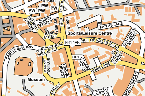
NR1 1AR is located in the Thorpe Hamlet electoral ward, within the local authority district of Norwich and the English Parliamentary constituency of Norwich South. The Sub Integrated Care Board (ICB) Location is NHS Norfolk and Waveney ICB - 26A and the police force is Norfolk. This postcode has been in use since December 1995.


GetTheData
Source: OS OpenMap – Local (Ordnance Survey)
Source: OS VectorMap District (Ordnance Survey)
Licence: Open Government Licence (requires attribution)
| Easting | 623387 |
| Northing | 308603 |
| Latitude | 52.629185 |
| Longitude | 1.299391 |
GetTheData
Source: Open Postcode Geo
Licence: Open Government Licence
| Country | England |
| Postcode District | NR1 |
| ➜ NR1 open data dashboard ➜ See where NR1 is on a map ➜ Where is Norwich? | |
GetTheData
Source: Land Registry Price Paid Data
Licence: Open Government Licence
Elevation or altitude of NR1 1AR as distance above sea level:
| Metres | Feet | |
|---|---|---|
| Elevation | 10m | 33ft |
Elevation is measured from the approximate centre of the postcode, to the nearest point on an OS contour line from OS Terrain 50, which has contour spacing of ten vertical metres.
➜ How high above sea level am I? Find the elevation of your current position using your device's GPS.
GetTheData
Source: Open Postcode Elevation
Licence: Open Government Licence
| Ward | Thorpe Hamlet |
| Constituency | Norwich South |
GetTheData
Source: ONS Postcode Database
Licence: Open Government Licence
| January 2024 | Vehicle crime | On or near Mountergate | 293m |
| January 2024 | Anti-social behaviour | On or near Parking Area | 434m |
| January 2024 | Criminal damage and arson | On or near Friars Quay | 458m |
| ➜ Get more crime data in our Crime section | |||
GetTheData
Source: data.police.uk
Licence: Open Government Licence
| Prince Of Wales Road | Norwich | 96m |
| Upper King Street | Norwich | 116m |
| Bank Street (Bank Plain) | Norwich | 135m |
| Bank Street (Bank Plain) | Norwich | 147m |
| Castle Meadow | Norwich City Centre | 159m |
| Norwich Station | 0.6km |
GetTheData
Source: NaPTAN
Licence: Open Government Licence
GetTheData
Source: ONS Postcode Database
Licence: Open Government Licence


➜ Get more ratings from the Food Standards Agency
GetTheData
Source: Food Standards Agency
Licence: FSA terms & conditions
| Last Collection | |||
|---|---|---|---|
| Location | Mon-Fri | Sat | Distance |
| Bank Plain | 19:00 | 11:00 | 138m |
| Bank Plain Business Box | 19:00 | 11:00 | 141m |
| Opie Street | 18:45 | 11:00 | 212m |
GetTheData
Source: Dracos
Licence: Creative Commons Attribution-ShareAlike
| Facility | Distance |
|---|---|
| Norwich School The Close, Norwich Grass Pitches, Health and Fitness Gym, Sports Hall, Studio | 304m |
| The Gym Group (Norwich City) Little London Street, Norwich Health and Fitness Gym | 337m |
| Puregym (Norwich Castle Mall) Castle Mall, Norwich Health and Fitness Gym | 385m |
GetTheData
Source: Active Places
Licence: Open Government Licence
| School | Phase of Education | Distance |
|---|---|---|
| Norwich School 71A The Close, Norwich, NR1 4DD | Not applicable | 183m |
| Norwich University of the Arts Francis House, 3 - 7 Redwell Street, Norwich, NR2 4SN | Not applicable | 247m |
| Charles Darwin Primary School 81 Rose Lane, Norwich, NR1 1DJ | Primary | 312m |
GetTheData
Source: Edubase
Licence: Open Government Licence
The below table lists the International Territorial Level (ITL) codes (formerly Nomenclature of Territorial Units for Statistics (NUTS) codes) and Local Administrative Units (LAU) codes for NR1 1AR:
| ITL 1 Code | Name |
|---|---|
| TLH | East |
| ITL 2 Code | Name |
| TLH1 | East Anglia |
| ITL 3 Code | Name |
| TLH15 | Norwich and East Norfolk |
| LAU 1 Code | Name |
| E07000148 | Norwich |
GetTheData
Source: ONS Postcode Directory
Licence: Open Government Licence
The below table lists the Census Output Area (OA), Lower Layer Super Output Area (LSOA), and Middle Layer Super Output Area (MSOA) for NR1 1AR:
| Code | Name | |
|---|---|---|
| OA | E00173856 | |
| LSOA | E01033440 | Norwich 014C |
| MSOA | E02006907 | Norwich 014 |
GetTheData
Source: ONS Postcode Directory
Licence: Open Government Licence
| NR1 1DB | King Street | 45m |
| NR1 1LB | Prince Of Wales Road | 48m |
| NR1 1PR | Greyfriars Road | 78m |
| NR1 1PD | King Street | 80m |
| NR1 3DT | Crown Road | 81m |
| NR3 1RB | Upper King Street | 88m |
| NR2 4SE | Bank Street | 94m |
| NR1 1BG | Prince Of Wales Road | 101m |
| NR1 1LG | Prince Of Wales Road | 102m |
| NR1 1EA | Maidstone Road | 102m |
GetTheData
Source: Open Postcode Geo; Land Registry Price Paid Data
Licence: Open Government Licence