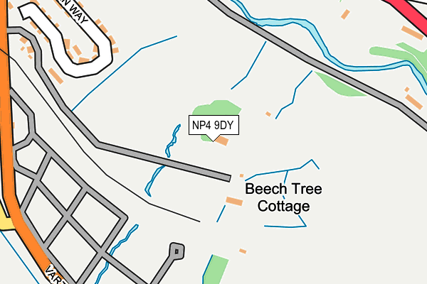
NP4 9DY lies on Varteg Road in Blaenavon, Pontypool. NP4 9DY is located in the Blaenavon electoral ward, within the unitary authority of Torfaen and the Welsh Parliamentary constituency of Torfaen. The Local Health Board is Aneurin Bevan University and the police force is Gwent. This postcode has been in use since January 1980.


GetTheData
Source: OS OpenMap – Local (Ordnance Survey)
Source: OS VectorMap District (Ordnance Survey)
Licence: Open Government Licence (requires attribution)
| Easting | 325591 |
| Northing | 208123 |
| Latitude | 51.766824 |
| Longitude | -3.079679 |
GetTheData
Source: Open Postcode Geo
Licence: Open Government Licence
| Street | Varteg Road |
| Locality | Blaenavon |
| Town/City | Pontypool |
| Country | Wales |
| Postcode District | NP4 |
| ➜ NP4 open data dashboard ➜ See where NP4 is on a map | |
GetTheData
Source: Land Registry Price Paid Data
Licence: Open Government Licence
Elevation or altitude of NP4 9DY as distance above sea level:
| Metres | Feet | |
|---|---|---|
| Elevation | 320m | 1,050ft |
Elevation is measured from the approximate centre of the postcode, to the nearest point on an OS contour line from OS Terrain 50, which has contour spacing of ten vertical metres.
➜ How high above sea level am I? Find the elevation of your current position using your device's GPS.
GetTheData
Source: Open Postcode Elevation
Licence: Open Government Licence
| Ward | Blaenavon |
| Constituency | Torfaen |
GetTheData
Source: ONS Postcode Database
Licence: Open Government Licence
| June 2022 | Public order | On or near Capel Newydd Avenue | 418m |
| June 2022 | Other theft | On or near Capel Newydd Avenue | 418m |
| June 2022 | Violence and sexual offences | On or near Capel Newydd Avenue | 418m |
| ➜ Get more crime data in our Crime section | |||
GetTheData
Source: data.police.uk
Licence: Open Government Licence
| Cemetery (Varteg Road) | Forgeside | 293m |
| Cemetery (Varteg Road) | Forgeside | 301m |
| Glenside (Cwmavon Road) | Coedcae | 317m |
| Glenside (Cwmavon Road) | Coedcae | 331m |
| Capel Newydd (Capel Newydd Avenue) | Coedcae | 408m |
GetTheData
Source: NaPTAN
Licence: Open Government Licence
| Percentage of properties with Next Generation Access | 100.0% |
| Percentage of properties with Superfast Broadband | 100.0% |
| Percentage of properties with Ultrafast Broadband | 0.0% |
| Percentage of properties with Full Fibre Broadband | 0.0% |
Superfast Broadband is between 30Mbps and 300Mbps
Ultrafast Broadband is > 300Mbps
| Percentage of properties unable to receive 2Mbps | 0.0% |
| Percentage of properties unable to receive 5Mbps | 0.0% |
| Percentage of properties unable to receive 10Mbps | 0.0% |
| Percentage of properties unable to receive 30Mbps | 0.0% |
GetTheData
Source: Ofcom
Licence: Ofcom Terms of Use (requires attribution)
Estimated total energy consumption in NP4 9DY by fuel type, 2015.
| Consumption (kWh) | 29,521 |
|---|---|
| Meter count | 6 |
| Mean (kWh/meter) | 4,920 |
| Median (kWh/meter) | 4,930 |
GetTheData
Source: Postcode level gas estimates: 2015 (experimental)
Source: Postcode level electricity estimates: 2015 (experimental)
Licence: Open Government Licence
GetTheData
Source: ONS Postcode Database
Licence: Open Government Licence


➜ Get more ratings from the Food Standards Agency
GetTheData
Source: Food Standards Agency
Licence: FSA terms & conditions
| Last Collection | |||
|---|---|---|---|
| Location | Mon-Fri | Sat | Distance |
| Bryn Terrace | 16:15 | 11:30 | 785m |
| King Street Post Office | 16:45 | 12:00 | 6,229m |
GetTheData
Source: Dracos
Licence: Creative Commons Attribution-ShareAlike
| School | Phase of Education | Distance |
|---|---|---|
| Ysgol Bryn Onnen Varteg Road, Pontypool, Torfaen, NP4 7RT | Not applicable | 3.1km |
| Garnteg Primary School Hillcrest, Garndiffaith, Pontypool, Torfaen, NP4 7SJ | Not applicable | 3.4km |
| Abersychan Comprehensive School Incline Road, Abersychan, Pontypool, Torfaen, NP4 7DF | Not applicable | 4.6km |
GetTheData
Source: Edubase
Licence: Open Government Licence
The below table lists the International Territorial Level (ITL) codes (formerly Nomenclature of Territorial Units for Statistics (NUTS) codes) and Local Administrative Units (LAU) codes for NP4 9DY:
| ITL 1 Code | Name |
|---|---|
| TLL | Wales |
| ITL 2 Code | Name |
| TLL1 | West Wales and The Valleys |
| ITL 3 Code | Name |
| TLL16 | Gwent Valleys |
| LAU 1 Code | Name |
| W06000020 | Torfaen |
GetTheData
Source: ONS Postcode Directory
Licence: Open Government Licence
The below table lists the Census Output Area (OA), Lower Layer Super Output Area (LSOA), and Middle Layer Super Output Area (MSOA) for NP4 9DY:
| Code | Name | |
|---|---|---|
| OA | W00007766 | |
| LSOA | W01001487 | Torfaen 001A |
| MSOA | W02000323 | Torfaen 001 |
GetTheData
Source: ONS Postcode Directory
Licence: Open Government Licence
| NP4 9EB | Sycamore Road | 279m |
| NP4 9AY | Horse Shoe Row | 283m |
| NP4 9LF | Cwmavon Road | 315m |
| NP4 9LG | Capel Newydd Avenue | 369m |
| NP4 9LE | Cwmavon Road | 371m |
| NP4 9LQ | Coed Eithen Terrace | 388m |
| NP4 9LR | Capel Newydd Avenue | 397m |
| NP4 9AT | Avon Road | 414m |
| NP4 9LH | Griffin Avenue | 425m |
| NP4 9LP | Capel Newydd Avenue | 425m |
GetTheData
Source: Open Postcode Geo; Land Registry Price Paid Data
Licence: Open Government Licence