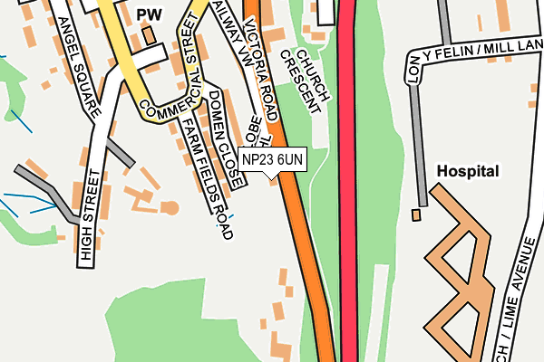
NP23 6UN lies on Victoria Road in Ebbw Vale. NP23 6UN is located in the Ebbw Vale South electoral ward, within the unitary authority of Blaenau Gwent and the Welsh Parliamentary constituency of Blaenau Gwent. The Local Health Board is Aneurin Bevan University and the police force is Gwent. This postcode has been in use since June 1999.


GetTheData
Source: OS OpenMap – Local (Ordnance Survey)
Source: OS VectorMap District (Ordnance Survey)
Licence: Open Government Licence (requires attribution)
| Easting | 316880 |
| Northing | 208529 |
| Latitude | 51.769242 |
| Longitude | -3.205973 |
GetTheData
Source: Open Postcode Geo
Licence: Open Government Licence
| Street | Victoria Road |
| Town/City | Ebbw Vale |
| Country | Wales |
| Postcode District | NP23 |
| ➜ NP23 open data dashboard ➜ See where NP23 is on a map ➜ Where is Ebbw Vale? | |
GetTheData
Source: Land Registry Price Paid Data
Licence: Open Government Licence
Elevation or altitude of NP23 6UN as distance above sea level:
| Metres | Feet | |
|---|---|---|
| Elevation | 310m | 1,017ft |
Elevation is measured from the approximate centre of the postcode, to the nearest point on an OS contour line from OS Terrain 50, which has contour spacing of ten vertical metres.
➜ How high above sea level am I? Find the elevation of your current position using your device's GPS.
GetTheData
Source: Open Postcode Elevation
Licence: Open Government Licence
| Ward | Ebbw Vale South |
| Constituency | Blaenau Gwent |
GetTheData
Source: ONS Postcode Database
Licence: Open Government Licence
| June 2022 | Public order | On or near Railway View | 153m |
| June 2022 | Violence and sexual offences | On or near Railway View | 153m |
| June 2022 | Public order | On or near High Street | 200m |
| ➜ Get more crime data in our Crime section | |||
GetTheData
Source: data.police.uk
Licence: Open Government Licence
| Rtb Club (Commercial Street) | Briery Hill | 179m |
| Rtb Club (Commercial Street) | Briery Hill | 198m |
| Ysbyty Aneurin Bevan (Lime Avenue) | Ebbw Vale | 290m |
| Ysbyty Aneurin Bevan (Lime Avenue) | Ebbw Vale | 327m |
| Festival Drive North (Park Road) | Garden City | 332m |
| Ebbw Vale Town Station | 0.9km |
| Ebbw Vale Parkway Station | 1.5km |
GetTheData
Source: NaPTAN
Licence: Open Government Licence
Estimated total energy consumption in NP23 6UN by fuel type, 2015.
| Consumption (kWh) | 141,641 |
|---|---|
| Meter count | 13 |
| Mean (kWh/meter) | 10,895 |
| Median (kWh/meter) | 11,959 |
GetTheData
Source: Postcode level gas estimates: 2015 (experimental)
Source: Postcode level electricity estimates: 2015 (experimental)
Licence: Open Government Licence
GetTheData
Source: ONS Postcode Database
Licence: Open Government Licence


➜ Get more ratings from the Food Standards Agency
GetTheData
Source: Food Standards Agency
Licence: FSA terms & conditions
| Last Collection | |||
|---|---|---|---|
| Location | Mon-Fri | Sat | Distance |
| Alma Street | 16:45 | 11:45 | 471m |
| Marine Street | 16:30 | 11:00 | 4,052m |
| King Street Post Office | 16:45 | 12:00 | 5,634m |
GetTheData
Source: Dracos
Licence: Creative Commons Attribution-ShareAlike
| School | Phase of Education | Distance |
|---|---|---|
| Pen-Y-Cwm Special School Strand Annealing Lane, Ebbw Vale, NP23 6AN | Not applicable | 556m |
| Willowtown Primary School Brynheulog Street, Willowtown, Ebbw Vale, Blaenau Gwent, NP23 6NJ | Not applicable | 1.5km |
| All Saints R.C. Primary School Heol Yr Ysgol, Ebbw Vale, Blaenau Gwent, NP23 6QP | Not applicable | 1.5km |
GetTheData
Source: Edubase
Licence: Open Government Licence
The below table lists the International Territorial Level (ITL) codes (formerly Nomenclature of Territorial Units for Statistics (NUTS) codes) and Local Administrative Units (LAU) codes for NP23 6UN:
| ITL 1 Code | Name |
|---|---|
| TLL | Wales |
| ITL 2 Code | Name |
| TLL1 | West Wales and The Valleys |
| ITL 3 Code | Name |
| TLL16 | Gwent Valleys |
| LAU 1 Code | Name |
| W06000019 | Blaenau Gwent |
GetTheData
Source: ONS Postcode Directory
Licence: Open Government Licence
The below table lists the Census Output Area (OA), Lower Layer Super Output Area (LSOA), and Middle Layer Super Output Area (MSOA) for NP23 6UN:
| Code | Name | |
|---|---|---|
| OA | W00007623 | |
| LSOA | W01001460 | Blaenau Gwent 007E |
| MSOA | W02000320 | Blaenau Gwent 007 |
GetTheData
Source: ONS Postcode Directory
Licence: Open Government Licence
| NP23 6BT | Farm Fields Road | 100m |
| NP23 6UL | Railway View | 166m |
| NP23 6BP | High Street | 195m |
| NP23 6BU | High Street | 214m |
| NP23 6BX | Zion Street | 220m |
| NP23 6BZ | Angel Square | 239m |
| NP23 6BY | 253m | |
| NP23 6EB | The Bungalows | 266m |
| NP23 6UJ | Spencer Street | 269m |
| NP23 6DB | Drysiog Street | 297m |
GetTheData
Source: Open Postcode Geo; Land Registry Price Paid Data
Licence: Open Government Licence