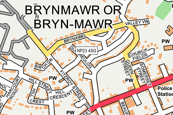
NP23 4SG is located in the Brynmawr electoral ward, within the unitary authority of Blaenau Gwent and the Welsh Parliamentary constituency of Blaenau Gwent. The Local Health Board is Aneurin Bevan University and the police force is Gwent. This postcode has been in use since June 1999.


GetTheData
Source: OS OpenMap – Local (Ordnance Survey)
Source: OS VectorMap District (Ordnance Survey)
Licence: Open Government Licence (requires attribution)
| Easting | 318880 |
| Northing | 212065 |
| Latitude | 51.801322 |
| Longitude | -3.177824 |
GetTheData
Source: Open Postcode Geo
Licence: Open Government Licence
| Country | Wales |
| Postcode District | NP23 |
| ➜ NP23 open data dashboard ➜ See where NP23 is on a map ➜ Where is Brynmawr? | |
GetTheData
Source: Land Registry Price Paid Data
Licence: Open Government Licence
Elevation or altitude of NP23 4SG as distance above sea level:
| Metres | Feet | |
|---|---|---|
| Elevation | 380m | 1,247ft |
Elevation is measured from the approximate centre of the postcode, to the nearest point on an OS contour line from OS Terrain 50, which has contour spacing of ten vertical metres.
➜ How high above sea level am I? Find the elevation of your current position using your device's GPS.
GetTheData
Source: Open Postcode Elevation
Licence: Open Government Licence
| Ward | Brynmawr |
| Constituency | Blaenau Gwent |
GetTheData
Source: ONS Postcode Database
Licence: Open Government Licence
| January 2024 | Anti-social behaviour | On or near Parking Area | 306m |
| January 2024 | Violence and sexual offences | On or near Lower Bailey Street | 373m |
| January 2024 | Violence and sexual offences | On or near Lower Bailey Street | 373m |
| ➜ Get more crime data in our Crime section | |||
GetTheData
Source: data.police.uk
Licence: Open Government Licence
| George Street Top (George Street) | Brynmawr | 355m |
| Hermitage (George Street) | Brynmawr | 356m |
| Trafalgar House (Alma Street) | Brynmawr | 574m |
| Trafalgar House (Alma Street) | Brynmawr | 576m |
| Bryn Farm Estate (King Street) | Brynmawr | 613m |
| Ebbw Vale Town Station | 3.2km |
| Ebbw Vale Parkway Station | 5.1km |
GetTheData
Source: NaPTAN
Licence: Open Government Licence
| Median download speed | 19.7Mbps |
| Average download speed | 38.0Mbps |
| Maximum download speed | 79.98Mbps |
| Median upload speed | 1.4Mbps |
| Average upload speed | 8.3Mbps |
| Maximum upload speed | 20.00Mbps |
GetTheData
Source: Ofcom
Licence: Ofcom Terms of Use (requires attribution)
Estimated total energy consumption in NP23 4SG by fuel type, 2015.
| Consumption (kWh) | 65,857 |
|---|---|
| Meter count | 10 |
| Mean (kWh/meter) | 6,586 |
| Median (kWh/meter) | 7,336 |
| Consumption (kWh) | 32,204 |
|---|---|
| Meter count | 21 |
| Mean (kWh/meter) | 1,534 |
| Median (kWh/meter) | 1,670 |
GetTheData
Source: Postcode level gas estimates: 2015 (experimental)
Source: Postcode level electricity estimates: 2015 (experimental)
Licence: Open Government Licence
GetTheData
Source: ONS Postcode Database
Licence: Open Government Licence


➜ Get more ratings from the Food Standards Agency
GetTheData
Source: Food Standards Agency
Licence: FSA terms & conditions
| Last Collection | |||
|---|---|---|---|
| Location | Mon-Fri | Sat | Distance |
| King Street Post Office | 16:45 | 12:00 | 2,157m |
| Alma Street | 16:45 | 11:45 | 4,384m |
GetTheData
Source: Dracos
Licence: Creative Commons Attribution-ShareAlike
| School | Phase of Education | Distance |
|---|---|---|
| Ysgol Gymraeg Bro Helyg Rising Sun Industrial Estate, Blaina, Blaenau Gwent, NP13 3DQ | Not applicable | 161m |
| St Mary's C in W Voluntary Aided School Intermediate Road, Brynmawr, Blaenau Gwent, NP23 4SE | Not applicable | 586m |
| St Mary's Roman Catholic - Brynmawr Catholic Road, Brynmawr, Blaenau Gwent, NP23 4EF | Not applicable | 610m |
GetTheData
Source: Edubase
Licence: Open Government Licence
The below table lists the International Territorial Level (ITL) codes (formerly Nomenclature of Territorial Units for Statistics (NUTS) codes) and Local Administrative Units (LAU) codes for NP23 4SG:
| ITL 1 Code | Name |
|---|---|
| TLL | Wales |
| ITL 2 Code | Name |
| TLL1 | West Wales and The Valleys |
| ITL 3 Code | Name |
| TLL16 | Gwent Valleys |
| LAU 1 Code | Name |
| W06000019 | Blaenau Gwent |
GetTheData
Source: ONS Postcode Directory
Licence: Open Government Licence
The below table lists the Census Output Area (OA), Lower Layer Super Output Area (LSOA), and Middle Layer Super Output Area (MSOA) for NP23 4SG:
| Code | Name | |
|---|---|---|
| OA | W00007560 | |
| LSOA | W01001449 | Blaenau Gwent 002D |
| MSOA | W02000315 | Blaenau Gwent 002 |
GetTheData
Source: ONS Postcode Directory
Licence: Open Government Licence
| NP23 4SB | Glanheulog | 56m |
| NP23 4RJ | Sunny Bank | 77m |
| NP23 4RZ | Brynawel | 86m |
| NP23 4RX | Fitzroy Street | 95m |
| NP23 4RY | Brynawel | 103m |
| NP23 4RL | Clydach Street | 105m |
| NP23 4RN | Clydach Street | 115m |
| NP23 4TA | Hill Crescent | 142m |
| NP23 4RG | King Street | 161m |
| NP23 4RD | Queen Street | 170m |
GetTheData
Source: Open Postcode Geo; Land Registry Price Paid Data
Licence: Open Government Licence