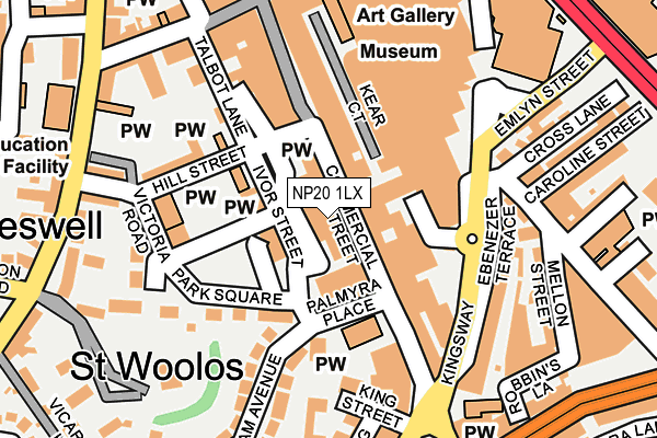
NP20 1LX lies on Commercial Street in Newport. NP20 1LX is located in the Stow Hill electoral ward, within the unitary authority of Newport and the Welsh Parliamentary constituency of Newport West. The Local Health Board is Aneurin Bevan University and the police force is Gwent. This postcode has been in use since June 1999.


GetTheData
Source: OS OpenMap – Local (Ordnance Survey)
Source: OS VectorMap District (Ordnance Survey)
Licence: Open Government Licence (requires attribution)
| Easting | 331236 |
| Northing | 187724 |
| Latitude | 51.584161 |
| Longitude | -2.993866 |
GetTheData
Source: Open Postcode Geo
Licence: Open Government Licence
| Street | Commercial Street |
| Town/City | Newport |
| Country | Wales |
| Postcode District | NP20 |
| ➜ NP20 open data dashboard ➜ See where NP20 is on a map ➜ Where is Newport? | |
GetTheData
Source: Land Registry Price Paid Data
Licence: Open Government Licence
Elevation or altitude of NP20 1LX as distance above sea level:
| Metres | Feet | |
|---|---|---|
| Elevation | 20m | 66ft |
Elevation is measured from the approximate centre of the postcode, to the nearest point on an OS contour line from OS Terrain 50, which has contour spacing of ten vertical metres.
➜ How high above sea level am I? Find the elevation of your current position using your device's GPS.
GetTheData
Source: Open Postcode Elevation
Licence: Open Government Licence
| Ward | Stow Hill |
| Constituency | Newport West |
GetTheData
Source: ONS Postcode Database
Licence: Open Government Licence
| January 2024 | Anti-social behaviour | On or near King Street | 202m |
| January 2024 | Anti-social behaviour | On or near King Street | 202m |
| January 2024 | Public order | On or near King Street | 202m |
| ➜ Commercial Street crime map and outcomes | |||
GetTheData
Source: data.police.uk
Licence: Open Government Licence
| Kingsway Centre (Ebenezer Terrace) | Newport | 146m |
| Kingsway Centre (Kingsway) | Newport | 167m |
| Ebenezer Terrace (Kingsway) | Newport | 205m |
| Police Station (Cardiff Road) | Newport | 249m |
| Stow Hill | Newport | 276m |
| Newport (S Wales) Station | 0.7km |
GetTheData
Source: NaPTAN
Licence: Open Government Licence
GetTheData
Source: ONS Postcode Database
Licence: Open Government Licence


➜ Get more ratings from the Food Standards Agency
GetTheData
Source: Food Standards Agency
Licence: FSA terms & conditions
| Last Collection | |||
|---|---|---|---|
| Location | Mon-Fri | Sat | Distance |
| Clarence Place | 17:30 | 12:00 | 127m |
| Clifton Road | 17:30 | 11:00 | 285m |
| Havelock Street | 18:30 | 11:30 | 286m |
GetTheData
Source: Dracos
Licence: Creative Commons Attribution-ShareAlike
| School | Phase of Education | Distance |
|---|---|---|
| St Woolos Primary School Stow Hill, Newport, NP20 4DW | Not applicable | 252m |
| Maindee C.P. School Rodney Road, Newport, NP19 0AP | Not applicable | 546m |
| Pillgwenlly C.P. School Capel Crescent, Newport, NP20 2FT | Not applicable | 722m |
GetTheData
Source: Edubase
Licence: Open Government Licence
The below table lists the International Territorial Level (ITL) codes (formerly Nomenclature of Territorial Units for Statistics (NUTS) codes) and Local Administrative Units (LAU) codes for NP20 1LX:
| ITL 1 Code | Name |
|---|---|
| TLL | Wales |
| ITL 2 Code | Name |
| TLL2 | East Wales |
| ITL 3 Code | Name |
| TLL21 | Monmouthshire and Newport |
| LAU 1 Code | Name |
| W06000022 | Newport |
GetTheData
Source: ONS Postcode Directory
Licence: Open Government Licence
The below table lists the Census Output Area (OA), Lower Layer Super Output Area (LSOA), and Middle Layer Super Output Area (MSOA) for NP20 1LX:
| Code | Name | |
|---|---|---|
| OA | W00008733 | |
| LSOA | W01001687 | Newport 014D |
| MSOA | W02000360 | Newport 014 |
GetTheData
Source: ONS Postcode Directory
Licence: Open Government Licence
| NP20 1LY | Commercial Street | 39m |
| NP20 1LQ | Commercial Street | 49m |
| NP20 1EW | Emlyn Walk | 58m |
| NP20 1LR | Commercial Street | 67m |
| NP20 1LW | Commercial Street | 80m |
| NP20 4EJ | Palmyra Place | 90m |
| NP20 1LZ | Hill Street | 127m |
| NP20 4EN | Park Square | 129m |
| NP20 1LN | Commercial Street | 129m |
| NP20 4EQ | Victoria Road | 144m |
GetTheData
Source: Open Postcode Geo; Land Registry Price Paid Data
Licence: Open Government Licence