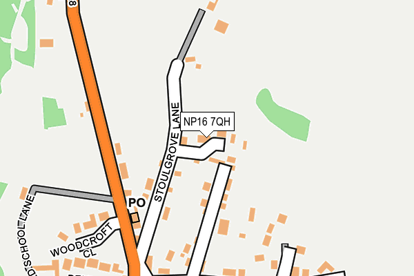
NP16 7QH lies on Stoulgrove Lane in Woodcroft, Chepstow. NP16 7QH is located in the Tidenham electoral ward, within the local authority district of Forest of Dean and the English Parliamentary constituency of Forest of Dean. The Sub Integrated Care Board (ICB) Location is NHS Gloucestershire ICB - 11M and the police force is Gloucestershire. This postcode has been in use since June 1999.


GetTheData
Source: OS OpenMap – Local (Ordnance Survey)
Source: OS VectorMap District (Ordnance Survey)
Licence: Open Government Licence (requires attribution)
| Easting | 354424 |
| Northing | 195908 |
| Latitude | 51.660096 |
| Longitude | -2.660287 |
GetTheData
Source: Open Postcode Geo
Licence: Open Government Licence
| Street | Stoulgrove Lane |
| Locality | Woodcroft |
| Town/City | Chepstow |
| Country | England |
| Postcode District | NP16 |
| ➜ NP16 open data dashboard ➜ See where NP16 is on a map ➜ Where is Woodcroft? | |
GetTheData
Source: Land Registry Price Paid Data
Licence: Open Government Licence
Elevation or altitude of NP16 7QH as distance above sea level:
| Metres | Feet | |
|---|---|---|
| Elevation | 90m | 295ft |
Elevation is measured from the approximate centre of the postcode, to the nearest point on an OS contour line from OS Terrain 50, which has contour spacing of ten vertical metres.
➜ How high above sea level am I? Find the elevation of your current position using your device's GPS.
GetTheData
Source: Open Postcode Elevation
Licence: Open Government Licence
| Ward | Tidenham |
| Constituency | Forest Of Dean |
GetTheData
Source: ONS Postcode Database
Licence: Open Government Licence
| February 2022 | Violence and sexual offences | On or near Woodcroft Lane | 218m |
| January 2022 | Anti-social behaviour | On or near Woodcroft Lane | 218m |
| October 2021 | Anti-social behaviour | On or near Woodcroft Lane | 218m |
| ➜ Stoulgrove Lane crime map and outcomes | |||
GetTheData
Source: data.police.uk
Licence: Open Government Licence
| Rising Sun (B4228) | Woodcroft | 208m |
| Rising Sun (B4228) | Woodcroft | 232m |
| Lancaut Lane (B4228) | Broadrock | 527m |
| Lancaut Lane (B4228) | Broadrock | 545m |
| Bishton Lane (B4228) | Woodcroft | 586m |
| Chepstow Station | 2.4km |
GetTheData
Source: NaPTAN
Licence: Open Government Licence
| Percentage of properties with Next Generation Access | 100.0% |
| Percentage of properties with Superfast Broadband | 100.0% |
| Percentage of properties with Ultrafast Broadband | 0.0% |
| Percentage of properties with Full Fibre Broadband | 0.0% |
Superfast Broadband is between 30Mbps and 300Mbps
Ultrafast Broadband is > 300Mbps
| Percentage of properties unable to receive 2Mbps | 0.0% |
| Percentage of properties unable to receive 5Mbps | 0.0% |
| Percentage of properties unable to receive 10Mbps | 0.0% |
| Percentage of properties unable to receive 30Mbps | 0.0% |
GetTheData
Source: Ofcom
Licence: Ofcom Terms of Use (requires attribution)
GetTheData
Source: ONS Postcode Database
Licence: Open Government Licence


➜ Get more ratings from the Food Standards Agency
GetTheData
Source: Food Standards Agency
Licence: FSA terms & conditions
| Last Collection | |||
|---|---|---|---|
| Location | Mon-Fri | Sat | Distance |
| Elm Road | 16:15 | 11:15 | 1,042m |
| Tutshill | 16:30 | 11:15 | 1,225m |
| St Annes Street | 16:00 | 12:00 | 1,845m |
GetTheData
Source: Dracos
Licence: Creative Commons Attribution-ShareAlike
| Facility | Distance |
|---|---|
| Tutshill Ce Primary School Coleford Road, Coleford Road, Tutshill, Cas-gwent Grass Pitches | 790m |
| Tidenham Recreation Ground Coleford Road, Tutshill, Chepstow Grass Pitches | 999m |
| Forest Leisure Sedbury Beachley Road, Sedbury, Cas-gwent Sports Hall, Health and Fitness Gym, Grass Pitches, Studio, Squash Courts, Outdoor Tennis Courts | 2km |
GetTheData
Source: Active Places
Licence: Open Government Licence
| School | Phase of Education | Distance |
|---|---|---|
| Tutshill Church of England Primary School Coleford Road, Tutshill, Chepstow, NP16 7BJ | Primary | 774m |
| Dean Close St John's Castleford Hill, Tutshill, Chepstow, NP16 7LE | Not applicable | 1.5km |
| Wyedean School and Sixth Form Centre Beachley Road, Sedbury, Chepstow, NP16 7AA | Secondary | 2km |
GetTheData
Source: Edubase
Licence: Open Government Licence
The below table lists the International Territorial Level (ITL) codes (formerly Nomenclature of Territorial Units for Statistics (NUTS) codes) and Local Administrative Units (LAU) codes for NP16 7QH:
| ITL 1 Code | Name |
|---|---|
| TLK | South West (England) |
| ITL 2 Code | Name |
| TLK1 | Gloucestershire, Wiltshire and Bath/Bristol area |
| ITL 3 Code | Name |
| TLK13 | Gloucestershire CC |
| LAU 1 Code | Name |
| E07000080 | Forest of Dean |
GetTheData
Source: ONS Postcode Directory
Licence: Open Government Licence
The below table lists the Census Output Area (OA), Lower Layer Super Output Area (LSOA), and Middle Layer Super Output Area (MSOA) for NP16 7QH:
| Code | Name | |
|---|---|---|
| OA | E00113238 | |
| LSOA | E01022274 | Forest of Dean 010D |
| MSOA | E02004635 | Forest of Dean 010 |
GetTheData
Source: ONS Postcode Directory
Licence: Open Government Licence
| NP16 7QE | Stoulgrove Lane | 50m |
| NP16 7PZ | 129m | |
| NP16 7HZ | 130m | |
| NP16 7JA | Sunnyside Cottages | 180m |
| NP16 7QB | Woodcroft Lane | 190m |
| NP16 7HY | 244m | |
| NP16 7QA | Woodcroft Terrace | 246m |
| NP16 7HX | Woodcroft Close | 256m |
| NP16 7PY | Penmoel Row | 349m |
| NP16 7PX | 351m |
GetTheData
Source: Open Postcode Geo; Land Registry Price Paid Data
Licence: Open Government Licence