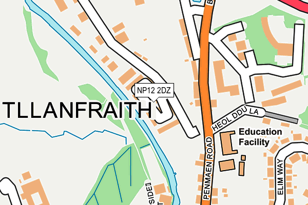
NP12 2DZ is located in the Pontllanfraith electoral ward, within the unitary authority of Caerphilly and the Welsh Parliamentary constituency of Islwyn. The Local Health Board is Aneurin Bevan University and the police force is Gwent. This postcode has been in use since June 1999.


GetTheData
Source: OS OpenMap – Local (Ordnance Survey)
Source: OS VectorMap District (Ordnance Survey)
Licence: Open Government Licence (requires attribution)
| Easting | 318072 |
| Northing | 196226 |
| Latitude | 51.658824 |
| Longitude | -3.185806 |
GetTheData
Source: Open Postcode Geo
Licence: Open Government Licence
| Country | Wales |
| Postcode District | NP12 |
| ➜ NP12 open data dashboard ➜ See where NP12 is on a map ➜ Where is Pontllanfraith? | |
GetTheData
Source: Land Registry Price Paid Data
Licence: Open Government Licence
Elevation or altitude of NP12 2DZ as distance above sea level:
| Metres | Feet | |
|---|---|---|
| Elevation | 130m | 427ft |
Elevation is measured from the approximate centre of the postcode, to the nearest point on an OS contour line from OS Terrain 50, which has contour spacing of ten vertical metres.
➜ How high above sea level am I? Find the elevation of your current position using your device's GPS.
GetTheData
Source: Open Postcode Elevation
Licence: Open Government Licence
| Ward | Pontllanfraith |
| Constituency | Islwyn |
GetTheData
Source: ONS Postcode Database
Licence: Open Government Licence
| January 2024 | Criminal damage and arson | On or near Pleasant Close | 333m |
| December 2023 | Vehicle crime | On or near Woodfield Park Crescent | 421m |
| September 2023 | Violence and sexual offences | On or near Pleasant Close | 333m |
| ➜ Get more crime data in our Crime section | |||
GetTheData
Source: data.police.uk
Licence: Open Government Licence
| Business Park (Penmaen Road) | Woodfieldside | 139m |
| Business Park (Penmaen Road) | Woodfieldside | 141m |
| Railway View (Penmaen Road) | Pontllanfraith | 246m |
| Railway View (Penmaen Road) | Pontllanfraith | 256m |
| Plough Inn (Newbridge Road) | Pontllanfraith | 313m |
| Hengoed Station | 2.9km |
| Newbridge Station | 3.1km |
| Pengam Station | 3.3km |
GetTheData
Source: NaPTAN
Licence: Open Government Licence
| Median download speed | 12.8Mbps |
| Average download speed | 12.4Mbps |
| Maximum download speed | 14.07Mbps |
| Median upload speed | 1.3Mbps |
| Average upload speed | 1.1Mbps |
| Maximum upload speed | 1.28Mbps |
GetTheData
Source: Ofcom
Licence: Ofcom Terms of Use (requires attribution)
GetTheData
Source: ONS Postcode Database
Licence: Open Government Licence


➜ Get more ratings from the Food Standards Agency
GetTheData
Source: Food Standards Agency
Licence: FSA terms & conditions
| Last Collection | |||
|---|---|---|---|
| Location | Mon-Fri | Sat | Distance |
| Blackwood Post Office | 18:00 | 12:30 | 993m |
| Pentwynmawr | 16:00 | 11:30 | 1,553m |
| Bloomfield Road Post Office | 16:00 | 11:45 | 1,560m |
GetTheData
Source: Dracos
Licence: Creative Commons Attribution-ShareAlike
| School | Phase of Education | Distance |
|---|---|---|
| Pontllanfraith Primary School Penmaen Road, Pontllanfraith, Blackwood, NP12 2DN | Not applicable | 206m |
| Libanus Primary School Libanus Rd, Blackwood, Caerphilly, NP12 1EH | Not applicable | 583m |
| Penllwyn Primary School Fleur-De-Lys Avenue, Pontllanfraith, Blackwood, NP12 2NT | Not applicable | 1.1km |
GetTheData
Source: Edubase
Licence: Open Government Licence
The below table lists the International Territorial Level (ITL) codes (formerly Nomenclature of Territorial Units for Statistics (NUTS) codes) and Local Administrative Units (LAU) codes for NP12 2DZ:
| ITL 1 Code | Name |
|---|---|
| TLL | Wales |
| ITL 2 Code | Name |
| TLL1 | West Wales and The Valleys |
| ITL 3 Code | Name |
| TLL16 | Gwent Valleys |
| LAU 1 Code | Name |
| W06000018 | Caerphilly |
GetTheData
Source: ONS Postcode Directory
Licence: Open Government Licence
The below table lists the Census Output Area (OA), Lower Layer Super Output Area (LSOA), and Middle Layer Super Output Area (MSOA) for NP12 2DZ:
| Code | Name | |
|---|---|---|
| OA | W00007340 | |
| LSOA | W01001403 | Caerphilly 011C |
| MSOA | W02000300 | Caerphilly 011 |
GetTheData
Source: ONS Postcode Directory
Licence: Open Government Licence
| NP12 2DL | Penmaen Road | 103m |
| NP12 2DQ | Penmaen Industrial Estate | 191m |
| NP12 2DN | Penmaen Road | 214m |
| NP12 2DW | Railway View | 222m |
| NP12 2GX | Heol Ddu Lane | 225m |
| NP12 2JG | Commercial Street | 246m |
| NP12 2LT | Cwrt Pantycelyn | 274m |
| NP12 2JJ | Commercial Street | 279m |
| NP12 2AA | Elim Way | 297m |
| NP12 2DJ | Woodfield Cottages | 329m |
GetTheData
Source: Open Postcode Geo; Land Registry Price Paid Data
Licence: Open Government Licence