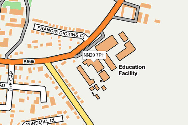
NN29 7PH is located in the Irchester electoral ward, within the unitary authority of North Northamptonshire and the English Parliamentary constituency of Wellingborough. The Sub Integrated Care Board (ICB) Location is NHS Northamptonshire ICB - 78H and the police force is Northamptonshire. This postcode has been in use since May 1994.


GetTheData
Source: OS OpenMap – Local (Ordnance Survey)
Source: OS VectorMap District (Ordnance Survey)
Licence: Open Government Licence (requires attribution)
| Easting | 491382 |
| Northing | 262915 |
| Latitude | 52.256826 |
| Longitude | -0.662636 |
GetTheData
Source: Open Postcode Geo
Licence: Open Government Licence
| Country | England |
| Postcode District | NN29 |
| ➜ NN29 open data dashboard ➜ See where NN29 is on a map ➜ Where is Wollaston? | |
GetTheData
Source: Land Registry Price Paid Data
Licence: Open Government Licence
Elevation or altitude of NN29 7PH as distance above sea level:
| Metres | Feet | |
|---|---|---|
| Elevation | 90m | 295ft |
Elevation is measured from the approximate centre of the postcode, to the nearest point on an OS contour line from OS Terrain 50, which has contour spacing of ten vertical metres.
➜ How high above sea level am I? Find the elevation of your current position using your device's GPS.
GetTheData
Source: Open Postcode Elevation
Licence: Open Government Licence
| Ward | Irchester |
| Constituency | Wellingborough |
GetTheData
Source: ONS Postcode Database
Licence: Open Government Licence
| May 2022 | Burglary | On or near Francis Dickins Close | 141m |
| May 2022 | Violence and sexual offences | On or near Stone Close | 453m |
| April 2022 | Violence and sexual offences | On or near Francis Dickins Close | 141m |
| ➜ Get more crime data in our Crime section | |||
GetTheData
Source: data.police.uk
Licence: Open Government Licence
| Wollaston School (Irchester Road) | Wollaston | 219m |
| Wollaston School (Irchester Road) | Wollaston | 221m |
| Scott Bader (Irchester Road) | Wollaston | 356m |
| Scott Bader (Irchester Road) | Wollaston | 398m |
| Holyoake Road (South Street) | Wollaston | 533m |
GetTheData
Source: NaPTAN
Licence: Open Government Licence
GetTheData
Source: ONS Postcode Database
Licence: Open Government Licence


➜ Get more ratings from the Food Standards Agency
GetTheData
Source: Food Standards Agency
Licence: FSA terms & conditions
| Last Collection | |||
|---|---|---|---|
| Location | Mon-Fri | Sat | Distance |
| Park Street | 16:30 | 08:30 | 342m |
| South Street | 16:30 | 08:30 | 517m |
| Wollaston Tso | 16:30 | 11:15 | 612m |
GetTheData
Source: Dracos
Licence: Creative Commons Attribution-ShareAlike
| Facility | Distance |
|---|---|
| Wollaston School Irchester Road, Wollaston, Wellingborough Health and Fitness Gym, Grass Pitches, Sports Hall, Studio | 0m |
| Scott Bader Swimming Pool High Street, Wollaston, Wellingborough Swimming Pool | 649m |
| Wollaston Playing Field London Road, Wollaston, Wellingborough Grass Pitches, Outdoor Tennis Courts | 1.2km |
GetTheData
Source: Active Places
Licence: Open Government Licence
| School | Phase of Education | Distance |
|---|---|---|
| Wollaston School Irchester Road, Wollaston, Wellingborough, NN29 7PH | Secondary | 0m |
| Wollaston Primary School College Street, Wollaston, Wellingborough, NN29 7SF | Primary | 613m |
| Christopher Reeves CofE VA Primary School Hinwick Road, Podington, Wellingborough, NN29 7HU | Primary | 2.7km |
GetTheData
Source: Edubase
Licence: Open Government Licence
The below table lists the International Territorial Level (ITL) codes (formerly Nomenclature of Territorial Units for Statistics (NUTS) codes) and Local Administrative Units (LAU) codes for NN29 7PH:
| ITL 1 Code | Name |
|---|---|
| TLF | East Midlands (England) |
| ITL 2 Code | Name |
| TLF2 | Leicestershire, Rutland and Northamptonshire |
| ITL 3 Code | Name |
| TLF25 | North Northamptonshire |
| LAU 1 Code | Name |
| E07000156 | Wellingborough |
GetTheData
Source: ONS Postcode Directory
Licence: Open Government Licence
The below table lists the Census Output Area (OA), Lower Layer Super Output Area (LSOA), and Middle Layer Super Output Area (MSOA) for NN29 7PH:
| Code | Name | |
|---|---|---|
| OA | E00139165 | |
| LSOA | E01027355 | Wellingborough 010F |
| MSOA | E02005701 | Wellingborough 010 |
GetTheData
Source: ONS Postcode Directory
Licence: Open Government Licence
| NN29 7RH | Francis Dickins Close | 165m |
| NN29 7RP | Irchester Road | 181m |
| NN29 7UB | The Heathers | 186m |
| NN29 7PQ | Hookhams Path | 211m |
| NN29 7SE | Windmill Close | 272m |
| NN29 7RR | Park Street | 330m |
| NN29 7RS | Eastfield Road | 331m |
| NN29 7SD | Poplar Place | 331m |
| NN29 7RW | Irchester Road | 343m |
| NN29 7RU | Eastfield Road | 344m |
GetTheData
Source: Open Postcode Geo; Land Registry Price Paid Data
Licence: Open Government Licence