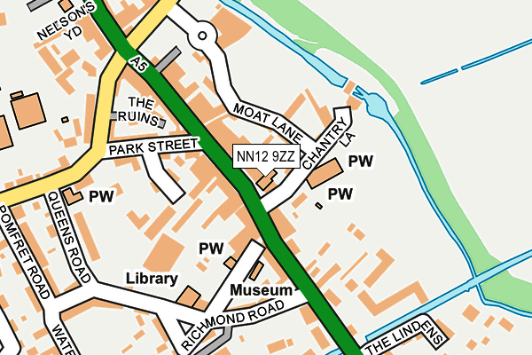
NN12 9ZZ is located in the Towcester and Roade electoral ward, within the unitary authority of West Northamptonshire and the English Parliamentary constituency of South Northamptonshire. The Sub Integrated Care Board (ICB) Location is NHS Northamptonshire ICB - 78H and the police force is Northamptonshire. This postcode has been in use since March 2016.


GetTheData
Source: OS OpenMap – Local (Ordnance Survey)
Source: OS VectorMap District (Ordnance Survey)
Licence: Open Government Licence (requires attribution)
| Easting | 469300 |
| Northing | 248872 |
| Latitude | 52.133826 |
| Longitude | -0.988934 |
GetTheData
Source: Open Postcode Geo
Licence: Open Government Licence
| Country | England |
| Postcode District | NN12 |
| ➜ NN12 open data dashboard ➜ See where NN12 is on a map ➜ Where is Towcester? | |
GetTheData
Source: Land Registry Price Paid Data
Licence: Open Government Licence
Elevation or altitude of NN12 9ZZ as distance above sea level:
| Metres | Feet | |
|---|---|---|
| Elevation | 90m | 295ft |
Elevation is measured from the approximate centre of the postcode, to the nearest point on an OS contour line from OS Terrain 50, which has contour spacing of ten vertical metres.
➜ How high above sea level am I? Find the elevation of your current position using your device's GPS.
GetTheData
Source: Open Postcode Elevation
Licence: Open Government Licence
| Ward | Towcester And Roade |
| Constituency | South Northamptonshire |
GetTheData
Source: ONS Postcode Database
Licence: Open Government Licence
| June 2023 | Anti-social behaviour | On or near The Lindens | 400m |
| May 2023 | Violence and sexual offences | On or near Police Station | 254m |
| May 2023 | Violence and sexual offences | On or near Police Station | 254m |
| ➜ Get more crime data in our Crime section | |||
GetTheData
Source: data.police.uk
Licence: Open Government Licence
| The Forum (Off Northampton Road) | Towcester | 45m |
| Central Garage (Northampton Road) | Towcester | 74m |
| Demand Responsive Area | Towcester | 142m |
| Brave Old Oak Ph (Watling Street) | Towcester | 144m |
| Brave Old Oak Ph (Watling Street West) | Towcester | 155m |
GetTheData
Source: NaPTAN
Licence: Open Government Licence
GetTheData
Source: ONS Postcode Database
Licence: Open Government Licence


➜ Get more ratings from the Food Standards Agency
GetTheData
Source: Food Standards Agency
Licence: FSA terms & conditions
| Last Collection | |||
|---|---|---|---|
| Location | Mon-Fri | Sat | Distance |
| Beaconsfield Terrace | 17:30 | 08:00 | 175m |
| Brackley Road | 17:15 | 08:30 | 321m |
| Graham Hill Towcester | 16:45 | 10:30 | 554m |
GetTheData
Source: Dracos
Licence: Creative Commons Attribution-ShareAlike
| Facility | Distance |
|---|---|
| Sponne School Brackley Road, Towcester Health and Fitness Gym, Grass Pitches, Sports Hall, Outdoor Tennis Courts | 408m |
| Towcester Recreation Ground Islington Road, Towcester Grass Pitches, Sports Hall | 497m |
| Nicholas Hawksmoor Primary School Balmoral Close, Towcester Grass Pitches | 950m |
GetTheData
Source: Active Places
Licence: Open Government Licence
| School | Phase of Education | Distance |
|---|---|---|
| Sponne School Brackley Road, Towcester, NN12 6DJ | Secondary | 333m |
| Towcester Church of England Primary School Islington Road, Towcester, NN12 6AU | Primary | 609m |
| Nicholas Hawksmoor Primary School Balmoral Close, Towcester, NN12 6JA | Primary | 950m |
GetTheData
Source: Edubase
Licence: Open Government Licence
The below table lists the International Territorial Level (ITL) codes (formerly Nomenclature of Territorial Units for Statistics (NUTS) codes) and Local Administrative Units (LAU) codes for NN12 9ZZ:
| ITL 1 Code | Name |
|---|---|
| TLF | East Midlands (England) |
| ITL 2 Code | Name |
| TLF2 | Leicestershire, Rutland and Northamptonshire |
| ITL 3 Code | Name |
| TLF24 | West Northamptonshire |
| LAU 1 Code | Name |
| E07000155 | South Northamptonshire |
GetTheData
Source: ONS Postcode Directory
Licence: Open Government Licence
The below table lists the Census Output Area (OA), Lower Layer Super Output Area (LSOA), and Middle Layer Super Output Area (MSOA) for NN12 9ZZ:
| Code | Name | |
|---|---|---|
| OA | E00169295 | |
| LSOA | E01027301 | South Northamptonshire 005D |
| MSOA | E02005685 | South Northamptonshire 005 |
GetTheData
Source: ONS Postcode Directory
Licence: Open Government Licence
| NN12 6YZ | Whittons Lane | 63m |
| NN12 6AD | Moat Lane | 88m |
| NN12 6BT | Watling Street East | 108m |
| NN12 6DQ | Park Street | 158m |
| NN12 6DB | Watling Street East | 163m |
| NN12 6YY | Chantry Lane | 167m |
| NN12 6DD | Watling Street West | 168m |
| NN12 6SY | Park Mews | 185m |
| NN12 6BX | Watling Street West | 185m |
| NN12 6DG | Nelsons Yard | 198m |
GetTheData
Source: Open Postcode Geo; Land Registry Price Paid Data
Licence: Open Government Licence