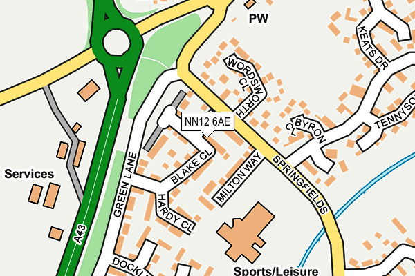
NN12 6AE is located in the Towcester and Roade electoral ward, within the unitary authority of West Northamptonshire and the English Parliamentary constituency of South Northamptonshire. The Sub Integrated Care Board (ICB) Location is NHS Northamptonshire ICB - 78H and the police force is Northamptonshire. This postcode has been in use since August 1993.


GetTheData
Source: OS OpenMap – Local (Ordnance Survey)
Source: OS VectorMap District (Ordnance Survey)
Licence: Open Government Licence (requires attribution)
| Easting | 468467 |
| Northing | 248206 |
| Latitude | 52.127930 |
| Longitude | -1.001252 |
GetTheData
Source: Open Postcode Geo
Licence: Open Government Licence
| Country | England |
| Postcode District | NN12 |
| ➜ NN12 open data dashboard ➜ See where NN12 is on a map ➜ Where is Towcester? | |
GetTheData
Source: Land Registry Price Paid Data
Licence: Open Government Licence
Elevation or altitude of NN12 6AE as distance above sea level:
| Metres | Feet | |
|---|---|---|
| Elevation | 100m | 328ft |
Elevation is measured from the approximate centre of the postcode, to the nearest point on an OS contour line from OS Terrain 50, which has contour spacing of ten vertical metres.
➜ How high above sea level am I? Find the elevation of your current position using your device's GPS.
GetTheData
Source: Open Postcode Elevation
Licence: Open Government Licence
| Ward | Towcester And Roade |
| Constituency | South Northamptonshire |
GetTheData
Source: ONS Postcode Database
Licence: Open Government Licence
| November 2023 | Violence and sexual offences | On or near Broadwater Lane | 265m |
| November 2023 | Vehicle crime | On or near Broadwater Lane | 265m |
| October 2023 | Drugs | On or near Broadwater Lane | 265m |
| ➜ Get more crime data in our Crime section | |||
GetTheData
Source: data.police.uk
Licence: Open Government Licence
| Wordsworth Close (Springfields) | Towcester | 53m |
| Wordsworth Close (Springfields) | Towcester | 63m |
| Byron Close (Buckingham Way) | Towcester | 149m |
| Byron Close (Buckingham Way) | Towcester | 168m |
| Keats Drive (Buckingham Way) | Towcester | 254m |
GetTheData
Source: NaPTAN
Licence: Open Government Licence
GetTheData
Source: ONS Postcode Database
Licence: Open Government Licence


➜ Get more ratings from the Food Standards Agency
GetTheData
Source: Food Standards Agency
Licence: FSA terms & conditions
| Last Collection | |||
|---|---|---|---|
| Location | Mon-Fri | Sat | Distance |
| Docklewell Close | 17:00 | 08:15 | 234m |
| Buckingham Road | 17:15 | 08:00 | 236m |
| Greenview Drive | 17:15 | 09:00 | 275m |
GetTheData
Source: Dracos
Licence: Creative Commons Attribution-ShareAlike
| Facility | Distance |
|---|---|
| Towcester Centre For Leisure Milton Way, Towcester Sports Hall, Swimming Pool, Health and Fitness Gym, Studio, Artificial Grass Pitch | 157m |
| Nicholas Hawksmoor Primary School Balmoral Close, Towcester Grass Pitches | 379m |
| Sponne School Brackley Road, Towcester Health and Fitness Gym, Grass Pitches, Sports Hall, Outdoor Tennis Courts | 679m |
GetTheData
Source: Active Places
Licence: Open Government Licence
| School | Phase of Education | Distance |
|---|---|---|
| Nicholas Hawksmoor Primary School Balmoral Close, Towcester, NN12 6JA | Primary | 380m |
| Sponne School Brackley Road, Towcester, NN12 6DJ | Secondary | 742m |
| Towcester Church of England Primary School Islington Road, Towcester, NN12 6AU | Primary | 1.1km |
GetTheData
Source: Edubase
Licence: Open Government Licence
The below table lists the International Territorial Level (ITL) codes (formerly Nomenclature of Territorial Units for Statistics (NUTS) codes) and Local Administrative Units (LAU) codes for NN12 6AE:
| ITL 1 Code | Name |
|---|---|
| TLF | East Midlands (England) |
| ITL 2 Code | Name |
| TLF2 | Leicestershire, Rutland and Northamptonshire |
| ITL 3 Code | Name |
| TLF24 | West Northamptonshire |
| LAU 1 Code | Name |
| E07000155 | South Northamptonshire |
GetTheData
Source: ONS Postcode Directory
Licence: Open Government Licence
The below table lists the Census Output Area (OA), Lower Layer Super Output Area (LSOA), and Middle Layer Super Output Area (MSOA) for NN12 6AE:
| Code | Name | |
|---|---|---|
| OA | E00138879 | |
| LSOA | E01027300 | South Northamptonshire 004D |
| MSOA | E02005684 | South Northamptonshire 004 |
GetTheData
Source: ONS Postcode Directory
Licence: Open Government Licence
| NN12 6JU | Wordsworth Close | 100m |
| NN12 6JT | Byron Close | 133m |
| NN12 6JG | Green Lane | 191m |
| NN12 6JZ | Shelley Close | 191m |
| NN12 6JF | Docklewell Close | 211m |
| NN12 6JY | Buckingham Way | 236m |
| NN12 6YF | Broadwater Lane | 256m |
| NN12 6TQ | Brackley Road | 263m |
| NN12 6UU | Springfields | 275m |
| NN12 6LU | Tennyson Close | 281m |
GetTheData
Source: Open Postcode Geo; Land Registry Price Paid Data
Licence: Open Government Licence