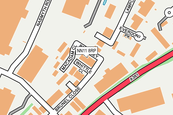
NN11 8RP lies on Brindley Close in Drayton Fields Industrial Estate, Daventry. NN11 8RP is located in the Braunston and Crick electoral ward, within the unitary authority of West Northamptonshire and the English Parliamentary constituency of Daventry. The Sub Integrated Care Board (ICB) Location is NHS Northamptonshire ICB - 78H and the police force is Northamptonshire. This postcode has been in use since September 2004.


GetTheData
Source: OS OpenMap – Local (Ordnance Survey)
Source: OS VectorMap District (Ordnance Survey)
Licence: Open Government Licence (requires attribution)
| Easting | 455944 |
| Northing | 264176 |
| Latitude | 52.272915 |
| Longitude | -1.181518 |
GetTheData
Source: Open Postcode Geo
Licence: Open Government Licence
| Street | Brindley Close |
| Locality | Drayton Fields Industrial Estate |
| Town/City | Daventry |
| Country | England |
| Postcode District | NN11 |
| ➜ NN11 open data dashboard ➜ See where NN11 is on a map ➜ Where is Daventry? | |
GetTheData
Source: Land Registry Price Paid Data
Licence: Open Government Licence
Elevation or altitude of NN11 8RP as distance above sea level:
| Metres | Feet | |
|---|---|---|
| Elevation | 150m | 492ft |
Elevation is measured from the approximate centre of the postcode, to the nearest point on an OS contour line from OS Terrain 50, which has contour spacing of ten vertical metres.
➜ How high above sea level am I? Find the elevation of your current position using your device's GPS.
GetTheData
Source: Open Postcode Elevation
Licence: Open Government Licence
| Ward | Braunston And Crick |
| Constituency | Daventry |
GetTheData
Source: ONS Postcode Database
Licence: Open Government Licence
| June 2022 | Violence and sexual offences | On or near Macadam Close | 53m |
| June 2022 | Other theft | On or near Whittle Close | 89m |
| June 2022 | Anti-social behaviour | On or near Everdon Park | 235m |
| ➜ Brindley Close crime map and outcomes | |||
GetTheData
Source: data.police.uk
Licence: Open Government Licence
| Nene House (Drayton Way) | Daventry | 228m |
| Nene House (Drayton Way) | Daventry | 267m |
| Stephenson Close (Drayton Way) | Daventry | 326m |
| Stephenson Close (Drayton Way) | Daventry | 337m |
| Dhl Offices (Newnham Drive) | Daventry | 426m |
GetTheData
Source: NaPTAN
Licence: Open Government Licence
GetTheData
Source: ONS Postcode Database
Licence: Open Government Licence


➜ Get more ratings from the Food Standards Agency
GetTheData
Source: Food Standards Agency
Licence: FSA terms & conditions
| Last Collection | |||
|---|---|---|---|
| Location | Mon-Fri | Sat | Distance |
| Prospect Way | 18:30 | 913m | |
| Churchill Road | 16:00 | 09:30 | 2,664m |
| Braunstton Sub | 16:15 | 08:00 | 2,751m |
GetTheData
Source: Dracos
Licence: Creative Commons Attribution-ShareAlike
| Facility | Distance |
|---|---|
| Mayfield Park Sports Club Royal Star Drive, Daventry Sports Hall | 762m |
| Drayton Grange Fc Royal Star Drive, Daventry Grass Pitches | 763m |
| Training Shed Alvis Way, Royal Oak Industrial Estate, Daventry Health and Fitness Gym | 803m |
GetTheData
Source: Active Places
Licence: Open Government Licence
| School | Phase of Education | Distance |
|---|---|---|
| Ashby Fields Primary School Wimborne Place, Ashby Fields, Daventry, NN11 0YP | Primary | 1.4km |
| Falconer's Hill Academy Ashby Road, Daventry, NN11 0QF | Primary | 1.5km |
| The Parker E-ACT Academy Ashby Road, Daventry, NN11 0QE | Secondary | 1.5km |
GetTheData
Source: Edubase
Licence: Open Government Licence
The below table lists the International Territorial Level (ITL) codes (formerly Nomenclature of Territorial Units for Statistics (NUTS) codes) and Local Administrative Units (LAU) codes for NN11 8RP:
| ITL 1 Code | Name |
|---|---|
| TLF | East Midlands (England) |
| ITL 2 Code | Name |
| TLF2 | Leicestershire, Rutland and Northamptonshire |
| ITL 3 Code | Name |
| TLF24 | West Northamptonshire |
| LAU 1 Code | Name |
| E07000151 | Daventry |
GetTheData
Source: ONS Postcode Directory
Licence: Open Government Licence
The below table lists the Census Output Area (OA), Lower Layer Super Output Area (LSOA), and Middle Layer Super Output Area (MSOA) for NN11 8RP:
| Code | Name | |
|---|---|---|
| OA | E00169201 | |
| LSOA | E01026990 | Daventry 006C |
| MSOA | E02005624 | Daventry 006 |
GetTheData
Source: ONS Postcode Directory
Licence: Open Government Licence
| NN11 8RX | Macadam Close | 73m |
| NN11 8RQ | Whittle Close | 96m |
| NN11 8RB | Brunel Close | 196m |
| NN11 8YH | Lamport Drive | 222m |
| NN11 8YJ | Everdon Park | 315m |
| NN11 8RT | Caxton Close | 379m |
| NN11 8YL | Cottesbrooke Park | 401m |
| NN11 8XW | Rutherford Way | 418m |
| NN11 8RR | Newton Close | 429m |
| NN11 8RJ | James Watt Close | 437m |
GetTheData
Source: Open Postcode Geo; Land Registry Price Paid Data
Licence: Open Government Licence