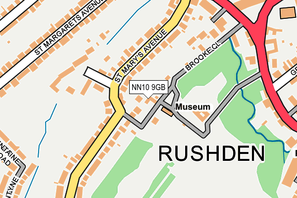
NN10 9GB is located in the Rushden Pemberton West electoral ward, within the unitary authority of North Northamptonshire and the English Parliamentary constituency of Wellingborough. The Sub Integrated Care Board (ICB) Location is NHS Northamptonshire ICB - 78H and the police force is Northamptonshire. This postcode has been in use since May 2013.


GetTheData
Source: OS OpenMap – Local (Ordnance Survey)
Source: OS VectorMap District (Ordnance Survey)
Licence: Open Government Licence (requires attribution)
| Easting | 495556 |
| Northing | 266428 |
| Latitude | 52.287705 |
| Longitude | -0.600494 |
GetTheData
Source: Open Postcode Geo
Licence: Open Government Licence
| Country | England |
| Postcode District | NN10 |
➜ See where NN10 is on a map ➜ Where is Rushden? | |
GetTheData
Source: Land Registry Price Paid Data
Licence: Open Government Licence
Elevation or altitude of NN10 9GB as distance above sea level:
| Metres | Feet | |
|---|---|---|
| Elevation | 60m | 197ft |
Elevation is measured from the approximate centre of the postcode, to the nearest point on an OS contour line from OS Terrain 50, which has contour spacing of ten vertical metres.
➜ How high above sea level am I? Find the elevation of your current position using your device's GPS.
GetTheData
Source: Open Postcode Elevation
Licence: Open Government Licence
| Ward | Rushden Pemberton West |
| Constituency | Wellingborough |
GetTheData
Source: ONS Postcode Database
Licence: Open Government Licence
2021 25 OCT £375,000 |
2019 10 MAY £410,000 |
12, HALL PARK LANE, RUSHDEN, NN10 9GB 2018 19 DEC £375,000 |
GetTheData
Source: HM Land Registry Price Paid Data
Licence: Contains HM Land Registry data © Crown copyright and database right 2025. This data is licensed under the Open Government Licence v3.0.
| Skinners Hill Layby (Skinners Hill) | Rushden | 149m |
| Skinners Hill Layby (Skinners Hill) | Rushden | 149m |
| Hall Avenue | Rushden | 169m |
| Bp Garage (High Street South) | Rushden | 170m |
| Salvation Army Citadel (Church Street) | Rushden | 203m |
GetTheData
Source: NaPTAN
Licence: Open Government Licence
| Percentage of properties with Next Generation Access | 100.0% |
| Percentage of properties with Superfast Broadband | 100.0% |
| Percentage of properties with Ultrafast Broadband | 0.0% |
| Percentage of properties with Full Fibre Broadband | 0.0% |
Superfast Broadband is between 30Mbps and 300Mbps
Ultrafast Broadband is > 300Mbps
| Percentage of properties unable to receive 2Mbps | 0.0% |
| Percentage of properties unable to receive 5Mbps | 0.0% |
| Percentage of properties unable to receive 10Mbps | 0.0% |
| Percentage of properties unable to receive 30Mbps | 0.0% |
GetTheData
Source: Ofcom
Licence: Ofcom Terms of Use (requires attribution)
GetTheData
Source: ONS Postcode Database
Licence: Open Government Licence


➜ Get more ratings from the Food Standards Agency
GetTheData
Source: Food Standards Agency
Licence: FSA terms & conditions
| Last Collection | |||
|---|---|---|---|
| Location | Mon-Fri | Sat | Distance |
| Hall Avenue | 17:30 | 11:15 | 171m |
| St Margarets Avenue | 17:30 | 11:00 | 256m |
| The Church | 17:30 | 11:45 | 290m |
GetTheData
Source: Dracos
Licence: Creative Commons Attribution-ShareAlike
The below table lists the International Territorial Level (ITL) codes (formerly Nomenclature of Territorial Units for Statistics (NUTS) codes) and Local Administrative Units (LAU) codes for NN10 9GB:
| ITL 1 Code | Name |
|---|---|
| TLF | East Midlands (England) |
| ITL 2 Code | Name |
| TLF2 | Leicestershire, Rutland and Northamptonshire |
| ITL 3 Code | Name |
| TLF25 | North Northamptonshire |
| LAU 1 Code | Name |
| E07000152 | East Northamptonshire |
GetTheData
Source: ONS Postcode Directory
Licence: Open Government Licence
The below table lists the Census Output Area (OA), Lower Layer Super Output Area (LSOA), and Middle Layer Super Output Area (MSOA) for NN10 9GB:
| Code | Name | |
|---|---|---|
| OA | E00137686 | |
| LSOA | E01027069 | East Northamptonshire 009E |
| MSOA | E02005637 | East Northamptonshire 009 |
GetTheData
Source: ONS Postcode Directory
Licence: Open Government Licence
| NN10 0XH | Brooke Close | 53m |
| NN10 9EP | St Marys Avenue | 59m |
| NN10 0UF | The Forge | 120m |
| NN10 9YE | Wellingborough Road | 135m |
| NN10 0QS | High Street South | 147m |
| NN10 9YG | Wellingborough Road | 167m |
| NN10 9YU | Church Street | 206m |
| NN10 9ER | Sandringham Close | 210m |
| NN10 9ZA | Duck Street | 221m |
| NN10 9YT | Church Street | 240m |
GetTheData
Source: Open Postcode Geo; Land Registry Price Paid Data
Licence: Open Government Licence