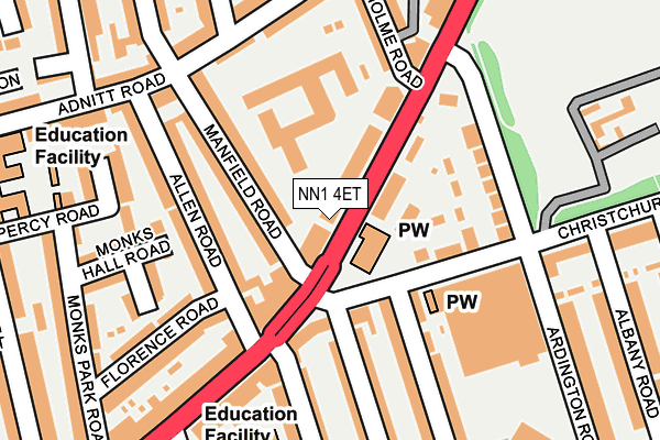
NN1 4ET is located in the Abington and Phippsville electoral ward, within the unitary authority of West Northamptonshire and the English Parliamentary constituency of Northampton North. The Sub Integrated Care Board (ICB) Location is NHS Northamptonshire ICB - 78H and the police force is Northamptonshire. This postcode has been in use since January 1980.


GetTheData
Source: OS OpenMap – Local (Ordnance Survey)
Source: OS VectorMap District (Ordnance Survey)
Licence: Open Government Licence (requires attribution)
| Easting | 477129 |
| Northing | 261295 |
| Latitude | 52.244459 |
| Longitude | -0.871755 |
GetTheData
Source: Open Postcode Geo
Licence: Open Government Licence
| Country | England |
| Postcode District | NN1 |
| ➜ NN1 open data dashboard ➜ See where NN1 is on a map ➜ Where is Northampton? | |
GetTheData
Source: Land Registry Price Paid Data
Licence: Open Government Licence
Elevation or altitude of NN1 4ET as distance above sea level:
| Metres | Feet | |
|---|---|---|
| Elevation | 90m | 295ft |
Elevation is measured from the approximate centre of the postcode, to the nearest point on an OS contour line from OS Terrain 50, which has contour spacing of ten vertical metres.
➜ How high above sea level am I? Find the elevation of your current position using your device's GPS.
GetTheData
Source: Open Postcode Elevation
Licence: Open Government Licence
| Ward | Abington And Phippsville |
| Constituency | Northampton North |
GetTheData
Source: ONS Postcode Database
Licence: Open Government Licence
| January 2024 | Burglary | On or near Supermarket | 282m |
| January 2024 | Burglary | On or near Supermarket | 282m |
| January 2024 | Burglary | On or near Parking Area | 479m |
| ➜ Get more crime data in our Crime section | |||
GetTheData
Source: data.police.uk
Licence: Open Government Licence
| Allen Road (Wellingborough Road) | Abington | 91m |
| The Abington Ph (Wellingborough Road) | Abington | 151m |
| Allen Road (Wellingborough Road) | Abington | 158m |
| The Abington Ph (Wellingborough Road) | Abington | 183m |
| Billington Street (Stimpson Avenue) | Abington | 311m |
| Northampton Station | 2.5km |
GetTheData
Source: NaPTAN
Licence: Open Government Licence
GetTheData
Source: ONS Postcode Database
Licence: Open Government Licence


➜ Get more ratings from the Food Standards Agency
GetTheData
Source: Food Standards Agency
Licence: FSA terms & conditions
| Last Collection | |||
|---|---|---|---|
| Location | Mon-Fri | Sat | Distance |
| Abington Park Tso | 17:30 | 11:30 | 91m |
| Adnitt Road | 17:30 | 11:30 | 195m |
| Barry Road | 17:30 | 12:00 | 245m |
GetTheData
Source: Dracos
Licence: Creative Commons Attribution-ShareAlike
| Facility | Distance |
|---|---|
| Barry Primary School Barry Road, Northampton Swimming Pool, Sports Hall | 250m |
| Abington Pdc Barry Road, Northampton Artificial Grass Pitch, Sports Hall, Grass Pitches | 332m |
| Northamptonshire County Ground Abington Avenue, Northampton Grass Pitches, Sports Hall | 482m |
GetTheData
Source: Active Places
Licence: Open Government Licence
| School | Phase of Education | Distance |
|---|---|---|
| Barry Primary School Barry Road, Northampton, NN1 5JS | Primary | 262m |
| Stimpson Avenue Academy Stimpson Avenue, Northampton, NN1 4LR | Primary | 313m |
| Northampton School for Boys Billing Road, Northampton, NN1 5RT | Secondary | 649m |
GetTheData
Source: Edubase
Licence: Open Government Licence
The below table lists the International Territorial Level (ITL) codes (formerly Nomenclature of Territorial Units for Statistics (NUTS) codes) and Local Administrative Units (LAU) codes for NN1 4ET:
| ITL 1 Code | Name |
|---|---|
| TLF | East Midlands (England) |
| ITL 2 Code | Name |
| TLF2 | Leicestershire, Rutland and Northamptonshire |
| ITL 3 Code | Name |
| TLF24 | West Northamptonshire |
| LAU 1 Code | Name |
| E07000154 | Northampton |
GetTheData
Source: ONS Postcode Directory
Licence: Open Government Licence
The below table lists the Census Output Area (OA), Lower Layer Super Output Area (LSOA), and Middle Layer Super Output Area (MSOA) for NN1 4ET:
| Code | Name | |
|---|---|---|
| OA | E00138050 | |
| LSOA | E01027133 | Northampton 022B |
| MSOA | E02005671 | Northampton 022 |
GetTheData
Source: ONS Postcode Directory
Licence: Open Government Licence
| NN1 4ER | Wellingborough Road | 76m |
| NN1 4RR | Roseholme Road | 88m |
| NN1 4NW | Manfield Road | 90m |
| NN1 4EX | Wellingborough Road | 103m |
| NN1 4NN | Manfield Road | 104m |
| NN1 4NE | Allen Road | 115m |
| NN1 5LL | Christchurch Road | 137m |
| NN1 4NB | Allen Road | 147m |
| NN1 5LJ | Ardington Road | 147m |
| NN1 4EP | Wellingborough Road | 178m |
GetTheData
Source: Open Postcode Geo; Land Registry Price Paid Data
Licence: Open Government Licence