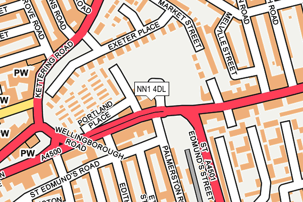
NN1 4DL is located in the Castle electoral ward, within the unitary authority of West Northamptonshire and the English Parliamentary constituency of Northampton South. The Sub Integrated Care Board (ICB) Location is NHS Northamptonshire ICB - 78H and the police force is Northamptonshire. This postcode has been in use since January 1980.


GetTheData
Source: OS OpenMap – Local (Ordnance Survey)
Source: OS VectorMap District (Ordnance Survey)
Licence: Open Government Licence (requires attribution)
| Easting | 476385 |
| Northing | 260962 |
| Latitude | 52.241569 |
| Longitude | -0.882725 |
GetTheData
Source: Open Postcode Geo
Licence: Open Government Licence
| Country | England |
| Postcode District | NN1 |
| ➜ NN1 open data dashboard ➜ See where NN1 is on a map ➜ Where is Northampton? | |
GetTheData
Source: Land Registry Price Paid Data
Licence: Open Government Licence
Elevation or altitude of NN1 4DL as distance above sea level:
| Metres | Feet | |
|---|---|---|
| Elevation | 80m | 262ft |
Elevation is measured from the approximate centre of the postcode, to the nearest point on an OS contour line from OS Terrain 50, which has contour spacing of ten vertical metres.
➜ How high above sea level am I? Find the elevation of your current position using your device's GPS.
GetTheData
Source: Open Postcode Elevation
Licence: Open Government Licence
| Ward | Castle |
| Constituency | Northampton South |
GetTheData
Source: ONS Postcode Database
Licence: Open Government Licence
| January 2024 | Anti-social behaviour | On or near Portland Place | 71m |
| January 2024 | Vehicle crime | On or near Portland Place | 71m |
| January 2024 | Violence and sexual offences | On or near Portland Place | 71m |
| ➜ Get more crime data in our Crime section | |||
GetTheData
Source: data.police.uk
Licence: Open Government Licence
| St Edmund's Street (Wellingborough Road) | Northampton | 55m |
| St Edmund's Street (Wellingborough Road) | Northampton | 108m |
| Vernon Walk (St Edmunds Street) | Northampton | 126m |
| Grove Road (Kettering Road) | Kingsley Park | 197m |
| Grove Road (Kettering Road) | Kingsley Park | 228m |
| Northampton Station | 1.7km |
GetTheData
Source: NaPTAN
Licence: Open Government Licence
GetTheData
Source: ONS Postcode Database
Licence: Open Government Licence


➜ Get more ratings from the Food Standards Agency
GetTheData
Source: Food Standards Agency
Licence: FSA terms & conditions
| Last Collection | |||
|---|---|---|---|
| Location | Mon-Fri | Sat | Distance |
| Wellingborough Road | 17:30 | 12:30 | 126m |
| Exeter Place | 17:30 | 12:30 | 205m |
| Wellingborough Road Tso | 17:30 | 12:00 | 212m |
GetTheData
Source: Dracos
Licence: Creative Commons Attribution-ShareAlike
| Facility | Distance |
|---|---|
| The Gym Group (Northampton Central) Kettering Road, Northampton Health and Fitness Gym | 293m |
| Energie Fitness (Northampton) (Closed) Abington Street, Northampton Health and Fitness Gym, Studio | 622m |
| The Polish Club Craven Street, Northampton Sports Hall | 633m |
GetTheData
Source: Active Places
Licence: Open Government Licence
| School | Phase of Education | Distance |
|---|---|---|
| Vernon Terrace Primary School Vernon Terrace, Northampton, NN1 5HE | Primary | 367m |
| Stimpson Avenue Academy Stimpson Avenue, Northampton, NN1 4LR | Primary | 573m |
| Barry Primary School Barry Road, Northampton, NN1 5JS | Primary | 647m |
GetTheData
Source: Edubase
Licence: Open Government Licence
The below table lists the International Territorial Level (ITL) codes (formerly Nomenclature of Territorial Units for Statistics (NUTS) codes) and Local Administrative Units (LAU) codes for NN1 4DL:
| ITL 1 Code | Name |
|---|---|
| TLF | East Midlands (England) |
| ITL 2 Code | Name |
| TLF2 | Leicestershire, Rutland and Northamptonshire |
| ITL 3 Code | Name |
| TLF24 | West Northamptonshire |
| LAU 1 Code | Name |
| E07000154 | Northampton |
GetTheData
Source: ONS Postcode Directory
Licence: Open Government Licence
The below table lists the Census Output Area (OA), Lower Layer Super Output Area (LSOA), and Middle Layer Super Output Area (MSOA) for NN1 4DL:
| Code | Name | |
|---|---|---|
| OA | E00138501 | |
| LSOA | E01027226 | Northampton 025C |
| MSOA | E02005674 | Northampton 025 |
GetTheData
Source: ONS Postcode Directory
Licence: Open Government Licence
| NN1 4DR | Wellingborough Road | 79m |
| NN1 4DH | Portland Place | 97m |
| NN1 5HX | Wilberforce Street | 112m |
| NN1 5ET | St Edmunds Road | 115m |
| NN1 4DT | Wellingborough Road | 123m |
| NN1 4DQ | Exeter Place | 136m |
| NN1 4DG | Exeter Place | 152m |
| NN1 4DJ | Portland Place | 154m |
| NN1 5EU | Palmerston Road | 161m |
| NN1 4BX | Market Street | 164m |
GetTheData
Source: Open Postcode Geo; Land Registry Price Paid Data
Licence: Open Government Licence