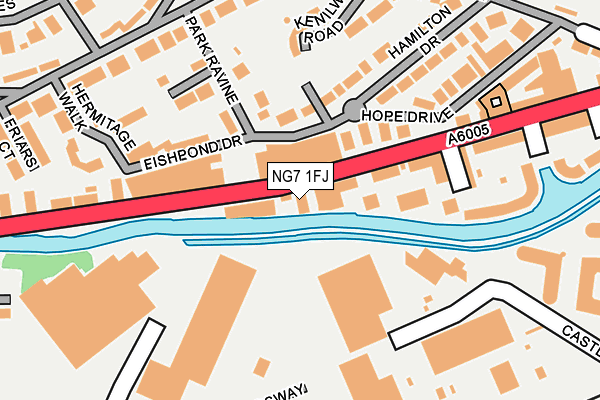
NG7 1FJ lies on Castle Boulevard in Nottingham. NG7 1FJ is located in the Castle electoral ward, within the unitary authority of Nottingham and the English Parliamentary constituency of Nottingham South. The Sub Integrated Care Board (ICB) Location is NHS Nottingham and Nottinghamshire ICB - 52R and the police force is Nottinghamshire. This postcode has been in use since January 1980.


GetTheData
Source: OS OpenMap – Local (Ordnance Survey)
Source: OS VectorMap District (Ordnance Survey)
Licence: Open Government Licence (requires attribution)
| Easting | 456588 |
| Northing | 339220 |
| Latitude | 52.947389 |
| Longitude | -1.159279 |
GetTheData
Source: Open Postcode Geo
Licence: Open Government Licence
| Street | Castle Boulevard |
| Town/City | Nottingham |
| Country | England |
| Postcode District | NG7 |
➜ See where NG7 is on a map ➜ Where is Nottingham? | |
GetTheData
Source: Land Registry Price Paid Data
Licence: Open Government Licence
Elevation or altitude of NG7 1FJ as distance above sea level:
| Metres | Feet | |
|---|---|---|
| Elevation | 30m | 98ft |
Elevation is measured from the approximate centre of the postcode, to the nearest point on an OS contour line from OS Terrain 50, which has contour spacing of ten vertical metres.
➜ How high above sea level am I? Find the elevation of your current position using your device's GPS.
GetTheData
Source: Open Postcode Elevation
Licence: Open Government Licence
| Ward | Castle |
| Constituency | Nottingham South |
GetTheData
Source: ONS Postcode Database
Licence: Open Government Licence
167, CASTLE BOULEVARD, NOTTINGHAM, NG7 1FJ 2007 15 MAR £585,000 |
GetTheData
Source: HM Land Registry Price Paid Data
Licence: Contains HM Land Registry data © Crown copyright and database right 2025. This data is licensed under the Open Government Licence v3.0.
| Palatine Street (Castle Boulevard) | Castle Marina | 175m |
| Palatine Street (Castle Boulevard) | Castle Marina | 197m |
| Ats (Castle Boulevard) | Castle Marina | 327m |
| Holiday Inn (Castle Bridge Road) | Castle Marina | 358m |
| Queens Drive (Castle Bridge Road) | Queens Drive | 409m |
| Meadows Way West Tram Stop (Meadows Way) | Meadows | 479m |
| Ng2 Tram Stop (Enterprise Way) | Lenton Lane Industrial Estate | 735m |
| Queens Walk Tram Stop (Queens Walk) | Meadows | 788m |
| Old Market Square Tram Stop (South Parade) | Nottingham | 851m |
| Nottingham Station Tram Stop (N/A) | Nottingham | 917m |
| Nottingham Station | 0.9km |
| Beeston Station | 4.4km |
| Attenborough Station | 6.7km |
GetTheData
Source: NaPTAN
Licence: Open Government Licence
GetTheData
Source: ONS Postcode Database
Licence: Open Government Licence
➜ Get more ratings from the Food Standards Agency
GetTheData
Source: Food Standards Agency
Licence: FSA terms & conditions
| Last Collection | |||
|---|---|---|---|
| Location | Mon-Fri | Sat | Distance |
| Castle Boulevard | 17:30 | 11:30 | 237m |
| Lenton Road | 17:30 | 11:00 | 245m |
| Peveril Drive | 17:30 | 11:00 | 253m |
GetTheData
Source: Dracos
Licence: Creative Commons Attribution-ShareAlike
| Risk of NG7 1FJ flooding from rivers and sea | Low |
| ➜ NG7 1FJ flood map | |
GetTheData
Source: Open Flood Risk by Postcode
Licence: Open Government Licence
The below table lists the International Territorial Level (ITL) codes (formerly Nomenclature of Territorial Units for Statistics (NUTS) codes) and Local Administrative Units (LAU) codes for NG7 1FJ:
| ITL 1 Code | Name |
|---|---|
| TLF | East Midlands (England) |
| ITL 2 Code | Name |
| TLF1 | Derbyshire and Nottinghamshire |
| ITL 3 Code | Name |
| TLF14 | Nottingham |
| LAU 1 Code | Name |
| E06000018 | Nottingham |
GetTheData
Source: ONS Postcode Directory
Licence: Open Government Licence
The below table lists the Census Output Area (OA), Lower Layer Super Output Area (LSOA), and Middle Layer Super Output Area (MSOA) for NG7 1FJ:
| Code | Name | |
|---|---|---|
| OA | E00070361 | |
| LSOA | E01032522 | Nottingham 028F |
| MSOA | E02002895 | Nottingham 028 |
GetTheData
Source: ONS Postcode Directory
Licence: Open Government Licence
| NG7 1DG | Fishpond Drive | 71m |
| NG7 1FW | Castle Quay | 74m |
| NG7 1DJ | Park Ravine | 117m |
| NG7 1FN | Castle Boulevard | 124m |
| NG7 1DH | Maria Court | 133m |
| NG7 1FZ | Kenilworth Court | 162m |
| NG7 1FF | Woodsend Wharf | 168m |
| NG7 1FG | Palatine Street | 169m |
| NG7 1DF | Hamilton Drive | 179m |
| NG7 1DD | Kenilworth Road | 202m |
GetTheData
Source: Open Postcode Geo; Land Registry Price Paid Data
Licence: Open Government Licence