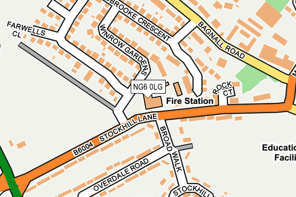
NG6 0LG is located in the Basford electoral ward, within the unitary authority of Nottingham and the English Parliamentary constituency of Nottingham North. The Sub Integrated Care Board (ICB) Location is NHS Nottingham and Nottinghamshire ICB - 52R and the police force is Nottinghamshire. This postcode has been in use since January 1980.


GetTheData
Source: OS OpenMap – Local (Ordnance Survey)
Source: OS VectorMap District (Ordnance Survey)
Licence: Open Government Licence (requires attribution)
| Easting | 454403 |
| Northing | 343214 |
| Latitude | 52.983514 |
| Longitude | -1.191124 |
GetTheData
Source: Open Postcode Geo
Licence: Open Government Licence
| Country | England |
| Postcode District | NG6 |
| ➜ NG6 open data dashboard ➜ See where NG6 is on a map ➜ Where is Nottingham? | |
GetTheData
Source: Land Registry Price Paid Data
Licence: Open Government Licence
Elevation or altitude of NG6 0LG as distance above sea level:
| Metres | Feet | |
|---|---|---|
| Elevation | 50m | 164ft |
Elevation is measured from the approximate centre of the postcode, to the nearest point on an OS contour line from OS Terrain 50, which has contour spacing of ten vertical metres.
➜ How high above sea level am I? Find the elevation of your current position using your device's GPS.
GetTheData
Source: Open Postcode Elevation
Licence: Open Government Licence
| Ward | Basford |
| Constituency | Nottingham North |
GetTheData
Source: ONS Postcode Database
Licence: Open Government Licence
| January 2024 | Violence and sexual offences | On or near Clover Green | 461m |
| June 2023 | Anti-social behaviour | On or near Bramble Close | 431m |
| March 2023 | Other theft | On or near Clover Green | 461m |
| ➜ Get more crime data in our Crime section | |||
GetTheData
Source: data.police.uk
Licence: Open Government Licence
| Basford Hall College (Stockhill Lane) | Cinderhill | 86m |
| Basford Hall College (Stockhill Lane) | Cinderhill | 98m |
| Mill Street (Stockhill Lane) | Cinderhill | 215m |
| Greenwich Avenue (Bagnall Road) | Cinderhill | 225m |
| Greenwich Avenue (Bagnall Road) | Cinderhill | 226m |
| David Lane Tram Stop (Vernon Road) | Basford | 620m |
| Highbury Vale Tram Stop (Highbury Vale) | Highbury Vale | 691m |
| Basford Tram Stop (Vernon Road) | Basford | 867m |
| Cinderhill Tram Stop (Cinderhill Road) | Cinderhill | 886m |
| Phoenix Park Tram Stop (Millennium Way East) | Phoenix Park | 1,230m |
| Bulwell Station | 1.8km |
| Nottingham Station | 5km |
GetTheData
Source: NaPTAN
Licence: Open Government Licence
GetTheData
Source: ONS Postcode Database
Licence: Open Government Licence


➜ Get more ratings from the Food Standards Agency
GetTheData
Source: Food Standards Agency
Licence: FSA terms & conditions
| Last Collection | |||
|---|---|---|---|
| Location | Mon-Fri | Sat | Distance |
| Stockhill Circus | 17:30 | 12:00 | 223m |
| Bagnall Road | 17:30 | 11:30 | 267m |
| Cinderhill | 17:00 | 09:30 | 369m |
GetTheData
Source: Dracos
Licence: Creative Commons Attribution-ShareAlike
| Facility | Distance |
|---|---|
| Stockhill Park Stockhill Lane, Nottingham Grass Pitches | 206m |
| Nuthall Recreation (Closed) Nuthall Road, Nottingham Grass Pitches | 210m |
| Old Basford School Percy Street, Nottingham Grass Pitches | 371m |
GetTheData
Source: Active Places
Licence: Open Government Licence
| School | Phase of Education | Distance |
|---|---|---|
| Old Basford School Percy Street, Old Basford, Nottingham, NG6 0GF | Primary | 364m |
| Ellis Guilford School Bar Lane, Basford, Nottingham, NG6 0HT | Secondary | 406m |
| Green Crescent School Green Academy, Queensberry Street, Basford, Nottingham, NG6 0DG | Not applicable | 824m |
GetTheData
Source: Edubase
Licence: Open Government Licence
The below table lists the International Territorial Level (ITL) codes (formerly Nomenclature of Territorial Units for Statistics (NUTS) codes) and Local Administrative Units (LAU) codes for NG6 0LG:
| ITL 1 Code | Name |
|---|---|
| TLF | East Midlands (England) |
| ITL 2 Code | Name |
| TLF1 | Derbyshire and Nottinghamshire |
| ITL 3 Code | Name |
| TLF14 | Nottingham |
| LAU 1 Code | Name |
| E06000018 | Nottingham |
GetTheData
Source: ONS Postcode Directory
Licence: Open Government Licence
The below table lists the Census Output Area (OA), Lower Layer Super Output Area (LSOA), and Middle Layer Super Output Area (MSOA) for NG6 0LG:
| Code | Name | |
|---|---|---|
| OA | E00069777 | |
| LSOA | E01013830 | Nottingham 009B |
| MSOA | E02002876 | Nottingham 009 |
GetTheData
Source: ONS Postcode Directory
Licence: Open Government Licence
| NG6 0GR | Ladbrooke Crescent | 114m |
| NG6 0JZ | Shirebrooke Close | 119m |
| NG6 0GS | Winrow Gardens | 124m |
| NG6 0LL | Broad Walk | 141m |
| NG6 0LJ | Stockhill Lane | 153m |
| NG6 0GH | Ladbrooke Crescent | 158m |
| NG6 0LH | Rock Court | 160m |
| NG6 0GL | Ladbrooke Crescent | 167m |
| NG6 0LP | Stockhill Lane | 169m |
| NG6 0LR | Overdale Road | 170m |
GetTheData
Source: Open Postcode Geo; Land Registry Price Paid Data
Licence: Open Government Licence