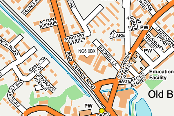
NG6 0BX is located in the Basford electoral ward, within the unitary authority of Nottingham and the English Parliamentary constituency of Nottingham North. The Sub Integrated Care Board (ICB) Location is NHS Nottingham and Nottinghamshire ICB - 52R and the police force is Nottinghamshire. This postcode has been in use since June 1997.


GetTheData
Source: OS OpenMap – Local (Ordnance Survey)
Source: OS VectorMap District (Ordnance Survey)
Licence: Open Government Licence (requires attribution)
| Easting | 454971 |
| Northing | 343539 |
| Latitude | 52.986378 |
| Longitude | -1.182609 |
GetTheData
Source: Open Postcode Geo
Licence: Open Government Licence
| Country | England |
| Postcode District | NG6 |
| ➜ NG6 open data dashboard ➜ See where NG6 is on a map ➜ Where is Nottingham? | |
GetTheData
Source: Land Registry Price Paid Data
Licence: Open Government Licence
Elevation or altitude of NG6 0BX as distance above sea level:
| Metres | Feet | |
|---|---|---|
| Elevation | 40m | 131ft |
Elevation is measured from the approximate centre of the postcode, to the nearest point on an OS contour line from OS Terrain 50, which has contour spacing of ten vertical metres.
➜ How high above sea level am I? Find the elevation of your current position using your device's GPS.
GetTheData
Source: Open Postcode Elevation
Licence: Open Government Licence
| Ward | Basford |
| Constituency | Nottingham North |
GetTheData
Source: ONS Postcode Database
Licence: Open Government Licence
| January 2024 | Violence and sexual offences | On or near Clover Green | 368m |
| November 2023 | Violence and sexual offences | On or near Park/Open Space | 282m |
| September 2023 | Theft from the person | On or near Park/Open Space | 282m |
| ➜ Get more crime data in our Crime section | |||
GetTheData
Source: data.police.uk
Licence: Open Government Licence
| Acton Avenue (Vernon Road) | Highbury Vale | 143m |
| Clare Close (Park Lane) | Highbury Vale | 152m |
| Basford Crossing (Vernon Road) | Basford | 153m |
| Acton Avenue (Vernon Road) | Highbury Vale | 168m |
| Clare Close (Park Lane) | Highbury Vale | 172m |
| David Lane Tram Stop (Vernon Road) | Basford | 170m |
| Basford Tram Stop (Vernon Road) | Basford | 590m |
| Highbury Vale Tram Stop (Highbury Vale) | Highbury Vale | 617m |
| Cinderhill Tram Stop (Cinderhill Road) | Cinderhill | 1,250m |
| Bulwell Tram Stop (Station Road) | Bulwell | 1,703m |
| Bulwell Station | 1.7km |
| Nottingham Station | 5km |
GetTheData
Source: NaPTAN
Licence: Open Government Licence
GetTheData
Source: ONS Postcode Database
Licence: Open Government Licence


➜ Get more ratings from the Food Standards Agency
GetTheData
Source: Food Standards Agency
Licence: FSA terms & conditions
| Last Collection | |||
|---|---|---|---|
| Location | Mon-Fri | Sat | Distance |
| Southwark Street | 17:30 | 11:00 | 119m |
| Skylark Drive | 17:30 | 11:00 | 285m |
| Highbury Road | 17:30 | 11:30 | 332m |
GetTheData
Source: Dracos
Licence: Creative Commons Attribution-ShareAlike
| Facility | Distance |
|---|---|
| Mill Street Recreation Ground Greenwich Avenue, Nottingham Grass Pitches, Artificial Grass Pitch | 497m |
| Old Basford School Percy Street, Nottingham Grass Pitches | 512m |
| Vernon Park Vernon Avenue, Old Basford, Nottingham Grass Pitches, Outdoor Tennis Courts | 531m |
GetTheData
Source: Active Places
Licence: Open Government Licence
| School | Phase of Education | Distance |
|---|---|---|
| Green Crescent School Green Academy, Queensberry Street, Basford, Nottingham, NG6 0DG | Not applicable | 187m |
| Southwark Primary School Park Lane, Old Basford, Nottingham, NG6 0DT | Primary | 329m |
| Old Basford School Percy Street, Old Basford, Nottingham, NG6 0GF | Primary | 532m |
GetTheData
Source: Edubase
Licence: Open Government Licence
The below table lists the International Territorial Level (ITL) codes (formerly Nomenclature of Territorial Units for Statistics (NUTS) codes) and Local Administrative Units (LAU) codes for NG6 0BX:
| ITL 1 Code | Name |
|---|---|
| TLF | East Midlands (England) |
| ITL 2 Code | Name |
| TLF1 | Derbyshire and Nottinghamshire |
| ITL 3 Code | Name |
| TLF14 | Nottingham |
| LAU 1 Code | Name |
| E06000018 | Nottingham |
GetTheData
Source: ONS Postcode Directory
Licence: Open Government Licence
The below table lists the Census Output Area (OA), Lower Layer Super Output Area (LSOA), and Middle Layer Super Output Area (MSOA) for NG6 0BX:
| Code | Name | |
|---|---|---|
| OA | E00069774 | |
| LSOA | E01013836 | Nottingham 008E |
| MSOA | E02002875 | Nottingham 008 |
GetTheData
Source: ONS Postcode Directory
Licence: Open Government Licence
| NG6 0AT | Vernon Road | 0m |
| NG6 0BT | Bulwell Lane | 47m |
| NG6 0AX | Burnaby Street | 69m |
| NG6 0AW | Vernon Road | 115m |
| NG6 0DD | Clare Close | 140m |
| NG6 0DA | Southwark Street | 141m |
| NG6 0DF | Rosebery Street | 164m |
| NG6 0NF | Swallow Close | 166m |
| NG6 0NG | Corncrake Avenue | 173m |
| NG6 0BS | Bulwell Lane | 177m |
GetTheData
Source: Open Postcode Geo; Land Registry Price Paid Data
Licence: Open Government Licence