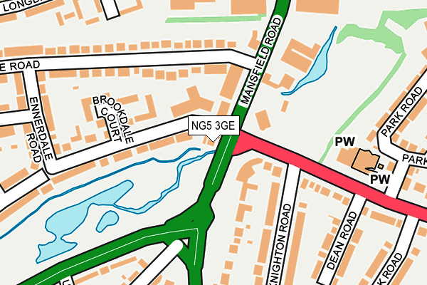
NG5 3GE is located in the Sherwood electoral ward, within the unitary authority of Nottingham and the English Parliamentary constituency of Nottingham East. The Sub Integrated Care Board (ICB) Location is NHS Nottingham and Nottinghamshire ICB - 52R and the police force is Nottinghamshire. This postcode has been in use since January 1980.


GetTheData
Source: OS OpenMap – Local (Ordnance Survey)
Source: OS VectorMap District (Ordnance Survey)
Licence: Open Government Licence (requires attribution)
| Easting | 457860 |
| Northing | 344361 |
| Latitude | 52.993482 |
| Longitude | -1.139430 |
GetTheData
Source: Open Postcode Geo
Licence: Open Government Licence
| Country | England |
| Postcode District | NG5 |
➜ See where NG5 is on a map ➜ Where is Nottingham? | |
GetTheData
Source: Land Registry Price Paid Data
Licence: Open Government Licence
Elevation or altitude of NG5 3GE as distance above sea level:
| Metres | Feet | |
|---|---|---|
| Elevation | 60m | 197ft |
Elevation is measured from the approximate centre of the postcode, to the nearest point on an OS contour line from OS Terrain 50, which has contour spacing of ten vertical metres.
➜ How high above sea level am I? Find the elevation of your current position using your device's GPS.
GetTheData
Source: Open Postcode Elevation
Licence: Open Government Licence
| Ward | Sherwood |
| Constituency | Nottingham East |
GetTheData
Source: ONS Postcode Database
Licence: Open Government Licence
| The Vale (Mansfield Road) | Daybrook | 46m |
| The Vale (Mansfield Road) | Daybrook | 61m |
| The Vale (Thackerays Lane) | Daybrook | 105m |
| The Vale (Thackerays Lane) | Daybrook | 115m |
| Mansfield Road (Valley Road) | Sherwood | 156m |
| Bulwell Station | 3.9km |
| Carlton Station | 5.2km |
| Netherfield Station | 5.4km |
GetTheData
Source: NaPTAN
Licence: Open Government Licence
GetTheData
Source: ONS Postcode Database
Licence: Open Government Licence


➜ Get more ratings from the Food Standards Agency
GetTheData
Source: Food Standards Agency
Licence: FSA terms & conditions
| Last Collection | |||
|---|---|---|---|
| Location | Mon-Fri | Sat | Distance |
| Rushcliffe Rise | 17:30 | 10:30 | 269m |
| Bedale Road | 17:30 | 11:30 | 292m |
| Longdale Road | 17:30 | 11:00 | 352m |
GetTheData
Source: Dracos
Licence: Creative Commons Attribution-ShareAlike
| Risk of NG5 3GE flooding from rivers and sea | Medium |
| ➜ NG5 3GE flood map | |
GetTheData
Source: Open Flood Risk by Postcode
Licence: Open Government Licence
The below table lists the International Territorial Level (ITL) codes (formerly Nomenclature of Territorial Units for Statistics (NUTS) codes) and Local Administrative Units (LAU) codes for NG5 3GE:
| ITL 1 Code | Name |
|---|---|
| TLF | East Midlands (England) |
| ITL 2 Code | Name |
| TLF1 | Derbyshire and Nottinghamshire |
| ITL 3 Code | Name |
| TLF14 | Nottingham |
| LAU 1 Code | Name |
| E06000018 | Nottingham |
GetTheData
Source: ONS Postcode Directory
Licence: Open Government Licence
The below table lists the Census Output Area (OA), Lower Layer Super Output Area (LSOA), and Middle Layer Super Output Area (MSOA) for NG5 3GE:
| Code | Name | |
|---|---|---|
| OA | E00070507 | |
| LSOA | E01013963 | Nottingham 007A |
| MSOA | E02002874 | Nottingham 007 |
GetTheData
Source: ONS Postcode Directory
Licence: Open Government Licence
| NG5 3GA | Ribblesdale Road | 60m |
| NG5 3GF | Mansfield Road | 63m |
| NG5 3FH | Mansfield Road | 120m |
| NG5 3GL | Bedale Road | 147m |
| NG5 4HP | Thackerays Lane | 150m |
| NG5 3GD | Brookdale Court | 151m |
| NG5 4FL | Knighton Road | 159m |
| NG5 3GH | Bedale Road | 171m |
| NG5 3GY | Ribblesdale Road | 208m |
| NG5 6ET | Frobisher Gardens | 225m |
GetTheData
Source: Open Postcode Geo; Land Registry Price Paid Data
Licence: Open Government Licence