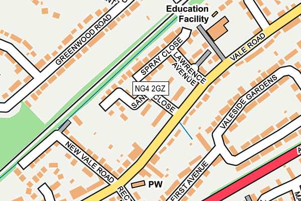
NG4 2GZ lies on Sands Close in Colwick, Nottingham. NG4 2GZ is located in the Colwick electoral ward, within the local authority district of Gedling and the English Parliamentary constituency of Gedling. The Sub Integrated Care Board (ICB) Location is NHS Nottingham and Nottinghamshire ICB - 52R and the police force is Nottinghamshire. This postcode has been in use since December 1994.


GetTheData
Source: OS OpenMap – Local (Ordnance Survey)
Source: OS VectorMap District (Ordnance Survey)
Licence: Open Government Licence (requires attribution)
| Easting | 461139 |
| Northing | 340352 |
| Latitude | 52.957066 |
| Longitude | -1.091345 |
GetTheData
Source: Open Postcode Geo
Licence: Open Government Licence
| Street | Sands Close |
| Locality | Colwick |
| Town/City | Nottingham |
| Country | England |
| Postcode District | NG4 |
➜ See where NG4 is on a map ➜ Where is Carlton? | |
GetTheData
Source: Land Registry Price Paid Data
Licence: Open Government Licence
Elevation or altitude of NG4 2GZ as distance above sea level:
| Metres | Feet | |
|---|---|---|
| Elevation | 30m | 98ft |
Elevation is measured from the approximate centre of the postcode, to the nearest point on an OS contour line from OS Terrain 50, which has contour spacing of ten vertical metres.
➜ How high above sea level am I? Find the elevation of your current position using your device's GPS.
GetTheData
Source: Open Postcode Elevation
Licence: Open Government Licence
| Ward | Colwick |
| Constituency | Gedling |
GetTheData
Source: ONS Postcode Database
Licence: Open Government Licence
| New Vale Road (Vale Road) | Colwick | 138m |
| St John School (Vale Road) | Colwick | 174m |
| Greenwood Crescent (Greenwood Road) | Bakersfield | 202m |
| St John School (Vale Road) | Colwick | 211m |
| Mays Avenue (Greenwood Road) | Bakersfield | 218m |
| Netherfield Station | 0.9km |
| Carlton Station | 1.2km |
| Radcliffe (Notts) Station | 3.7km |
GetTheData
Source: NaPTAN
Licence: Open Government Licence
| Percentage of properties with Next Generation Access | 100.0% |
| Percentage of properties with Superfast Broadband | 100.0% |
| Percentage of properties with Ultrafast Broadband | 100.0% |
| Percentage of properties with Full Fibre Broadband | 100.0% |
Superfast Broadband is between 30Mbps and 300Mbps
Ultrafast Broadband is > 300Mbps
| Median download speed | 69.7Mbps |
| Average download speed | 91.9Mbps |
| Maximum download speed | 350.00Mbps |
| Median upload speed | 10.0Mbps |
| Average upload speed | 9.4Mbps |
| Maximum upload speed | 20.00Mbps |
| Percentage of properties unable to receive 2Mbps | 0.0% |
| Percentage of properties unable to receive 5Mbps | 0.0% |
| Percentage of properties unable to receive 10Mbps | 0.0% |
| Percentage of properties unable to receive 30Mbps | 0.0% |
GetTheData
Source: Ofcom
Licence: Ofcom Terms of Use (requires attribution)
Estimated total energy consumption in NG4 2GZ by fuel type, 2015.
| Consumption (kWh) | 512,370 |
|---|---|
| Meter count | 52 |
| Mean (kWh/meter) | 9,853 |
| Median (kWh/meter) | 9,047 |
| Consumption (kWh) | 192,364 |
|---|---|
| Meter count | 52 |
| Mean (kWh/meter) | 3,699 |
| Median (kWh/meter) | 3,597 |
GetTheData
Source: Postcode level gas estimates: 2015 (experimental)
Source: Postcode level electricity estimates: 2015 (experimental)
Licence: Open Government Licence
GetTheData
Source: ONS Postcode Database
Licence: Open Government Licence


➜ Get more ratings from the Food Standards Agency
GetTheData
Source: Food Standards Agency
Licence: FSA terms & conditions
| Last Collection | |||
|---|---|---|---|
| Location | Mon-Fri | Sat | Distance |
| Vale Road | 17:30 | 11:00 | 180m |
| Mayes Avenue | 17:30 | 12:00 | 270m |
| Mile End Road | 17:30 | 11:00 | 476m |
GetTheData
Source: Dracos
Licence: Creative Commons Attribution-ShareAlike
| Risk of NG4 2GZ flooding from rivers and sea | Low |
| ➜ NG4 2GZ flood map | |
GetTheData
Source: Open Flood Risk by Postcode
Licence: Open Government Licence
The below table lists the International Territorial Level (ITL) codes (formerly Nomenclature of Territorial Units for Statistics (NUTS) codes) and Local Administrative Units (LAU) codes for NG4 2GZ:
| ITL 1 Code | Name |
|---|---|
| TLF | East Midlands (England) |
| ITL 2 Code | Name |
| TLF1 | Derbyshire and Nottinghamshire |
| ITL 3 Code | Name |
| TLF16 | South Nottinghamshire |
| LAU 1 Code | Name |
| E07000173 | Gedling |
GetTheData
Source: ONS Postcode Directory
Licence: Open Government Licence
The below table lists the Census Output Area (OA), Lower Layer Super Output Area (LSOA), and Middle Layer Super Output Area (MSOA) for NG4 2GZ:
| Code | Name | |
|---|---|---|
| OA | E00143624 | |
| LSOA | E01028188 | Gedling 015E |
| MSOA | E02005879 | Gedling 015 |
GetTheData
Source: ONS Postcode Directory
Licence: Open Government Licence
| NG4 2ED | Vale Road | 96m |
| NG4 2GT | Spray Close | 96m |
| NG4 2GP | Vale Road | 107m |
| NG4 2GS | Lawrence Avenue | 108m |
| NG4 2DX | First Avenue | 158m |
| NG4 1AR | Greenwood Road | 165m |
| NG4 2EL | Valeside Gardens | 181m |
| NG4 2EA | Newvale Road | 200m |
| NG4 1AP | Greenwood Road | 207m |
| NG4 2EB | Vale Road | 226m |
GetTheData
Source: Open Postcode Geo; Land Registry Price Paid Data
Licence: Open Government Licence