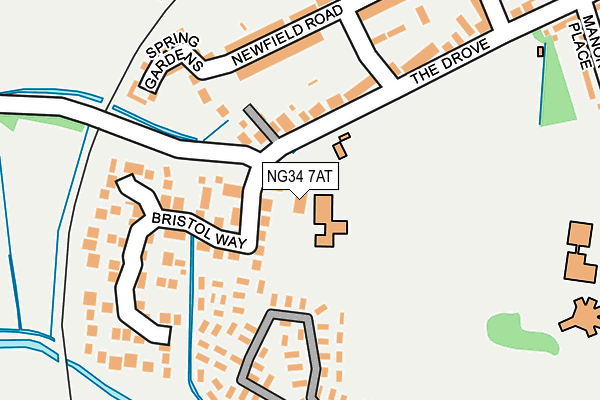
NG34 7AT is located in the Sleaford Westholme electoral ward, within the local authority district of North Kesteven and the English Parliamentary constituency of Sleaford and North Hykeham. The Sub Integrated Care Board (ICB) Location is NHS Lincolnshire ICB - 71E and the police force is Lincolnshire. This postcode has been in use since January 1980.


GetTheData
Source: OS OpenMap – Local (Ordnance Survey)
Source: OS VectorMap District (Ordnance Survey)
Licence: Open Government Licence (requires attribution)
| Easting | 506160 |
| Northing | 346093 |
| Latitude | 53.001666 |
| Longitude | -0.419503 |
GetTheData
Source: Open Postcode Geo
Licence: Open Government Licence
| Country | England |
| Postcode District | NG34 |
| ➜ NG34 open data dashboard ➜ See where NG34 is on a map ➜ Where is Sleaford? | |
GetTheData
Source: Land Registry Price Paid Data
Licence: Open Government Licence
Elevation or altitude of NG34 7AT as distance above sea level:
| Metres | Feet | |
|---|---|---|
| Elevation | 20m | 66ft |
Elevation is measured from the approximate centre of the postcode, to the nearest point on an OS contour line from OS Terrain 50, which has contour spacing of ten vertical metres.
➜ How high above sea level am I? Find the elevation of your current position using your device's GPS.
GetTheData
Source: Open Postcode Elevation
Licence: Open Government Licence
| Ward | Sleaford Westholme |
| Constituency | Sleaford And North Hykeham |
GetTheData
Source: ONS Postcode Database
Licence: Open Government Licence
| August 2022 | Anti-social behaviour | On or near Bristol Way | 157m |
| August 2022 | Vehicle crime | On or near Bristol Way | 157m |
| August 2022 | Anti-social behaviour | On or near Bristol Way | 157m |
| ➜ Get more crime data in our Crime section | |||
GetTheData
Source: data.police.uk
Licence: Open Government Licence
| Newfield Road (The Drove) | Sleaford | 162m |
| West Banks (Castle Causeway) | Sleaford | 380m |
| Manor Place (The Drove) | Sleaford | 385m |
| Manor Place (The Drove) | Sleaford | 401m |
| North Parade | Sleaford | 416m |
| Sleaford Station | 0.9km |
| Rauceby Station | 3.1km |
| Ruskington Station | 5.1km |
GetTheData
Source: NaPTAN
Licence: Open Government Licence
GetTheData
Source: ONS Postcode Database
Licence: Open Government Licence


➜ Get more ratings from the Food Standards Agency
GetTheData
Source: Food Standards Agency
Licence: FSA terms & conditions
| Last Collection | |||
|---|---|---|---|
| Location | Mon-Fri | Sat | Distance |
| West Banks | 16:30 | 11:00 | 407m |
| Tesco | 17:30 | 11:15 | 511m |
| Tennyson Avenue | 17:45 | 11:15 | 522m |
GetTheData
Source: Dracos
Licence: Creative Commons Attribution-ShareAlike
| Facility | Distance |
|---|---|
| St Georges Academy (Sleaford Site) Westgate, Sleaford Sports Hall, Health and Fitness Gym, Grass Pitches, Artificial Grass Pitch, Outdoor Tennis Courts | 450m |
| Carre's Grammar School Northgate, Sleaford Sports Hall, Health and Fitness Gym, Grass Pitches, Artificial Grass Pitch, Outdoor Tennis Courts | 605m |
| New Image Gym Church Lane, Sleaford Health and Fitness Gym, Studio | 674m |
GetTheData
Source: Active Places
Licence: Open Government Licence
| School | Phase of Education | Distance |
|---|---|---|
| Our Lady of Good Counsel Catholic Primary School, A Voluntary Academy The Drove, Sleaford, NG34 7AT | Primary | 5m |
| St George's Academy Westgate, Sleaford, NG34 7PP | Secondary | 375m |
| Sleaford Joint Sixth Form Westholme House, Leicester Street, Sleaford, NG34 7PS | Not applicable | 426m |
GetTheData
Source: Edubase
Licence: Open Government Licence
The below table lists the International Territorial Level (ITL) codes (formerly Nomenclature of Territorial Units for Statistics (NUTS) codes) and Local Administrative Units (LAU) codes for NG34 7AT:
| ITL 1 Code | Name |
|---|---|
| TLF | East Midlands (England) |
| ITL 2 Code | Name |
| TLF3 | Lincolnshire |
| ITL 3 Code | Name |
| TLF30 | Lincolnshire CC |
| LAU 1 Code | Name |
| E07000139 | North Kesteven |
GetTheData
Source: ONS Postcode Directory
Licence: Open Government Licence
The below table lists the Census Output Area (OA), Lower Layer Super Output Area (LSOA), and Middle Layer Super Output Area (MSOA) for NG34 7AT:
| Code | Name | |
|---|---|---|
| OA | E00169381 | |
| LSOA | E01026236 | North Kesteven 011E |
| MSOA | E02005463 | North Kesteven 011 |
GetTheData
Source: ONS Postcode Directory
Licence: Open Government Licence
| NG34 7AE | Bristol Way | 110m |
| NG34 7AS | The Drove | 117m |
| NG34 7BD | Lafford Court | 166m |
| NG34 7AU | Spring Gardens | 183m |
| NG34 7BA | Meadowfield | 284m |
| NG34 7QJ | Electric Station Road | 306m |
| NG34 7AR | Manor Place | 323m |
| NG34 7AZ | Meadowfield | 360m |
| NG34 7QU | Westgate | 361m |
| NG34 7QL | Electric Station Road | 362m |
GetTheData
Source: Open Postcode Geo; Land Registry Price Paid Data
Licence: Open Government Licence