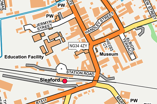
NG34 4ZY is located in the Sleaford Castle electoral ward, within the local authority district of North Kesteven and the English Parliamentary constituency of Sleaford and North Hykeham. The Sub Integrated Care Board (ICB) Location is NHS Lincolnshire ICB - 71E and the police force is Lincolnshire. This postcode has been in use since March 2016.


GetTheData
Source: OS OpenMap – Local (Ordnance Survey)
Source: OS VectorMap District (Ordnance Survey)
Licence: Open Government Licence (requires attribution)
| Easting | 506849 |
| Northing | 345515 |
| Latitude | 52.996313 |
| Longitude | -0.409437 |
GetTheData
Source: Open Postcode Geo
Licence: Open Government Licence
| Country | England |
| Postcode District | NG34 |
| ➜ NG34 open data dashboard ➜ See where NG34 is on a map | |
GetTheData
Source: Land Registry Price Paid Data
Licence: Open Government Licence
Elevation or altitude of NG34 4ZY as distance above sea level:
| Metres | Feet | |
|---|---|---|
| Elevation | 20m | 66ft |
Elevation is measured from the approximate centre of the postcode, to the nearest point on an OS contour line from OS Terrain 50, which has contour spacing of ten vertical metres.
➜ How high above sea level am I? Find the elevation of your current position using your device's GPS.
GetTheData
Source: Open Postcode Elevation
Licence: Open Government Licence
| Ward | Sleaford Castle |
| Constituency | Sleaford And North Hykeham |
GetTheData
Source: ONS Postcode Database
Licence: Open Government Licence
| January 2024 | Violence and sexual offences | On or near Parking Area | 100m |
| January 2024 | Violence and sexual offences | On or near Handley Street | 138m |
| January 2024 | Shoplifting | On or near Supermarket | 232m |
| ➜ Get more crime data in our Crime section | |||
GetTheData
Source: data.police.uk
Licence: Open Government Licence
| Yorkshire Trading (Southgate) | Sleaford | 76m |
| Rail Station (Station Road) | Sleaford | 85m |
| Hills Court (Boston Road) | Sleaford | 128m |
| Carre Arms Hotel (Mareham Lane) | Sleaford | 170m |
| Riverside Surgery (Carre Street) | Sleaford | 195m |
| Sleaford Station | 0.1km |
| Rauceby Station | 3.4km |
GetTheData
Source: NaPTAN
Licence: Open Government Licence
GetTheData
Source: ONS Postcode Database
Licence: Open Government Licence


➜ Get more ratings from the Food Standards Agency
GetTheData
Source: Food Standards Agency
Licence: FSA terms & conditions
| Last Collection | |||
|---|---|---|---|
| Location | Mon-Fri | Sat | Distance |
| Sleaford Delivery Office | 18:45 | 11:30 | 46m |
| Southgate Centre | 17:45 | 11:00 | 263m |
| Market Place | 18:30 | 10:30 | 343m |
GetTheData
Source: Dracos
Licence: Creative Commons Attribution-ShareAlike
| Facility | Distance |
|---|---|
| Kesteven And Sleaford High School Selective Academy Jermyn Street, Sleaford Grass Pitches, Sports Hall, Studio, Outdoor Tennis Courts | 118m |
| Sleaford Cricket Club London Road, Sleaford Grass Pitches | 320m |
| Sleaford Indoor Bowls Club Hussey Close, Sleaford Indoor Bowls | 479m |
GetTheData
Source: Active Places
Licence: Open Government Licence
| School | Phase of Education | Distance |
|---|---|---|
| Kesteven and Sleaford High School Selective Academy Jermyn Street, Sleaford, NG34 7RS | Secondary | 131m |
| Holton Sleaford Independent School Westgate House, Westgate, Sleaford, NG34 7RJ | Not applicable | 382m |
| Sleaford Joint Sixth Form Westholme House, Leicester Street, Sleaford, NG34 7PS | Not applicable | 483m |
GetTheData
Source: Edubase
Licence: Open Government Licence
The below table lists the International Territorial Level (ITL) codes (formerly Nomenclature of Territorial Units for Statistics (NUTS) codes) and Local Administrative Units (LAU) codes for NG34 4ZY:
| ITL 1 Code | Name |
|---|---|
| TLF | East Midlands (England) |
| ITL 2 Code | Name |
| TLF3 | Lincolnshire |
| ITL 3 Code | Name |
| TLF30 | Lincolnshire CC |
| LAU 1 Code | Name |
| E07000139 | North Kesteven |
GetTheData
Source: ONS Postcode Directory
Licence: Open Government Licence
The below table lists the Census Output Area (OA), Lower Layer Super Output Area (LSOA), and Middle Layer Super Output Area (MSOA) for NG34 4ZY:
| Code | Name | |
|---|---|---|
| OA | E00133189 | |
| LSOA | E01026227 | North Kesteven 010A |
| MSOA | E02005462 | North Kesteven 010 |
GetTheData
Source: ONS Postcode Directory
Licence: Open Government Licence
| NG34 7RP | Nags Head Passage | 44m |
| NG34 7RL | Southgate | 45m |
| NG34 7RW | Handley Court Mews | 46m |
| NG34 7TA | Southgate | 75m |
| NG34 7RR | Southgate | 100m |
| NG34 7ET | Boston Road | 106m |
| NG34 7ER | Boston Road | 116m |
| NG34 7RG | Station Road | 152m |
| NG34 7RU | Jermyn Street | 153m |
| NG34 7ES | Hamilton Place | 156m |
GetTheData
Source: Open Postcode Geo; Land Registry Price Paid Data
Licence: Open Government Licence