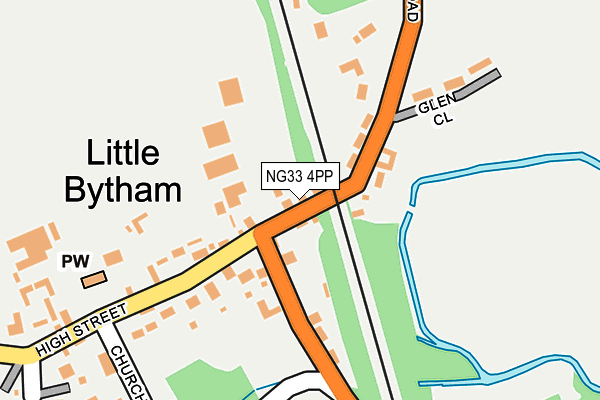
NG33 4PP lies on High Street in Little Bytham, Grantham. NG33 4PP is located in the Glen electoral ward, within the local authority district of South Kesteven and the English Parliamentary constituency of Grantham and Stamford. The Sub Integrated Care Board (ICB) Location is NHS Lincolnshire ICB - 71E and the police force is Lincolnshire. This postcode has been in use since January 1980.


GetTheData
Source: OS OpenMap – Local (Ordnance Survey)
Source: OS VectorMap District (Ordnance Survey)
Licence: Open Government Licence (requires attribution)
| Easting | 501501 |
| Northing | 318124 |
| Latitude | 52.751210 |
| Longitude | -0.497619 |
GetTheData
Source: Open Postcode Geo
Licence: Open Government Licence
| Street | High Street |
| Locality | Little Bytham |
| Town/City | Grantham |
| Country | England |
| Postcode District | NG33 |
| ➜ NG33 open data dashboard ➜ See where NG33 is on a map ➜ Where is Little Bytham? | |
GetTheData
Source: Land Registry Price Paid Data
Licence: Open Government Licence
Elevation or altitude of NG33 4PP as distance above sea level:
| Metres | Feet | |
|---|---|---|
| Elevation | 40m | 131ft |
Elevation is measured from the approximate centre of the postcode, to the nearest point on an OS contour line from OS Terrain 50, which has contour spacing of ten vertical metres.
➜ How high above sea level am I? Find the elevation of your current position using your device's GPS.
GetTheData
Source: Open Postcode Elevation
Licence: Open Government Licence
| Ward | Glen |
| Constituency | Grantham And Stamford |
GetTheData
Source: ONS Postcode Database
Licence: Open Government Licence
| December 2021 | Other theft | On or near Glen Close | 175m |
| April 2021 | Other theft | On or near New Estate | 408m |
| ➜ Get more crime data in our Crime section | |||
GetTheData
Source: data.police.uk
Licence: Open Government Licence
| The Mallard Ph (High Street) | Little Bytham | 15m |
| Demand Responsive Area | Little Bytham | 17m |
| The Mallard Ph (High Street) | Little Bytham | 18m |
| Church Lane (Station Road) | Little Bytham | 111m |
| Church Lane (Station Road) | Little Bytham | 137m |
GetTheData
Source: NaPTAN
Licence: Open Government Licence
| Percentage of properties with Next Generation Access | 100.0% |
| Percentage of properties with Superfast Broadband | 100.0% |
| Percentage of properties with Ultrafast Broadband | 0.0% |
| Percentage of properties with Full Fibre Broadband | 0.0% |
Superfast Broadband is between 30Mbps and 300Mbps
Ultrafast Broadband is > 300Mbps
| Percentage of properties unable to receive 2Mbps | 0.0% |
| Percentage of properties unable to receive 5Mbps | 0.0% |
| Percentage of properties unable to receive 10Mbps | 0.0% |
| Percentage of properties unable to receive 30Mbps | 0.0% |
GetTheData
Source: Ofcom
Licence: Ofcom Terms of Use (requires attribution)
GetTheData
Source: ONS Postcode Database
Licence: Open Government Licence


➜ Get more ratings from the Food Standards Agency
GetTheData
Source: Food Standards Agency
Licence: FSA terms & conditions
| Last Collection | |||
|---|---|---|---|
| Location | Mon-Fri | Sat | Distance |
| Careby | 16:00 | 07:30 | 1,775m |
| Holywell | 16:15 | 07:00 | 2,433m |
| Aunby | 16:00 | 07:30 | 3,601m |
GetTheData
Source: Dracos
Licence: Creative Commons Attribution-ShareAlike
| Facility | Distance |
|---|---|
| Witham Hall School Witham-on-the-hill, Bourne Sports Hall, Squash Courts, Grass Pitches, Artificial Grass Pitch, Golf, Outdoor Tennis Courts, Studio, Health and Fitness Gym | 3.8km |
| Edenham Playing Field Church Lane, Edenham, Bourne Grass Pitches | 6.3km |
GetTheData
Source: Active Places
Licence: Open Government Licence
| School | Phase of Education | Distance |
|---|---|---|
| Bythams Primary School Creeton Road, Little Bytham, Grantham, NG33 4PX | Primary | 927m |
| Witham Hall School Witham-on-the-Hill, Bourne, PE10 0JJ | Not applicable | 3.8km |
| The Edenham Church of England School School Lane, Edenham, Bourne, PE10 0LP | Primary | 6.1km |
GetTheData
Source: Edubase
Licence: Open Government Licence
The below table lists the International Territorial Level (ITL) codes (formerly Nomenclature of Territorial Units for Statistics (NUTS) codes) and Local Administrative Units (LAU) codes for NG33 4PP:
| ITL 1 Code | Name |
|---|---|
| TLF | East Midlands (England) |
| ITL 2 Code | Name |
| TLF3 | Lincolnshire |
| ITL 3 Code | Name |
| TLF30 | Lincolnshire CC |
| LAU 1 Code | Name |
| E07000141 | South Kesteven |
GetTheData
Source: ONS Postcode Directory
Licence: Open Government Licence
The below table lists the Census Output Area (OA), Lower Layer Super Output Area (LSOA), and Middle Layer Super Output Area (MSOA) for NG33 4PP:
| Code | Name | |
|---|---|---|
| OA | E00133738 | |
| LSOA | E01026330 | South Kesteven 012A |
| MSOA | E02005487 | South Kesteven 012 |
GetTheData
Source: ONS Postcode Directory
Licence: Open Government Licence
| NG33 4PR | Creeton Road | 68m |
| NG33 4PT | Creeton Road | 147m |
| NG33 4QY | Station Road | 162m |
| NG33 4PS | Glen Close | 189m |
| NG33 4QX | High Street | 197m |
| NG33 4QP | Church Lane | 260m |
| NG33 4QJ | High Street | 264m |
| NG33 4QZ | Sheepdyke Lane | 291m |
| NG33 4QL | New Estate | 437m |
| NG33 4RX | St Medards Close | 480m |
GetTheData
Source: Open Postcode Geo; Land Registry Price Paid Data
Licence: Open Government Licence