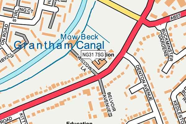
NG31 7SG is located in the Grantham Earlesfield electoral ward, within the local authority district of South Kesteven and the English Parliamentary constituency of Grantham and Stamford. The Sub Integrated Care Board (ICB) Location is NHS Lincolnshire ICB - 71E and the police force is Lincolnshire. This postcode has been in use since January 1980.


GetTheData
Source: OS OpenMap – Local (Ordnance Survey)
Source: OS VectorMap District (Ordnance Survey)
Licence: Open Government Licence (requires attribution)
| Easting | 490601 |
| Northing | 334495 |
| Latitude | 52.900270 |
| Longitude | -0.654523 |
GetTheData
Source: Open Postcode Geo
Licence: Open Government Licence
| Country | England |
| Postcode District | NG31 |
| ➜ NG31 open data dashboard ➜ See where NG31 is on a map ➜ Where is Grantham? | |
GetTheData
Source: Land Registry Price Paid Data
Licence: Open Government Licence
Elevation or altitude of NG31 7SG as distance above sea level:
| Metres | Feet | |
|---|---|---|
| Elevation | 60m | 197ft |
Elevation is measured from the approximate centre of the postcode, to the nearest point on an OS contour line from OS Terrain 50, which has contour spacing of ten vertical metres.
➜ How high above sea level am I? Find the elevation of your current position using your device's GPS.
GetTheData
Source: Open Postcode Elevation
Licence: Open Government Licence
| Ward | Grantham Earlesfield |
| Constituency | Grantham And Stamford |
GetTheData
Source: ONS Postcode Database
Licence: Open Government Licence
| February 2023 | Violence and sexual offences | On or near Hornsby Road | 399m |
| October 2022 | Violence and sexual offences | On or near Hornsby Road | 399m |
| September 2022 | Violence and sexual offences | On or near Hornsby Road | 399m |
| ➜ Get more crime data in our Crime section | |||
GetTheData
Source: data.police.uk
Licence: Open Government Licence
| Belvoir Avenue (Harlaxton Road) | Grantham | 57m |
| Belvoir Avenue (Harlaxton Road) | Grantham | 73m |
| Denton Close (Denton Avenue) | Grantham | 166m |
| Denton Close (Denton Avenue) | Grantham | 185m |
| Sir Isaac Newton Ph (Harlaxton Road) | Grantham | 253m |
| Grantham Station | 1.1km |
GetTheData
Source: NaPTAN
Licence: Open Government Licence
GetTheData
Source: ONS Postcode Database
Licence: Open Government Licence


➜ Get more ratings from the Food Standards Agency
GetTheData
Source: Food Standards Agency
Licence: FSA terms & conditions
| Last Collection | |||
|---|---|---|---|
| Location | Mon-Fri | Sat | Distance |
| Kittybriggs Lane | 17:00 | 11:45 | 301m |
| Ellesmere Business Park | 18:30 | 11:45 | 601m |
| Dysart Road Post Office | 17:00 | 12:00 | 1,123m |
GetTheData
Source: Dracos
Licence: Creative Commons Attribution-ShareAlike
| Facility | Distance |
|---|---|
| Walton Academy Kitty Briggs Lane, Grantham Sports Hall, Grass Pitches, Studio, Health and Fitness Gym | 315m |
| Urban Hotel (Grantham) Swingbridge Road, Grantham Swimming Pool, Health and Fitness Gym | 424m |
| Grantham Squash And Fitness Centre Harlaxton Road, Grantham Health and Fitness Gym, Squash Courts | 654m |
GetTheData
Source: Active Places
Licence: Open Government Licence
| School | Phase of Education | Distance |
|---|---|---|
| Walton Academy Harlaxton Road, Grantham, NG31 7JR | Secondary | 315m |
| West Grantham Church of England Primary Academy Trent Road, Grantham, NG31 7XQ | Primary | 779m |
| Huntingtower Community Primary Academy Huntingtower Road, Grantham, NG31 7AU | Primary | 856m |
GetTheData
Source: Edubase
Licence: Open Government Licence
The below table lists the International Territorial Level (ITL) codes (formerly Nomenclature of Territorial Units for Statistics (NUTS) codes) and Local Administrative Units (LAU) codes for NG31 7SG:
| ITL 1 Code | Name |
|---|---|
| TLF | East Midlands (England) |
| ITL 2 Code | Name |
| TLF3 | Lincolnshire |
| ITL 3 Code | Name |
| TLF30 | Lincolnshire CC |
| LAU 1 Code | Name |
| E07000141 | South Kesteven |
GetTheData
Source: ONS Postcode Directory
Licence: Open Government Licence
The below table lists the Census Output Area (OA), Lower Layer Super Output Area (LSOA), and Middle Layer Super Output Area (MSOA) for NG31 7SG:
| Code | Name | |
|---|---|---|
| OA | E00133676 | |
| LSOA | E01026317 | South Kesteven 006A |
| MSOA | E02005481 | South Kesteven 006 |
GetTheData
Source: ONS Postcode Directory
Licence: Open Government Licence
| NG31 7SN | Harlaxton Road | 93m |
| NG31 7JW | Belvoir Avenue | 146m |
| NG31 7GG | Montgomery Close | 151m |
| NG31 7SL | Harlaxton Road | 153m |
| NG31 7JP | Harlaxton Road | 154m |
| NG31 7XG | Stathern Walk | 185m |
| NG31 7XB | Hickling Close | 190m |
| NG31 7XF | Redmile Walk | 208m |
| NG31 7JY | Harlaxton Road | 210m |
| NG31 7SJ | Buckminster Gardens | 238m |
GetTheData
Source: Open Postcode Geo; Land Registry Price Paid Data
Licence: Open Government Licence