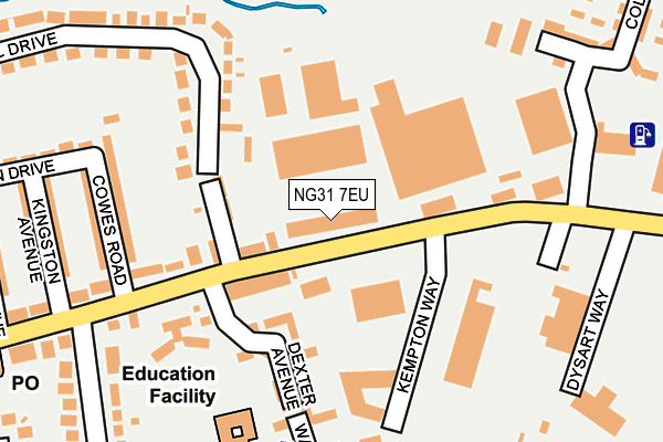
NG31 7EU is located in the Grantham Barrowby Gate electoral ward, within the local authority district of South Kesteven and the English Parliamentary constituency of Grantham and Stamford. The Sub Integrated Care Board (ICB) Location is NHS Lincolnshire ICB - 71E and the police force is Lincolnshire. This postcode has been in use since March 2012.


GetTheData
Source: OS OpenMap – Local (Ordnance Survey)
Source: OS VectorMap District (Ordnance Survey)
Licence: Open Government Licence (requires attribution)
| Easting | 490575 |
| Northing | 335679 |
| Latitude | 52.910915 |
| Longitude | -0.654580 |
GetTheData
Source: Open Postcode Geo
Licence: Open Government Licence
| Country | England |
| Postcode District | NG31 |
| ➜ NG31 open data dashboard ➜ See where NG31 is on a map ➜ Where is Grantham? | |
GetTheData
Source: Land Registry Price Paid Data
Licence: Open Government Licence
Elevation or altitude of NG31 7EU as distance above sea level:
| Metres | Feet | |
|---|---|---|
| Elevation | 70m | 230ft |
Elevation is measured from the approximate centre of the postcode, to the nearest point on an OS contour line from OS Terrain 50, which has contour spacing of ten vertical metres.
➜ How high above sea level am I? Find the elevation of your current position using your device's GPS.
GetTheData
Source: Open Postcode Elevation
Licence: Open Government Licence
| Ward | Grantham Barrowby Gate |
| Constituency | Grantham And Stamford |
GetTheData
Source: ONS Postcode Database
Licence: Open Government Licence
| January 2024 | Violence and sexual offences | On or near Warmington Avenue | 285m |
| January 2024 | Public order | On or near Warmington Avenue | 285m |
| December 2023 | Possession of weapons | On or near Warmington Avenue | 285m |
| ➜ Get more crime data in our Crime section | |||
GetTheData
Source: data.police.uk
Licence: Open Government Licence
| Kempton Way (Dysart Road) | Grantham | 40m |
| 7 Goodliff Road (Goodliff Road) | Grantham | 249m |
| Brading Avenue (Dysart Road) | Grantham | 326m |
| Brading Avenue (Dysart Road) | Grantham | 328m |
| Chelmsford Drive (Winchester Road) | Grantham | 329m |
| Grantham Station | 1km |
GetTheData
Source: NaPTAN
Licence: Open Government Licence
GetTheData
Source: ONS Postcode Database
Licence: Open Government Licence


➜ Get more ratings from the Food Standards Agency
GetTheData
Source: Food Standards Agency
Licence: FSA terms & conditions
| Last Collection | |||
|---|---|---|---|
| Location | Mon-Fri | Sat | Distance |
| Dysart Road Post Office | 17:00 | 12:00 | 326m |
| Asda | 16:30 | 11:30 | 660m |
| Westgate | 17:15 | 12:00 | 749m |
GetTheData
Source: Dracos
Licence: Creative Commons Attribution-ShareAlike
| Facility | Distance |
|---|---|
| Oceans Health & Fitness Dysart Road, Grantham Health and Fitness Gym, Swimming Pool, Studio | 81m |
| The Isaac Newton Primary School Dysart Road, Grantham Grass Pitches | 222m |
| Bluecoat Meres Academy The Avenue, Grantham Grass Pitches, Sports Hall | 631m |
GetTheData
Source: Active Places
Licence: Open Government Licence
| School | Phase of Education | Distance |
|---|---|---|
| The Isaac Newton Primary School Dysart Road, Grantham, NG31 7DG | Primary | 218m |
| West Grantham Church of England Secondary Academy The Avenue, Grantham, NG31 7PX | Secondary | 631m |
| Huntingtower Community Primary Academy Huntingtower Road, Grantham, NG31 7AU | Primary | 730m |
GetTheData
Source: Edubase
Licence: Open Government Licence
The below table lists the International Territorial Level (ITL) codes (formerly Nomenclature of Territorial Units for Statistics (NUTS) codes) and Local Administrative Units (LAU) codes for NG31 7EU:
| ITL 1 Code | Name |
|---|---|
| TLF | East Midlands (England) |
| ITL 2 Code | Name |
| TLF3 | Lincolnshire |
| ITL 3 Code | Name |
| TLF30 | Lincolnshire CC |
| LAU 1 Code | Name |
| E07000141 | South Kesteven |
GetTheData
Source: ONS Postcode Directory
Licence: Open Government Licence
The below table lists the Census Output Area (OA), Lower Layer Super Output Area (LSOA), and Middle Layer Super Output Area (MSOA) for NG31 7EU:
| Code | Name | |
|---|---|---|
| OA | E00133637 | |
| LSOA | E01026311 | South Kesteven 005D |
| MSOA | E02005480 | South Kesteven 005 |
GetTheData
Source: ONS Postcode Directory
Licence: Open Government Licence
| NG31 7DD | Dysart Road | 79m |
| NG31 7DQ | Dysart Road | 83m |
| NG31 7DH | Westbourne Place | 102m |
| NG31 7EL | Dexter Avenue | 153m |
| NG31 7EG | Wroxall Drive | 156m |
| NG31 7DJ | Dysart Road | 160m |
| NG31 7EH | Wroxall Drive | 176m |
| NG31 7DP | Cowes Road | 193m |
| NG31 7DL | Dysart Road | 199m |
| NG31 7GE | Becketts Close | 243m |
GetTheData
Source: Open Postcode Geo; Land Registry Price Paid Data
Licence: Open Government Licence