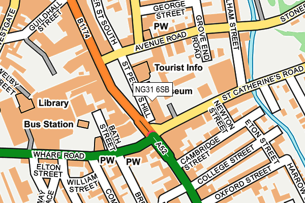
NG31 6SB is located in the Grantham St Wulfram's electoral ward, within the local authority district of South Kesteven and the English Parliamentary constituency of Grantham and Stamford. The Sub Integrated Care Board (ICB) Location is NHS Lincolnshire ICB - 71E and the police force is Lincolnshire. This postcode has been in use since January 1980.


GetTheData
Source: OS OpenMap – Local (Ordnance Survey)
Source: OS VectorMap District (Ordnance Survey)
Licence: Open Government Licence (requires attribution)
| Easting | 491568 |
| Northing | 335613 |
| Latitude | 52.910154 |
| Longitude | -0.639837 |
GetTheData
Source: Open Postcode Geo
Licence: Open Government Licence
| Country | England |
| Postcode District | NG31 |
| ➜ NG31 open data dashboard ➜ See where NG31 is on a map ➜ Where is Grantham? | |
GetTheData
Source: Land Registry Price Paid Data
Licence: Open Government Licence
Elevation or altitude of NG31 6SB as distance above sea level:
| Metres | Feet | |
|---|---|---|
| Elevation | 60m | 197ft |
Elevation is measured from the approximate centre of the postcode, to the nearest point on an OS contour line from OS Terrain 50, which has contour spacing of ten vertical metres.
➜ How high above sea level am I? Find the elevation of your current position using your device's GPS.
GetTheData
Source: Open Postcode Elevation
Licence: Open Government Licence
| Ward | Grantham St Wulfram's |
| Constituency | Grantham And Stamford |
GetTheData
Source: ONS Postcode Database
Licence: Open Government Licence
| January 2024 | Violence and sexual offences | On or near Railway Terrace | 282m |
| September 2023 | Vehicle crime | On or near Railway Terrace | 282m |
| June 2023 | Anti-social behaviour | On or near Railway Terrace | 282m |
| ➜ Get more crime data in our Crime section | |||
GetTheData
Source: data.police.uk
Licence: Open Government Licence
| Surgery (St Peter's Hill) | Grantham | 66m |
| Castlegate (Avenue Road) | Grantham | 119m |
| Bus Station (Wharf Road) | Grantham | 153m |
| Reel Cinema (St Catherine's Road) | Grantham | 163m |
| Bus Station (Wharf Road) | Grantham | 166m |
| Grantham Station | 0.4km |
GetTheData
Source: NaPTAN
Licence: Open Government Licence
GetTheData
Source: ONS Postcode Database
Licence: Open Government Licence

➜ Get more ratings from the Food Standards Agency
GetTheData
Source: Food Standards Agency
Licence: FSA terms & conditions
| Last Collection | |||
|---|---|---|---|
| Location | Mon-Fri | Sat | Distance |
| Grantham Delivery Office | 19:30 | 12:30 | 59m |
| Morrisons | 17:15 | 11:30 | 224m |
| St Catherines Road | 18:15 | 11:30 | 272m |
GetTheData
Source: Dracos
Licence: Creative Commons Attribution-ShareAlike
| Facility | Distance |
|---|---|
| Oceans (Closed) St. Catherines Road, Grantham Studio, Health and Fitness Gym | 85m |
| Puregym (Grantham Discovery Retail Park) London Road, Grantham Health and Fitness Gym | 305m |
| Feelgood Fitness (Grantham) The George Shopping Centre, Grantham Health and Fitness Gym, Studio | 334m |
GetTheData
Source: Active Places
Licence: Open Government Licence
| School | Phase of Education | Distance |
|---|---|---|
| Dudley House School 1 Dudley Road, Grantham, NG31 9AA | Not applicable | 337m |
| Grantham College Stonebridge Road, Grantham, NG31 9AP | 16 plus | 416m |
| St Wulfram's National Church of England Primary School Castlegate, Grantham, NG31 6SR | Primary | 482m |
GetTheData
Source: Edubase
Licence: Open Government Licence
The below table lists the International Territorial Level (ITL) codes (formerly Nomenclature of Territorial Units for Statistics (NUTS) codes) and Local Administrative Units (LAU) codes for NG31 6SB:
| ITL 1 Code | Name |
|---|---|
| TLF | East Midlands (England) |
| ITL 2 Code | Name |
| TLF3 | Lincolnshire |
| ITL 3 Code | Name |
| TLF30 | Lincolnshire CC |
| LAU 1 Code | Name |
| E07000141 | South Kesteven |
GetTheData
Source: ONS Postcode Directory
Licence: Open Government Licence
The below table lists the Census Output Area (OA), Lower Layer Super Output Area (LSOA), and Middle Layer Super Output Area (MSOA) for NG31 6SB:
| Code | Name | |
|---|---|---|
| OA | E00133696 | |
| LSOA | E01026323 | South Kesteven 004D |
| MSOA | E02005479 | South Kesteven 004 |
GetTheData
Source: ONS Postcode Directory
Licence: Open Government Licence
| NG31 6QF | St Peters Hill | 88m |
| NG31 6TS | St Catherines Road | 92m |
| NG31 6BA | Wharf Road | 121m |
| NG31 6TL | Grove End Road | 127m |
| NG31 6QB | St Peters Hill | 139m |
| NG31 6EJ | London Road | 147m |
| NG31 6HA | Newton Street | 148m |
| NG31 6TT | St Catherines Road | 153m |
| NG31 6EX | London Road | 156m |
| NG31 6EZ | Cambridge Street | 157m |
GetTheData
Source: Open Postcode Geo; Land Registry Price Paid Data
Licence: Open Government Licence