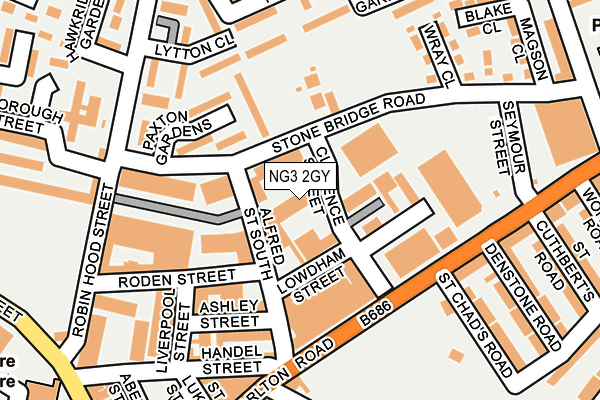
NG3 2GY is located in the St. Ann's electoral ward, within the unitary authority of Nottingham and the English Parliamentary constituency of Nottingham East. The Sub Integrated Care Board (ICB) Location is NHS Nottingham and Nottinghamshire ICB - 52R and the police force is Nottinghamshire. This postcode has been in use since January 1980.


GetTheData
Source: OS OpenMap – Local (Ordnance Survey)
Source: OS VectorMap District (Ordnance Survey)
Licence: Open Government Licence (requires attribution)
| Easting | 458253 |
| Northing | 340292 |
| Latitude | 52.956867 |
| Longitude | -1.134307 |
GetTheData
Source: Open Postcode Geo
Licence: Open Government Licence
| Country | England |
| Postcode District | NG3 |
| ➜ NG3 open data dashboard ➜ See where NG3 is on a map ➜ Where is Nottingham? | |
GetTheData
Source: Land Registry Price Paid Data
Licence: Open Government Licence
Elevation or altitude of NG3 2GY as distance above sea level:
| Metres | Feet | |
|---|---|---|
| Elevation | 40m | 131ft |
Elevation is measured from the approximate centre of the postcode, to the nearest point on an OS contour line from OS Terrain 50, which has contour spacing of ten vertical metres.
➜ How high above sea level am I? Find the elevation of your current position using your device's GPS.
GetTheData
Source: Open Postcode Elevation
Licence: Open Government Licence
| Ward | St. Ann's |
| Constituency | Nottingham East |
GetTheData
Source: ONS Postcode Database
Licence: Open Government Licence
| January 2024 | Violence and sexual offences | On or near Paxton Gardens | 135m |
| January 2024 | Violence and sexual offences | On or near Paxton Gardens | 135m |
| November 2023 | Criminal damage and arson | On or near Paxton Gardens | 135m |
| ➜ Get more crime data in our Crime section | |||
GetTheData
Source: data.police.uk
Licence: Open Government Licence
| St Chads Road (Carlton Road) | Sneinton | 144m |
| Handel Street (Carlton Road) | Sneinton | 144m |
| Handel Street (Carlton Road) | Sneinton | 186m |
| Roden Street (Robin Hood Street) | St Anns | 206m |
| Hawkridge Gardens (Beacon Hill Rise) | St Anns | 207m |
| Lace Market Tram Stop (Fletcher Gate) | Nottingham | 853m |
| Old Market Square Tram Stop (South Parade) | Nottingham | 1,182m |
| Royal Centre Tram Stop (Wollaton Street) | Nottingham | 1,210m |
| Nottingham Station Tram Stop (N/A) | Nottingham | 1,348m |
| Ntu Tram Stop (Goldsmith Street) | Nottingham Trent University In City Centre | 1,442m |
| Nottingham Station | 1.4km |
| Netherfield Station | 3.7km |
| Carlton Station | 3.8km |
GetTheData
Source: NaPTAN
Licence: Open Government Licence
GetTheData
Source: ONS Postcode Database
Licence: Open Government Licence


➜ Get more ratings from the Food Standards Agency
GetTheData
Source: Food Standards Agency
Licence: FSA terms & conditions
| Last Collection | |||
|---|---|---|---|
| Location | Mon-Fri | Sat | Distance |
| Denstone Road | 17:30 | 12:30 | 182m |
| Sneinton Elements P O | 17:30 | 11:30 | 344m |
| Beaconhill Rise | 17:30 | 11:00 | 360m |
GetTheData
Source: Dracos
Licence: Creative Commons Attribution-ShareAlike
| Facility | Distance |
|---|---|
| Winners Gym Roden Street, Nottingham Health and Fitness Gym | 129m |
| Bushido Mma Academy (Closed) Ashley Street, Nottingham Health and Fitness Gym, Studio | 169m |
| King Edwards Park Carlton Road, Nottingham Grass Pitches | 217m |
GetTheData
Source: Active Places
Licence: Open Government Licence
| School | Phase of Education | Distance |
|---|---|---|
| Sutherland House School Bath Street, Nottingham, NG1 1DA | Not applicable | 416m |
| Sneinton St Stephen's CofE Primary School Windmill Lane, Sneinton, Nottingham, NG2 4QB | Primary | 444m |
| Rosehill School St Matthias Road, Nottingham, NG3 2FE | Not applicable | 453m |
GetTheData
Source: Edubase
Licence: Open Government Licence
The below table lists the International Territorial Level (ITL) codes (formerly Nomenclature of Territorial Units for Statistics (NUTS) codes) and Local Administrative Units (LAU) codes for NG3 2GY:
| ITL 1 Code | Name |
|---|---|
| TLF | East Midlands (England) |
| ITL 2 Code | Name |
| TLF1 | Derbyshire and Nottinghamshire |
| ITL 3 Code | Name |
| TLF14 | Nottingham |
| LAU 1 Code | Name |
| E06000018 | Nottingham |
GetTheData
Source: ONS Postcode Directory
Licence: Open Government Licence
The below table lists the Census Output Area (OA), Lower Layer Super Output Area (LSOA), and Middle Layer Super Output Area (MSOA) for NG3 2GY:
| Code | Name | |
|---|---|---|
| OA | E00173484 | |
| LSOA | E01033401 | Nottingham 023F |
| MSOA | E02002890 | Nottingham 023 |
GetTheData
Source: ONS Postcode Directory
Licence: Open Government Licence
| NG3 2DP | Lowdham Street | 90m |
| NG3 2ET | Clarence Street | 94m |
| NG3 2FB | Carlton Road | 111m |
| NG3 2AD | Alfred Street South | 126m |
| NG3 2DN | Carlton Road | 135m |
| NG3 2GG | Paxton Gardens | 139m |
| NG3 2GN | Ferrers Walk | 166m |
| NG3 1JE | Handel Street | 184m |
| NG3 2AS | Carlton Road | 186m |
| NG3 2AP | Carlton Road | 194m |
GetTheData
Source: Open Postcode Geo; Land Registry Price Paid Data
Licence: Open Government Licence
| Bath Street | At Any Time | 311m |
| Bath Street | At Any Time | 316m |
| Brook Street | At Any Time | 403m |
GetTheData
Source: Disabled parking spaces, Nottingham City Council, 19/02/2013
Licence: Open Government Licence